Economy
Typhoon No. 10 - Typhoon Bualoi
On the night of September 26th, the storm entered the South China Sea, becoming the 10th typhoon of 2025.
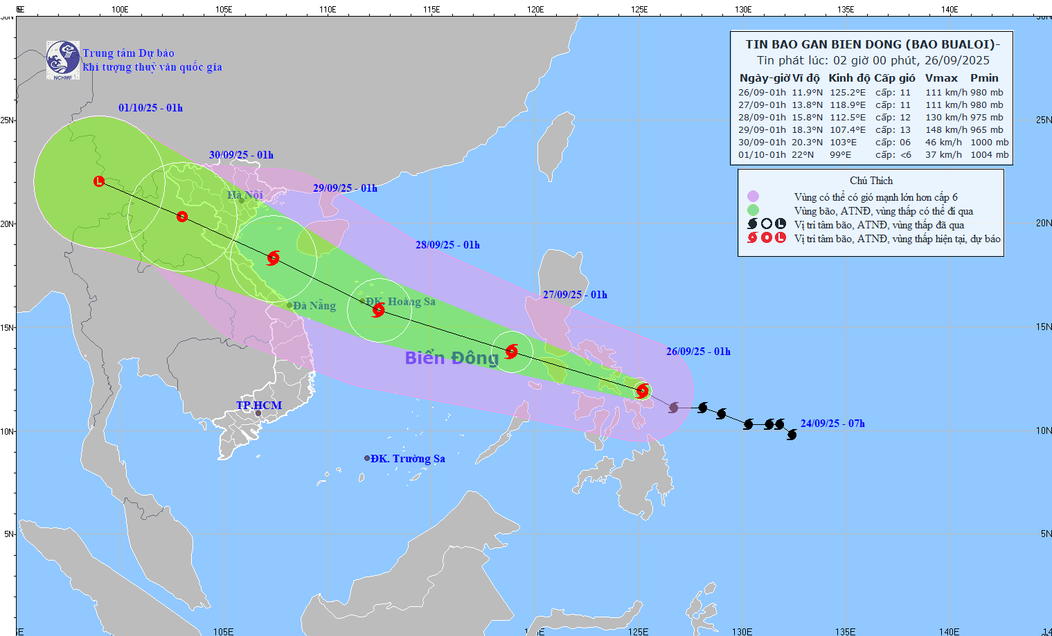
At 1:00 AM on September 26th, the storm's center was located at approximately 11.9°N; 125.2°E, over the central Philippines.
- Maximum wind speed: level 11 (103–117 km/h), gusts up to level 14.
- Travel west-northwest at a speed of 25–30 km/h.
- Forecast: On the night of September 26th, the storm will enter the East Sea, becoming the 10th storm of 2025.
📍Forecast of developments (next 24–72 hours)
- 1:00 AM on September 27thHeading west-northwest at 25-30 km/h, entering the South China Sea. Location: 13.8°N–118.9°E, wind speed level 11, gusts level 14.
▪ Hazard zone: 11.5–16.5°N; East of the 116.5°E meridian.
▪ Level of natural disaster risk: level 3 (Northeast and Central East Sea). - 1:00 AM on September 28thMoving west-northwest at 25-30 km/h, with the possibility of strengthening. Located at 15.8°N–112.5°E, wind speed level 12, gusts up to level 15.
▪ Hazard zone: 12.0–19.0°N; East longitude 110.0°E.
▪ Level of natural disaster risk: Level 3 (Northern & Central South China Sea, including the Paracel Islands). - 1:00 AM on September 29thMoving west-northwest at approximately 25 km/h, continuing to strengthen. Location: 18.3°N–107.4°E, wind speed level 12–13, gusts up to level 16.
▪ Hazard zone: 12.5–21.0°N; West longitude 115.0°E.
▪ Level of natural disaster risk: level 3 (Northwest & Central East Sea, Hoang Sa, Southern Gulf of Tonkin, sea area from Quang Tri to Quang Ngai).
📍Warning (next 72–120 hours)
The storm is moving rapidly in a west-northwest direction at 20–25 km/h, gradually weakening in intensity.
📍Predicted impact
🌊Strong winds, big waves
- From the evening of September 26th: the northeastern and central parts of the East Sea will experience winds of force 6-7, later increasing to force 8-9.
- Near the storm's center: winds of force 10–12, gusts of force 15, waves 5–7 m high; extremely rough seas.
- Ships in the danger zone are at risk of encountering thunderstorms, tornadoes, strong winds, and high waves.

