
TYPHOON WARNING FOR THE SOUTH CHINA SEA (Typhoon No. 02)
At 04:00 on July 25th, the typhoon's center was located at approximately 20.3° North latitude and 118.8° East longitude, in the northeastern part of the South China Sea, about 580km southeast of Hong Kong (China). The strongest winds near the center of the typhoon reached levels 10-11 (89-117 km/h), with gusts up to level 13. The typhoon was moving west-northwest at a speed of approximately 20 km/h.
📌Storm development over the next 24-60 hours:
The storm is moving in a west-northwest direction at a speed of 20-25 km/h, and at 04:00 on July 26th it was located at approximately 22.8° North latitude; 115.1° East longitude, in the coastal waters of Guangdong province (China).
The storm is likely to intensify, reaching level 12, with gusts up to level 14. The danger zone is located north of latitude 18.5°N and east of longitude 114.0°E. The level of natural disaster risk is level 3 for the northeastern sea area of the North East Sea.
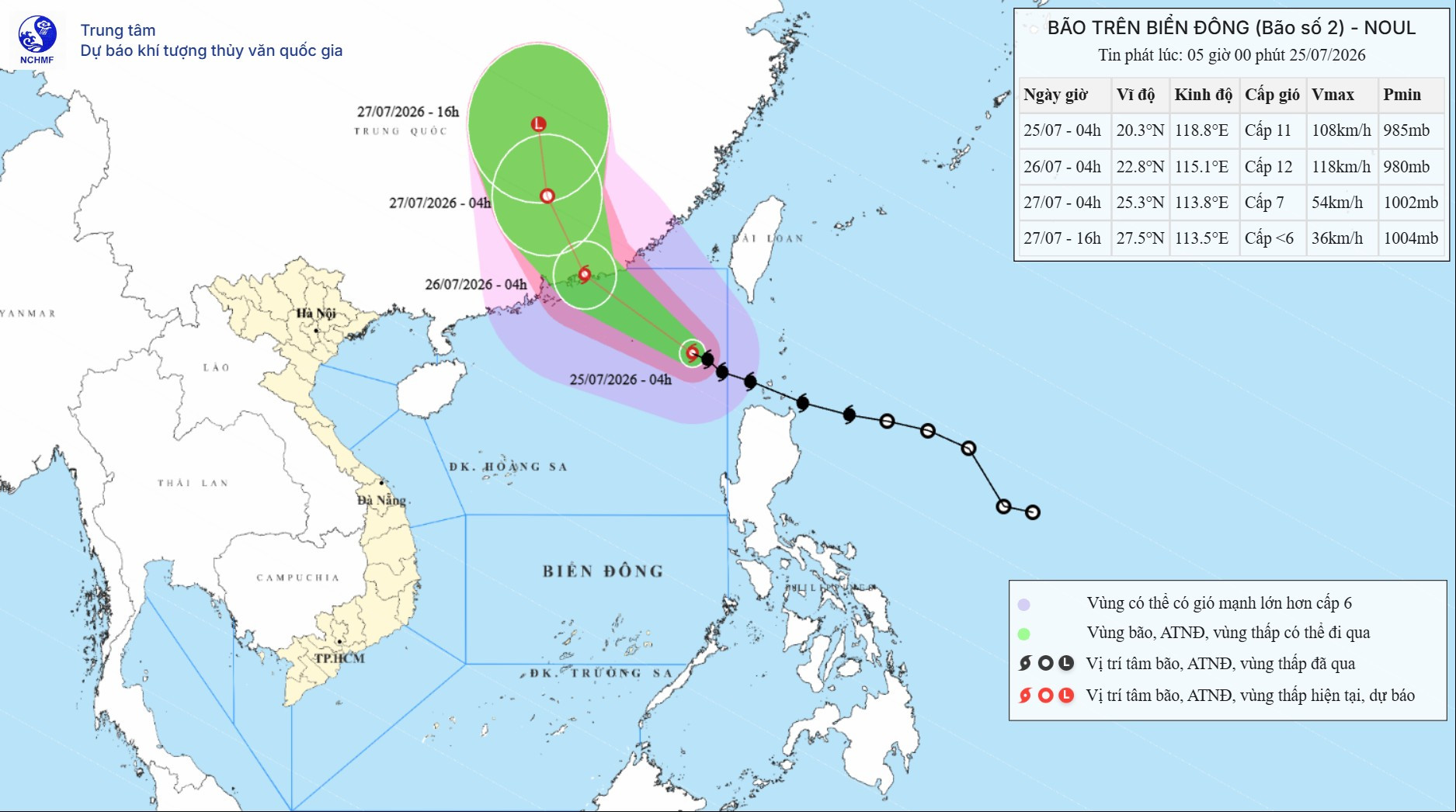
The storm continues to move in a north-northwest direction at a speed of 15-20 km/h, making landfall in Guangdong province (China).
As of 04:00 on July 27th, the storm was located at approximately 25.3° North latitude; 113.8° East longitude.
The storm gradually weakened into a tropical depression, with intensity level 6-7, gusting to level 9. The danger zone is located north of latitude 20.5°N and east of longitude 113.0°E.
Level of natural disaster risk: Level 3 for the northern sea area of the North East Sea region.
The storm then moved in a North-Northwest direction at a speed of 15-20 km/h. By 4 PM on July 27th, the storm was located at approximately 27.5° North latitude; 113.5° East longitude, over land in Hunan Province (China). The storm weakened into a low-pressure area, with an intensity below level 6.
⚠️Forecast of storm impacts
According to current forecasts, Typhoon NOUL is mainly moving in a west-northwest direction, with over an 80% probability of making landfall in Guangdong province (China) and is unlikely to directly affect mainland Vietnam.
🌊Strong winds and high waves at sea.
In the northeastern part of the South China Sea, winds are strong at force 6-7, with waves 4.0-6.0m high. Near the storm's center, winds are strong at force 10-11, later increasing to force 11-12, gusting to force 14, with waves 5.0-7.0m high. The sea is extremely rough.
⛴️ Vessels operating in the aforementioned hazardous area are susceptible to the effects of thunderstorms, tornadoes, strong winds, and large waves.


