
TYPHOON WARNING FOR THE SOUTH CHINA SEA (Typhoon No. 05)
At 4 PM on September 1st, the typhoon's center was located at approximately 20.2 degrees North latitude and 115.1 degrees East longitude, in the northern part of the South China Sea. The strongest winds near the center of the typhoon were at level 8 (62-74 km/h), with gusts up to level 10. It was moving northeast at a speed of about 20 km/h.
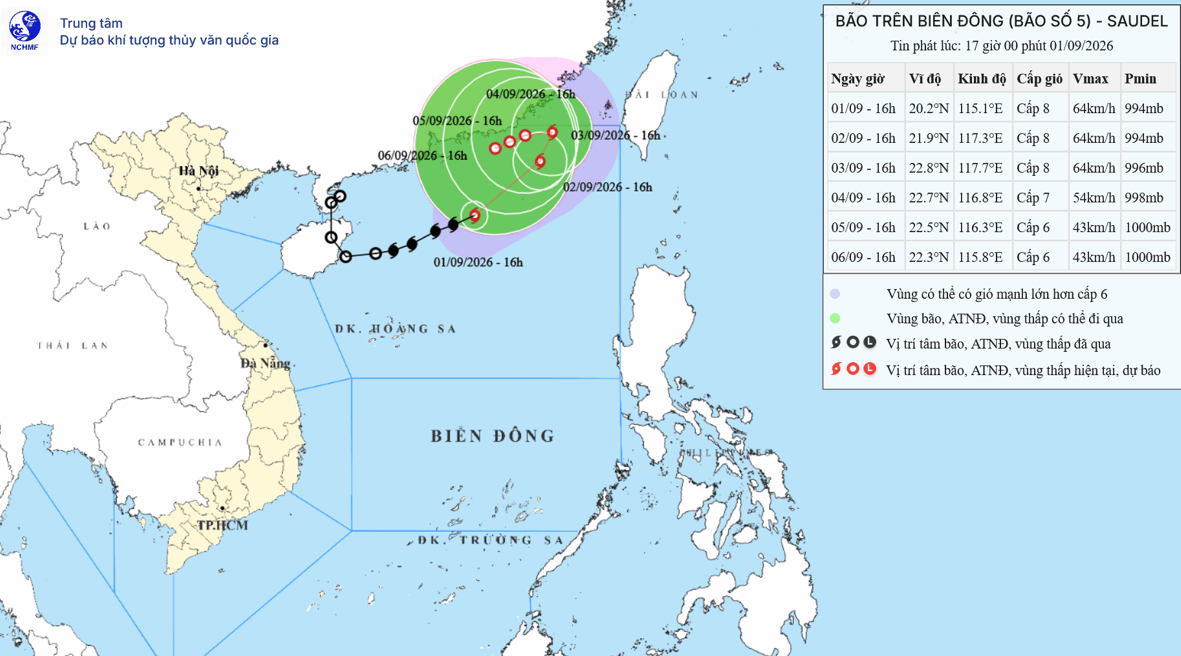
Forecast of storm/tropical depression developments (over the next 24 to 72 hours)
| Forecast time | Direction, speed | Location | Intensity | Hazardous area | Level of natural disaster risk (Affected area) |
| 13 hours September 2nd | Northeast, approximately 15 km/h | 21.8N-117.1E; in the northeastern sea area of the North East Sea region. | Level 8, then level 10 | North of latitude 18.5N; 112.5-118.5E | Level 3: Northern sea area of the North East Sea region |
| 13 hours September 3rd | Northeast, then Northwest 5-10 km/h | 22.8N-117.7E; in the northeastern sea area of the North East Sea region. | Level 8, then level 10 | North of latitude 20.5N; 116.0-119.5E | Level 3: Northeast sea area of the North East Sea region |
| 13 hours September 4th | West, 3-5 km/h | 22.8N-116.8E; in the sea area southeast of Guangdong province (China) | Gradually weakening into a tropical depression. Level 7, gusts up to level 9. | North of latitude 21.5N; 116.0-119.0E | Level 3: the northeastern sea area of the North East Sea region. |
📍Tropical depression warning (over the next 72 to 120 hours)
Over the next 72 to 120 hours, the tropical depression will move in a west-southwest direction, traveling approximately 3 km per hour, gradually weakening in intensity.
📍Forecast of the storm's impact:Strong winds, big waves
At sea:In the northern part of the North East Sea, winds will be strong at force 6-7, gusting to force 8-9, with waves 3.0-5.0m high; in the area near the storm's center, winds will be strong at force 8, gusting to force 10, with waves 4.0-6.0m high; the sea will be very rough.
Vessels operating in the aforementioned hazardous areas are susceptible to the effects of thunderstorms, tornadoes, strong winds, and high waves.


