TYPHOON WARNING FOR THE SOUTH CHINA SEA (Typhoon No. 15)
At 04:00 on November 26th, the typhoon's center was located at approximately 12.2 degrees North latitude and 119.1 degrees East longitude, about 540 km east of Song Tu Tay Island. The strongest winds near the center of the typhoon were at level 8 (62-74 km/h), with gusts up to level 10. It was moving northwest at a speed of 20-25 km/h.
1. Forecast of developments over the next 24 to 48 hours:
+) 4:00 AM on November 27th:The storm is moving in a west-northwest direction at a speed of 15-20 km/h.
Location:13.0N-115.2E; over the central South China Sea, approximately 200km north-northeast of Song Tu Tay Island; likely to intensify; Intensity: level 10, gusts up to level 13.
Affected area:The area in the central South China Sea (including the waters north of the Spratly Islands special administrative region).
+) 4:00 AM on November 28th:The storm is moving in a west-southwest direction at a speed of 5-10 km/h.
Location:12.4N-113.5E; over the central South China Sea, approximately 150km north-northwest of Song Tu Tay Island; likely to intensify; Intensity: Level 11, gusts up to level 14.
Affected area:the central area of the South China Sea (including the waters north of the Spratly Islands special administrative region).
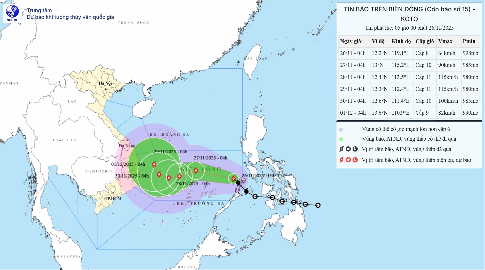
+) 4:00 AM on November 29th:The storm is moving westward at a speed of approximately 5 km/h.
Location: 12.3N-112.4E; over the sea area west of the central South China Sea, about 250km west-northwest of Song Tu Tay Island; Intensity: Level 11, gusts up to level 14.
Affected area:the central area of the South China Sea (including the waters north of the Spratly Islands special administrative region).
2. Warning about developments over the next 48 to 72 hours.i:
Over the next 72 to 120 hours, the storm moved northwest at a speed of approximately 5 km/h and gradually weakened in intensity.
At sea:In the central area of the South China Sea (including the sea area north of the Truong Sa Special Administrative Region), winds will be strong at force 6-7; in the area near the storm's center, winds will be strong at force 8-10, gusting to force 13; sea waves will be 4.0-6.0m high, and 6.0-8.0m near the storm's center; the sea will be very rough.
Warning:Around November 27-28, the central area of the South China Sea (including the waters north of the Truong Sa Special Administrative Region) is likely to be affected by strong winds of level 11, gusting to level 14, with waves reaching 7.0-9.0m in height, and extremely rough seas.
Vessels operating in the aforementioned hazardous areas are susceptible to the effects of thunderstorms, tornadoes, strong winds, and high waves.

