
Update on Typhoon Ragasa (Typhoon No. 9) at 10:00 AM today, September 23, 2025
At 10:00 AM on September 23rd, the center of Typhoon Ragasa was located at approximately 20.2 degrees North latitude and 117.7 degrees East longitude, with maximum wind speeds reaching levels 16-17.
Update on Typhoon Ragasa (Typhoon No. 9) at 10:00 AM today.
At 10:00 AM on September 23rd, the center of Typhoon Ragasa was located at approximately 20.2 degrees North latitude and 117.7 degrees East longitude, about 790km east of the Leizhou Peninsula (China). The strongest winds reached levels 16-17, or 184 to 221 km/h, with gusts exceeding level 17.
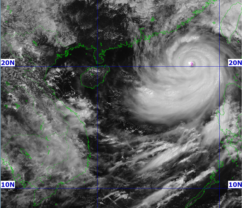
Over the next three hours, the storm will move west-northwest at a speed of approximately 20 km/h, maintaining its very strong intensity.
Over the next 24 hours, the northern South China Sea, especially near the center of Typhoon Ragasa, will experience gusts of wind at levels 15-17, waves higher than 10 meters, and extremely rough seas.
In the southern part of the South China Sea, including the Paracel Islands, strong southwest winds of force 7-9, gusting to force 10-11, will bring waves 4 to 6 meters high.
The Truong Sa sea area and the region from Dak Lak to Ho Chi Minh City were also affected by winds of force 6-7 and waves 2 to 5 meters high.
Warning issued for Typhoon Ragasa (Typhoon No. 9) from September 24th.
Forecasts indicate that on September 24th, both day and night, wind speeds in the northern part of the East Sea will remain at level 14-16, gusting above level 17, with waves reaching 7-9 meters in height, and exceeding 10 meters in some areas.
The Gulf of Tonkin is also beginning to be directly affected, with strong winds of force 7-9, and winds near the center of Typhoon Ragasa potentially reaching force 10-12, gusting to force 14, and waves 4-6 meters high.
The level of natural disaster risk is warned at level 4 in the northern South China Sea, level 3 in the Gulf of Tonkin, and level 2 in other sea areas.
The combined influence of Typhoon Ragasa and the monsoon has caused very heavy rainfall in many areas. From September 23rd, scattered thunderstorms began in Northern Vietnam, Thanh Hoa, Nghe An, and the central provinces, with rainfall generally ranging from 15-30mm, and exceeding 80mm in some places. The Central Highlands and Southern Vietnam also experienced heavy rain, with localized areas receiving over 100mm.
Particularly from the night of September 24th to September 26th, Northern Vietnam, Thanh Hoa, and Nghe An are forecast to experience extremely heavy rainfall with total amounts generally ranging from 100-250mm, and exceeding 400mm in some areas. Rainfall intensity exceeding 100mm/3h could cause flash floods and landslides in mountainous areas and widespread flooding in plains and urban areas.
Typhoon Ragasa, along with widespread heavy rain, is forecast to severely impact ships and maritime activities. On land, the risk of flash floods, landslides, and inundation is high. Residents in the Northern, North Central, and coastal areas of Central Vietnam should closely monitor weather forecasts and take timely countermeasures.


