Latest news on Typhoon No. 5
According to forecasts, from tonight (August 24th), strong winds will gradually increase to level 7-9 in Nghe An province, reaching level 10-12 near the storm's center, with gusts up to level 14-15.
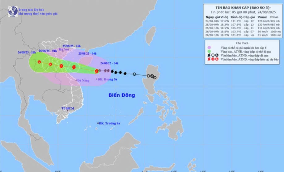
HOhi 04 giuhngaAugust 24thThe storm's center is located at approximately 17.6 degrees North latitude and 111.7 degrees East longitude, in the sea north of the Hoang Sa (Paracel) Islands, about 660km east-southeast of Nghe An province and about 640km east of Ha Tinh province. The strongest winds near the storm's center are at level 12 (118-133 km/h), with gusts up to level 15; it is moving westward at a speed of about 20 km/h.
Dselfnewspaperễn biunmarketablenbao(within 24 hours)emperorn 60 hoursuhtOhi):
| Silkuhi pointmdselfbao | Directionsng, tspeed | Vpoopintelligence | Laughngdegree | Hazardous areaem | Ctemperaturerincubatei ro natural disaster (Area vselfc chpoopuhernhopenng) |
| 04:00 on August 25th | West-northwest, approximately 20 km/h | 18.3N-107.8E; in the southern part of the Gulf of Tonkin; approximately 230km east of Nghe An and 210km east of Ha Tinh. | 12-13, gusts up to 15; and it could get even stronger. | Latitude 16.0N-20.0N; Longitude 106.5E-114.5E | Cap 3: The western sea area of the North East Sea (including the Hoang Sa Special Zone), the Gulf of Tonkin, and the southern sea area of Quang Tri-Hue City (including Hon Ngu Island and Con Co Special Zone) |
| 04:00 on August 26th | West-northwest, 15-20 km/h and gradually slowing down. | 18.8N-103.7E; over the Upper Laos region | 6-7, jump 9 | Latitude 16.0N-20.0N; west of longitude 108.5E | Cap 3: Gulf of Tonkin, southern Quang Tri-Hue sea area (including Hon Ngu Island, Con Co Special Economic Zone) Cap 4: The coastal waters from Thanh Hoa to Quang Tri, and the inland areas of the provinces from Thanh Hoa to northern Quang Tri. |
| 4 PM on August 26th | West-northwest, 15-20 km/h, gradually weakening into a low-pressure area. | 19.2N-101.8E; overland in the Upper Laos region | < level 6 | Latitude 16.5N-20.0N; west of longitude 105.5E |
Dimpact forecastng cincubateabao:From noon and afternoon of August 24th, the sea area of Nghe An province (including Hon Ngu island) will experience increasingly strong winds, reaching levels 6-8, then increasing to levels 9-10, with winds near the storm's center reaching levels 11-13, gusting to level 15; sea waves will be 4.0-6.0m high, and 7.0-9.0m near the center. The sea will be extremely rough.
Coastal areas of Nghe An province experienced storm surges of 0.5-1.5m. Water levels at Hon Ngu (Nghe An) reached 3.5-4.0m.
CherNewspaper:Weather conditions at sea and in coastal areas during storms are extremely dangerous and unsafe for any vehicles or structures operating in hazardous zones, such as: tourist boats, passenger ships, cargo ships, cages, rafts, aquaculture farms, dikes, embankments, and coastal roads. These vessels are highly likely to capsize, be destroyed, or be submerged due to strong winds, large waves, and rising sea levels.
On the groundt lièn:From the night of August 24th, strong winds gradually increased to level 7-9 in Nghe An province, reaching level 10-12 near the storm's center, with gusts up to level 14-15.
From the night of August 24th to the end of August 26th, the Nghe An province area is likely to experience a period of heavy to very heavy rain with rainfall amounts generally ranging from 150-350mm, and in some localized areas exceeding 500mm. A warning is issued regarding the risk of heavy rainfall (>200mm/3h).

