
BREAKING NEWS ON TYPHOON NO. 4 (at 12:00 PM on August 23, 2026)
Location of the storm's center: Approximately 20.6 degrees North latitude; 108.0 degrees East longitude, over the sea area between Quang Ninh and Hai Phong, 145 km east of Quang Ninh, 150 km east of Hai Phong city, and about 60 km north of Bach Long Vi special economic zone. Maximum wind speed: Level 8-9 (62-88 km/h), gusts up to level 11. Forecast: The storm will move very little in the next 3 hours.
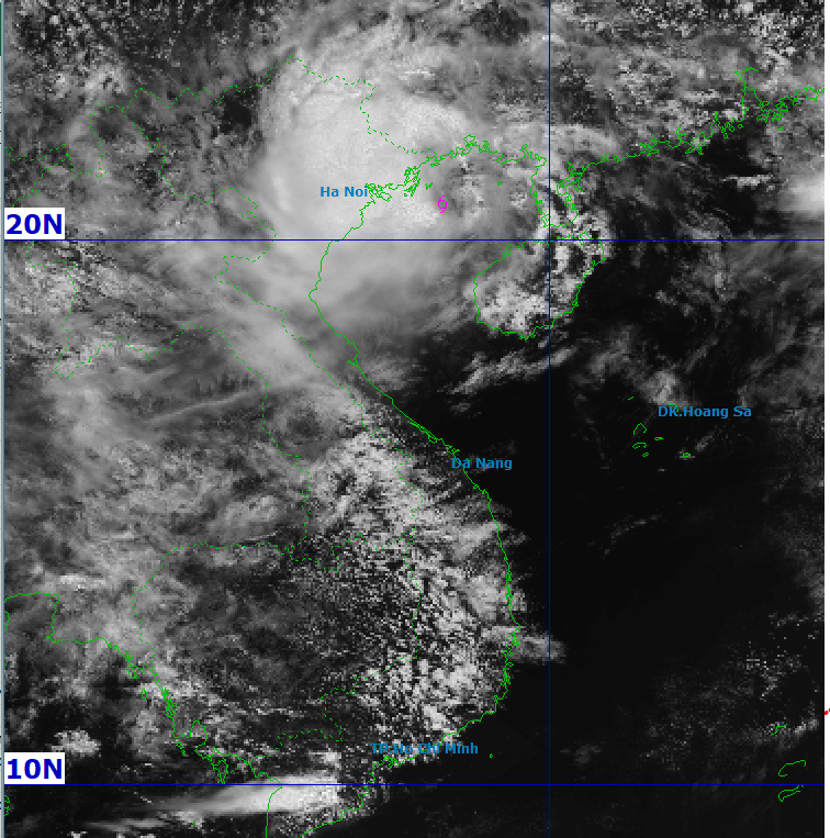
Storm warning (for the next 72 to 96 hours):
Over the next 72 to 96 hours, the tropical depression is likely to move northward and then north-northwestward at a speed of approximately 5 km per hour, gradually weakening into a localized area.
Forecast of the storm's impact:
- At sea:Affected areas: Gulf of Tonkin (including the special economic zones of Bach Long Vi, Van Don, Co To, Cat Hai; Hon Dau Island), coastal waters of Quang Ninh province and Hai Phong city.
Risk: Strong winds of force 6-7, reaching force 8-9 in areas near the storm's center, with gusts up to force 10-11; sea waves 2.0-4.0m high; very rough seas.
Main impacts: Hazardous weather conditions can cause capsizing, sinking, or damage to fishing vessels, cargo ships, tourist boats, and other vessels operating at sea; aquaculture cages, mooring areas, and coastal structures are at risk of damage. Fisheries, transportation, and tourism activities at sea are likely to be disrupted.
- Coastal mainland areas:Affected areas: Coastal mainland of Quang Ninh province and Hai Phong city.
Risk: Strong winds of force 6, sometimes force 7, gusts of force 8-9.
Main impacts: Strong winds can rip off roofs, damage temporary structures, knock down trees and billboards; affect power systems and transportation.
- Impacts from heavy rainfall:Affected areas: Northeast Vietnam, southern Phu Tho province and Thanh Hoa province.
Risk: From August 23rd to August 24th, rainfall is expected to be 50-100mm, with some areas exceeding 200mm; specifically in Quang Ninh, Hai Phong City, Lang Son, Bac Ninh, Hung Yen, and Ninh Binh, rainfall is expected to be 90-180mm, with some areas exceeding 300mm. Heavy rain is expected to gradually decrease from the night of August 24th.
Main impacts: Heavy rainfall may cause flooding in urban areas, industrial zones, and low-lying areas; increasing the risk of flooding on small rivers and streams, flash floods, and landslides in mountainous areas.
Thunderstorms, tornadoes:Due to the influence of the storm's circulation, there is a risk of thunderstorms, tornadoes, and strong gusts of wind.


