From tonight (August 24th) until the end of August 26th, Nghe An province is forecast to experience heavy to very heavy rain, with rainfall amounts generally ranging from 200-400mm, and in some localized areas exceeding 600mm.
On land: From the night of August 24th, strong winds will gradually increase to level 8-10 in Nghe An province, reaching level 11-13 near the storm's center, with gusts up to level 14-15.
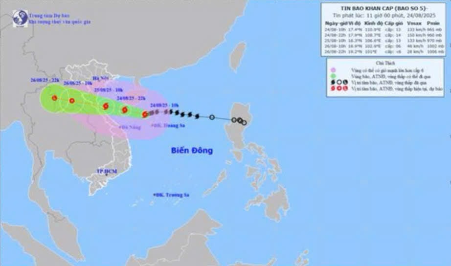
HOhi 10 giuhngaAugust 24thThe storm's center is located at approximately 17.4 degrees North latitude and 110.9 degrees East longitude, in the sea northwest of the Hoang Sa (Paracel) Islands, about 580km from Nghe An and about 560km east-southeast of Ha Tinh. The strongest winds near the storm's center are at level 12-13 (118-149 km/h), with gusts up to level 15; it is moving westward at a speed of about 20 km/h.
Dselfnewspaperễn biunmarketablenbao(within 24 hours)emperorn 60 hoursuhtOhi):
| Silkuhi pointmdselfbao | Directionsng, tspeed | Vpoopintelligence | Laughngdegree | Hazardous areaem | Ctemperaturerincubatei ro natural disaster (Area vselfc chpoopuhernhopenng) |
| 22:00 on August 24th | West-northwest, approximately 20 km/h | 17.9N-108.7E; in the southern part of the Gulf of Tonkin; approximately 300km east-southeast of Nghe An and 270km east-southeast of Ha Tinh. | 13-14, gusts up to 16 | Latitude 16.0N-20.0N; west of longitude 112.5E | Cap 3: The western sea area of the North East Sea (including the Hoang Sa Special Zone), the Gulf of Tonkin, and the southern sea area of Quang Tri-Hue City (including Hon Ngu Island and Con Co Special Zone). |
| 10:00 AM on August 25th | West-northwest, approximately 20 km/h | 18.3N-106.6E; in the sea area from Thanh Hoa to Quang Tri | 12-13, gusts up to 15 | Latitude 16.0N-20.0N; west of longitude 112.5E | Cap 3: The western sea area of the North East Sea, the Gulf of Tonkin, and the southern sea area of Quang Tri-Hue City (including Hon Ngu Island and Con Co Special Economic Zone) Cap 4: The coastal waters from Thanh Hoa to Quang Tri |
| 10:00 AM on August 26th | West-northwest, 15-20 km/h and gradually weakening. | 18.9N-102.9E; in the Laos-Thailand border area | 6, snatch 8 | Latitude 16.0N-20.0N; west of longitude 108.5E | Cap 3: Gulf of Tonkin, southern Quang Tri-Hue sea area (including Hon Ngu Island, Con Co Special Economic Zone) Cap 4: The coastal waters from Thanh Hoa to Quang Tri, and the inland areas of the provinces from Thanh Hoa to northern Quang Tri. |
| 22:00 on August 26th | West-northwest, 15-20 km/h, gradually weakening into a low-pressure area. | 19.2N-101.0E; overland in the Upper Laos region | < level 6 | Latitude 16.5N-20.0N; west of longitude 105.5E |
Dimpact forecastng cincubateabao:From noon and afternoon of August 24th, the sea area of Nghe An province (including Hon Ngu island) will experience increasingly strong winds, reaching levels 7-9, then increasing to levels 10-11, with winds near the storm's center reaching levels 12-14, gusting to level 16; sea waves will be 5.0-7.0m high, and 8.0-10.0m near the storm's center. The sea will be extremely rough.
Coastal areas of Nghe An province are experiencing storm surges of 0.5-1.5m. Water levels at Hon Ngu (Nghe An) are 3.2-3.6m high. There is a high risk of flooding in low-lying coastal areas and river mouths due to storm surges and large waves in the afternoon and evening of August 25th.
CherNewspaper:Weather conditions at sea and in coastal areas during storms are extremely dangerous and unsafe for any vehicles or structures operating in hazardous zones, such as: tourist boats, passenger ships, cargo ships, cages, rafts, aquaculture farms, dikes, embankments, and coastal roads. These vessels are highly likely to capsize, be destroyed, or be submerged due to strong winds, large waves, and rising sea levels.
On the groundt lièn:From the night of August 24th, strong winds gradually increased to level 8-10 in the mainland of Nghe An province, reaching level 11-13 near the storm's center, with gusts up to level 14-15.
From the night of August 24th to the end of August 26th, the Nghe An province area is likely to experience a period of heavy to very heavy rain with rainfall amounts generally ranging from 200-400mm, and locally exceeding 600mm. A warning is issued regarding the risk of heavy rainfall (>150-200mm/3h).

