
Tropical depression has formed over the South China Sea.
(Baonghean.vn) - According to the Central Meteorological and Hydrological Forecasting Center, a tropical depression is currently active in the sea southeast of the Philippines (as of today, December 27).
At 7 o'clockThe center of the tropical depression is located at approximately 10.7 degrees North latitude and 129.5 degrees East longitude, about 450km east-southeast of the central Philippine coast. The strongest winds near the center of the tropical depression are at level 7 (50-60 km/h).level 9 gust.
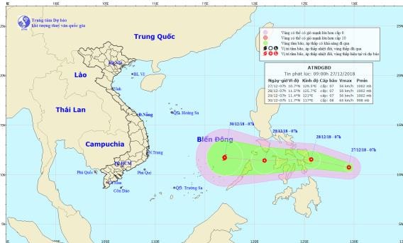 |
| The path and location of the tropical depression. Photo: Central Meteorological and Hydrological Center. |
Forecast for the next 24 hours,The tropical depression is moving in a west-northwest direction at a speed of approximately 15-20 km/h. By 07:00 on December 28th, the center of the tropical depression was located at approximately 11.5 degrees North latitude; 125.7 degrees East longitude, right off the coast of central the Philippines. The strongest winds near the center of the tropical depression were at level 7 (50-60 km/h).level 9 gust.
Over the next 24 to 48 hours,The tropical depression is moving westward at a speed of approximately 25 km/h. By 07:00 on December 29th, the center of the tropical depression was located at approximately 11.4 degrees North latitude; 121.0 degrees East longitude, about 180 km east-northeast of the northern part of Palawan Island (Philippines). The strongest winds near the center of the tropical depression are at level 7 (50-60 km/h).level 9 gust.
Over the next 48 to 72 hours,The tropical depression is moving westward at a speed of 20-25 km/h, entering the South China Sea and potentially strengthening into a typhoon. By 07:00 on December 30th, the typhoon's center will be located at approximately 11.7 degrees North latitude; 117.0 degrees East longitude, about 300 km east of Song Tu Tay Island (Spratly Islands). The strongest winds near the center of the typhoon will be at level 8 (60-75 km/h).level 10 surge.Level of natural disaster risk: level 3.
Strong wind warning at sea.Due to the influence of the cold air mass, in the Gulf of Tonkin and the northern part of the East Sea (including the waters around the Hoang Sa archipelago), the northeast wind will gradually strengthen to level 6-7, gusting to level 8-9; the sea will be rough and this is likely to last for the next 5-7 days.
From December 29th, in the offshore waters of Central and Southern Vietnam, there will be strong northeast winds of level 6, gusting to level 8; rough seas; in the central East Sea area from around the night of December 29th, due to the influence of a strong cold front and a tropical depression that may strengthen into a typhoon, winds will gradually increase to level 7, reaching level 8 in areas near the center of the typhoon.level 10 surgeThe sea is very rough.


