Impact of Typhoon No. 1: Nghe An experiences heavy rain and thunderstorms.
(Baonghean.vn) - From today (July 27th) until the end of July 28th, Thanh Hoa and northern Nghe An will experience moderate to heavy rain, with some areas experiencing very heavy rain and thunderstorms.
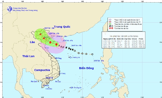 |
| Images showing the path of Typhoon No. 1. |
According to the latest information from the North Central Meteorological and Hydrological Station, early this morning (July 27),Typhoon No. 1 has passed Hainan Island and entered the Gulf of Tonkin.
At 8:00 AM on July 27thThe storm's center is located at approximately 19.5 degrees North latitude and 108.5 degrees East longitude, 230km southeast of the coast of Thai Binh and Ninh Binh provinces. The strongest winds near the storm's center are at level 8-9 (60-90km/h), with gusts up to level 9-10.
Forecast for the next 12 hoursThe storm is moving in a west-northwest direction at a speed of approximately 15-20 km/h. By 7 PM on July 27th, the storm's center was located at approximately 20.0 degrees North latitude and 107.0 degrees East longitude, over the sea off the coast of Hai Phong and Thanh Hoa provinces. The strongest winds near the storm's center were at force 8-9 (60-90 km/h), with gusts up to force 10-11.
Due to the influence of the storm, the Gulf of Tonkin (including the island districts of Bach Long Vi, Cat Hai, Co To, and Van Don) will experience strong winds of force 6-7, with winds near the storm's center reaching force 8-9, gusting to force 10-11. The sea will be very rough. Disaster risk level: level 3.
Forecast for the next 12-24 hoursThe storm is moving northwest at a speed of approximately 15-20 km/h. Therefore, tonight and tomorrow night, the storm's center will enter the territory of the Northern Delta provinces, then weaken into a tropical depression. By 7:00 AM on July 28th, the center of the tropical depression will be located at approximately 21.0 degrees North latitude; 105.4 degrees East longitude, over the Northern Delta region. The strongest winds near the center of the tropical depression will be at level 6 (40-50 km/h), with gusts at levels 7-8.
Over the next 24 to 36 hoursThe tropical depression moved northwest at approximately 15 km/h, penetrating further inland and weakening into a low-pressure area. By 7 PM on July 28th, the center of the low-pressure area was located at approximately 22.0 degrees North latitude and 104.5 degrees East longitude, over the mountainous provinces of northern Vietnam. The strongest winds at the center of the low-pressure area decreased to below level 6 (below 40 km/h).
Weather forecast for the North Central region on July 27th, day and night:
At sea: Strong winds are gradually increasing to level 6-7, sometimes level 8, with gusts of level 9-10. The sea is very rough. Disaster risk level: level 3.
* On landFrom today (July 27th) until the end of July 28th, Thanh Hoa and northern Nghe An will experience moderate to heavy rain, with some areas experiencing very heavy rain and thunderstorms. (Be aware of the risk of flash floods and landslides in mountainous areas, and flooding in low-lying areas); Southern Nghe An and Ha Tinh will have rain, with some areas experiencing moderate to heavy rain and thunderstorms (during thunderstorms, be aware of strong winds, gusts, and tornadoes).
Ha Chi

