Satellite images accuse China of breaking its promise and continuing to militarize the East Sea.
Satellite images show that China continues illegal construction activities on some reefs in the East Sea, contrary to the non-militarization commitment made by the country's president.
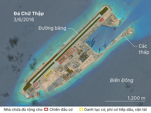 |
Satellite photo of Cross Reef on June 3. Photo: CSIS. |
Chinese President Xi Jinping during a meeting with US President Barack Obama at the White HouseSeptember 2015 has beenreassure the US about China's intentions toward the Spratly Islands.“China has no intention of pursuing militarization,” Mr. Xi said.
However, recent satellite images suggest China has a different plan. The photos, collected and studied by the Center for Strategic and International Studies (CSIS) in Washington, show construction activity suspected to be renovating aircraft hangars on Fiery Cross, Subi and Mischief Reefs.
No military aircraft were visible at the time of the photo, but CSIS said the hangars on the three reefs were large enough to accommodate "any fighter jet of the People's Liberation Army (PLA) Air Force," the New York Times reported.
The larger hangars on the reefs can accommodate H-6 bombers, H-6U tankers, Y-8 transport aircraft and a KJ200 Airborne Early Warning and Control System (AWACS) aircraft.
China may justify these structures as accommodating civilian aircraft or other non-military functions, but satellite imagery suggests otherwise, according to CSIS. The smallest hangars are 18 to 21 meters wide, more than enough to accommodate China’s largest fighter jets. In addition to size, there are signs of structural reinforcement.
“They are much thicker for civilian use,” Gregory B. Poling, director of the Asia Maritime Transparency Initiative (AMTI), CSIS, said yesterday. “They are reinforced to be able to withstand attack.”
The largest hangar, 61 meters wide, is “more than capable of handling bombers and tankers,” Poling added. If deployed, these aircraft would complicate disputes between China and the Philippines and other countries in the region, adding to the risk of US “freedom of navigation” patrols in the area.
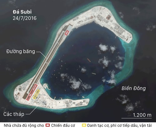 |
Satellite photo of Subi Reef on July 24. Photo: CSIS. |
Even before the hangars appeared, independent military analysts said China wanted to use the "artificial islands" to demonstrate military power in the region.
“We knew from the day they started building the runway,” Mr. Poling said. “The Chinese claiming they have good intentions is like saying, ‘Build a whole mansion but only on the first floor.’”
Evidence of the military hangar emerged a month after the Permanent Court of Arbitration in The Hague, Netherlands, condemned China's actions in the South China Sea, including illegally reclaiming rocks in the area into artificial islands and then building on them.
The ruling was the result of a case brought by the Philippines against China before the Permanent Court of Arbitration. China has said it will ignore the ruling. Some analysts note that the hangars were not a response to the ruling and appear to have been built before then.
“The foundation could have been laid months ago,” said M. Taylor Fravel, a professor of political science at the Massachusetts Institute of Technology and a member of the institute’s Security Studies Program.
Mr Fravel said the hangars contradicted the Chinese president’s assertions. “China has given itself the option of using these reefs as military facilities but has not yet decided to what extent,” he said.
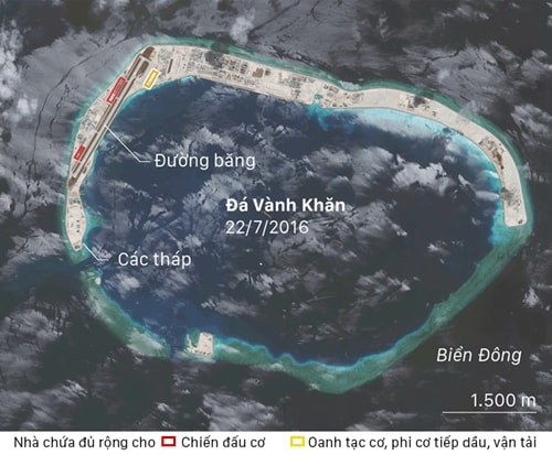 |
Satellite photo of Vành Khăn Reef on July 22. Photo: CSIS. |
According to VNE
| RELATED NEWS |
|---|


