
Tropical depression is heading towards the Paracel Islands.
Currently, the strongest winds in the area near the center of the tropical depression are at level 6 or 7 (i.e., from 39 to 61 km per hour), with gusts at level 8 or 9.
At 1:00 AM on June 21st, the center of the tropical depression was located at approximately 17.6 degrees North latitude and 117.3 degrees East longitude, about 550km east-northeast of the Hoang Sa (Paracel) Islands. The strongest winds near the center of the tropical depression were at force 6-7 (39 to 61 km per hour), with gusts of force 8-9.
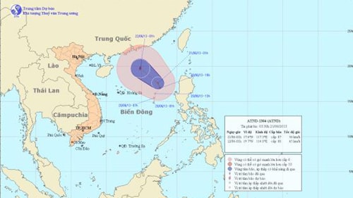
Location and movement direction of the tropical depression
The forecast for the next 24 hours indicates that the tropical depression will move in a direction between north-northwest and northwest, traveling at approximately 10-15 km per hour, and has the potential to strengthen into a typhoon.
At 1:00 AM on June 22nd, the typhoon's center was located at approximately 19.7 degrees North latitude and 114.8 degrees East longitude, about 410 km northeast of the Hoang Sa (Paracel) Islands. The strongest winds near the center of the typhoon were at level 8 (62 to 74 km per hour), with gusts at levels 9 and 10.
Due to the influence of the tropical depression, the northern part of the East Sea (including the sea area east of the Hoang Sa archipelago) will experience strong winds of force 6-7, later increasing to force 8, gusting to force 9-10, along with heavy rain and thunderstorms. The sea will be rough. Tornadoes should be anticipated during thunderstorms.
Furthermore, due to the influence of a strong southwest wind zone, the sea areas from Binh Thuan to Ca Mau, from Ca Mau to Kien Giang, the Gulf of Thailand, and the central and southern parts of the East Sea (including the sea area around the Spratly Islands) will experience strong southwest winds of force 5, sometimes force 6, gusting to force 7, with heavy rain and thunderstorms. The sea will be rough. During thunderstorms, be wary of tornadoes and strong gusts of wind.
According to (vov.vn) - LT


