Tropical depression strengthens into storm, Nghe An issues urgent dispatch to respond
(Baonghean.vn) - Forecast, the strongest wind near the storm center is level 8, gusting to level 10.
According to the bulletin from the National Center for Hydro-Meteorological Forecasting, on the evening of June 12, the tropical depression in the North East Sea strengthened into a storm (storm No. 1, international name NURI). At 4:00 a.m. on June 13, the center of the storm was at about 17.8 degrees North latitude; 116.0 degrees East longitude, about 380km East Northeast of Hoang Sa archipelago. The strongest wind near the center of the storm was at level 8, gusting to level 10. It is forecast that in the next 24 hours, the storm will move in a northwest direction, traveling about 20-25km per hour and is likely to strengthen. At 4:00 a.m. on June 14, the center of the storm was at about 21.2 degrees North latitude; 112.1 degrees East longitude, right on the sea south of Quang Ninh province.
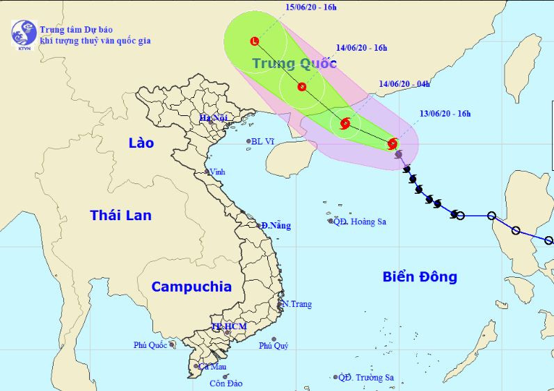 |
| Expected path of storm No. 1. Photo: National Center for Hydro-Meteorological Forecasting. |
To proactively respond to the storm's developments, the Standing Office of the Provincial Steering Committee for Disaster Prevention and Control requests the Chairman - Head of the Steering Committee for Disaster Prevention and Control of the districts: Quynh Luu, Dien Chau, Nghi Loc, Towns: Cua Lo and Hoang Mai; Provincial Military Command; Provincial Border Guard Command; Departments: Transport, Natural Resources and Environment, Agriculture and Rural Development, Information and Communications and related units to implement the following contents: Strictly implement the telegram: No. 01/CD-TW of the Central Steering Committee for Natural Disaster Prevention and Control - National Committee for Incident Response, Natural Disasters and Search and Rescue.
Regularly update information, promptly notify owners of vehicles and captains of ships operating at sea of the location and developments of the storm to proactively avoid, escape or not enter the dangerous area. The dangerous area in the East Sea in the next 24 hours due to the influence of the storm from the East of longitude 110.0 degrees East; from latitude 16.0 degrees North to 22.0 degrees North and will be adjusted in the next bulletins of the forecasting agency.
The Department of Natural Resources and Environment directed the North Central Region Hydrometeorological Station to continue providing timely and accurate forecasts of storm-affected areas so that authorities and people can proactively respond.
