
Tropical depression in the East Sea intensifies
The strongest winds in the area near the center of the tropical depression are at level 6 or 7, with gusts reaching level 8 or 9.
At 7 PM on July 16th, the center of the tropical depression was located at approximately 16.3 degrees North latitude and 123.5 degrees East longitude, 160 km east of Ludong Island (Philippines). The strongest winds near the center of the tropical depression were at force 6 or 7 (39-61 km/h), with gusts of force 8 or 9.
Forecast for the next 24 hours: The tropical depression will move mainly northwest at a speed of approximately 15-20 km/h and is likely to intensify. By 7 PM on July 17th, the center of the tropical depression will be located at approximately 19.4 degrees North latitude; 120.4 degrees East longitude, over the sea northwest of Ludong Island (Philippines). The strongest winds near the center of the tropical depression will be at level 7 (50-61 km/h), with gusts at levels 8 and 9.
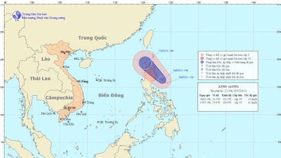
The path of the tropical depression.
Due to the influence of the tropical depression, from July 17th, the northeastern sea area of the North East Sea will experience increasingly strong winds of level 6, level 7, gusting to level 8, level 9, and heavy rain and thunderstorms. The sea will be rough.
Furthermore, due to the strong southwest monsoon, the sea area from Binh Thuan to Ca Mau and the southern South China Sea (including the Truong Sa archipelago) will experience strong southwest winds of force 6, gusting to force 7 and 8; rough seas. The sea areas from Binh Thuan to Ca Mau, Ca Mau to Kien Giang, the Gulf of Thailand, and the central and southern South China Sea (including the Truong Sa archipelago) will experience heavy rain and thunderstorms. During thunderstorms, be wary of possible tornadoes and strong gusts of wind.
According to (vov.vn) - LT


