Strong storm level 8 is about to enter the East Sea
(Baonghean.vn) - On the afternoon of October 20, storm Saudel with winds of 75 km/h (level 8) was about 200 km from Luzon Island, Philippines, and is expected to enter the East Sea tonight.
National Center for Hydro-Meteorological Forecastingsaid that tonight and tomorrow the storm will move in the West Northwest direction, moving 20-25 km per hour, entering the East Sea and becoming the 8th storm of this year's rainy and stormy season.
By 1 p.m. tomorrow, the storm center will be about 650 km from Hoang Sa archipelago, with the strongest wind speed of 90 km/h, level 8-9, gusting up two levels.
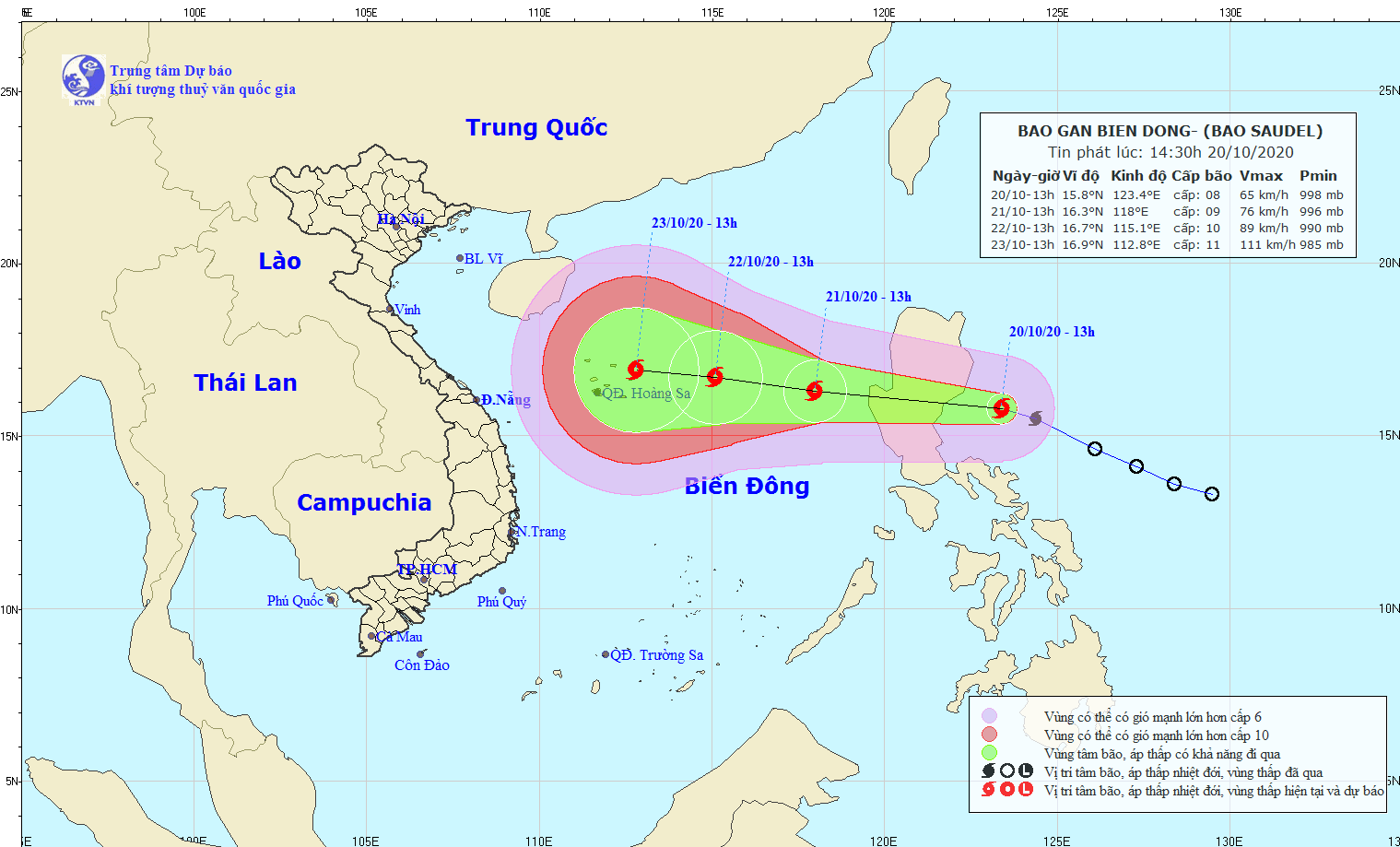 |
| Forecast of the path and affected area of storm Saudel. Photo: NCHMF. |
In the next two days, the storm will move westward at 15-20 km per hour and is likely to strengthen. At 1 pm on October 22, the storm center will be about 280 km east-southeast of the Hoang Sa archipelago, with the strongest winds of 100 km/h, level 10.
Mr. Tran Quang Nang, Head of Weather Forecasting Department, National Center for Hydro-Meteorological Forecasting, said that when reaching Hoang Sa archipelago, the storm will move slower, its intensity and trajectory will change. It is very likely that the storm will directly affect the Central region on October 24, causing rain in provinces from the southern part of the Northern Delta to the North and Central Central regions.
Japanese radio said that this afternoon, the strongest wind speed of typhoon Saudel is 65 km/h, today it will enter the East Sea, by October 23 it will reach 111 km/h. Hong Kong radio forecasts that when the storm enters central Vietnam, when in the middle of the East Sea, the wind speed will reach a maximum of 120 km/h, then gradually decrease.
Dangerous areas due to storms aboveEast Seain the next 24 hours (strong wind level 6, gusting from level 8 or higher) from latitude 14.5 to 18; from longitude 116 to 120. Ships operating in the danger zone are at high risk of being affected by strong gusts of wind.
In the past 2 weeks, the East Sea has appeared 2tropical depressionand two storms, both affecting Vietnam, causing heavy rains, floods, and landslides. All developed from low-lying cyclones within the tropical convergence zone connecting the Bay of Bengal, across the Central region and to the Philippine Sea.
Statistics as of October 19 showed that the number of deaths due to floods in 10 provinces in the Central and Central Highlands regions was 102, and the number of missing people was 26.
