Typhoon Melor is approximately 170km off the coast of the Philippines.
According to the National Center for Hydro-Meteorological Forecasting: At 1:00 AM on December 14th, the center of Typhoon Melor was located approximately 170km east of the central coast of the Philippines.
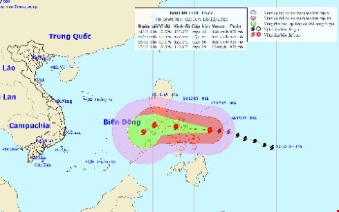 |
| The path of the storm. |
The strongest winds in the area near the center of the storm reached level 13 (i.e., 135 to 150 km/h), with gusts of level 16-17.
The forecast for the next 24 hours indicates the storm will move mainly westward, at a speed of approximately 20 km per hour.
As of 1:00 AM on December 15th, the storm's center was located over central Philippines. The strongest winds near the storm's center reached levels 12-13 (120-150 km/h), with gusts up to levels 14-15.
Over the next 24 to 48 hours, the storm will continue to move westward at a speed of approximately 10-15 km per hour.
As of 1:00 AM on December 16th, the storm's center was located over the western part of central Philippines. The strongest winds near the storm's center were at level 10-11 (90 to 120 km/h), with gusts reaching level 13-14.
Due to the influence of Typhoon Melor's circulation, the eastern part of the central South China Sea is experiencing heavy rain and thunderstorms, with strong winds of force 6-7, near the center of the typhoon force 9-10, gusting to force 11-12. The sea is very rough.
Over the next 48 to 72 hours, the storm is likely to change direction, moving west-southwest at a speed of approximately 5-10 km per hour.
According to VOV
| RELATED NEWS |
|---|

