Storm Noru is approaching the East Sea
Storm Noru, with winds of level 10-11, is moving westward and is forecast to enter the East Sea in the coming days.
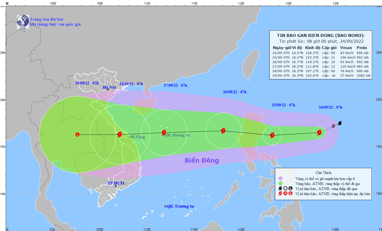 |
Forecast track of typhoon Noru. |
At 7:00 a.m. on September 24, the center of the storm is located at about 16.5 degrees North latitude; 128.3 degrees East longitude, about 710km east of Luzon Island (Philippines). The strongest wind near the center of the storm is level 9 (75-88km/hour).level 11.
Forecast for the next 24 hours,The storm is moving mainly in the West-Southwest direction, traveling about 20km per hour and gradually strengthening. At 7:00 a.m. on September 25, the center of the storm was at about 16.2 degrees North latitude; 123.3 degrees East longitude, about 130km east of Luzon Island (Philippines). The strongest wind near the center of the storm is level 10-11 (89-117km/hour).level 14.
In the next 24 to 48 hours,The storm moved in the West-Northwest direction, traveling 20-25km per hour and entered the East Sea. At 7:00 a.m. on September 26, the center of the storm was at about 16.7 degrees North latitude; 118.1 degrees East longitude, in the sea area east of the North East Sea, about 650km east of the Hoang Sa archipelago. The strongest wind near the center of the storm was level 9-10 (75-102km/hour).level 13.
Over the next 48 to 72 hours,The storm is moving rapidly westward, at about 30km per hour, with a tendency to strengthen. At 7am on September 27, the storm's center was at about 16.5 degrees North latitude; 111.8 degrees East longitude, in the Hoang Sa archipelago. The strongest wind near the storm's center is level 11-12 (103-133km/hour).level 15Due to the influence of the storm, from around the afternoon of September 25, in the eastern sea area of the North and the middle of the East Sea, the wind will gradually increase to level 6-7, near the center of the storm it will be level 8-9, gusting to level 11; waves will be 4.0-6.0m high; the sea will be rough.
Disaster risk warning level in the eastern sea area of the North and Central East Sea: level 3.
In 72 to 120 hours,The storm continues to move rapidly, mainly in a westerly direction, at 20-25km per hour, gradually weakening in intensity, and is likely to affect the Central region./.