Storm Noru with level 14 gusts has entered the East Sea
Early this morning (September 26), storm Noru passed the southern area of Luzon Island (Philippines), entered the East Sea, becoming storm number 4 in 2022.
4 o'clock, the storm center is located at about 15.6 degrees North latitude; 119.5 degrees East longitude, in the sea west of Luzon Island (Philippines), about 810km east of Hoang Sa archipelago.The strongest winds near the eye of the stormlevel 12-13 (118-149km/h), gusts level 14. Radius of strong winds from level 6, gusts from level 8 or higher is about 230km from the center of the storm; radius of strong winds from level 10, gusts from level 12 or higher is about 100km from the center of the storm.
Forecast for the next 24 hours,The storm is moving mainly in the West-Northwest direction, traveling 20-25km per hour, entering the East Sea. At 4:00 a.m. on September 27, the center of the storm was at about 15.9 degrees North latitude; 114.6 degrees East longitude, about 250km East-Southeast of the Hoang Sa archipelago. The strongest wind near the center of the storm is level 13 (134-149km/hour).
Dangerous areas in the East Sea in the next 24 hours (strong winds from level 6 or higher, gusts from level 8 or higher):from latitude 12.5 to 20.0 degrees North; east of longitude 111.5 degrees East. All vessels operating in the danger zone are at high risk of being affected by strong winds, large waves and whirlwinds.Disaster risk level: level 3.
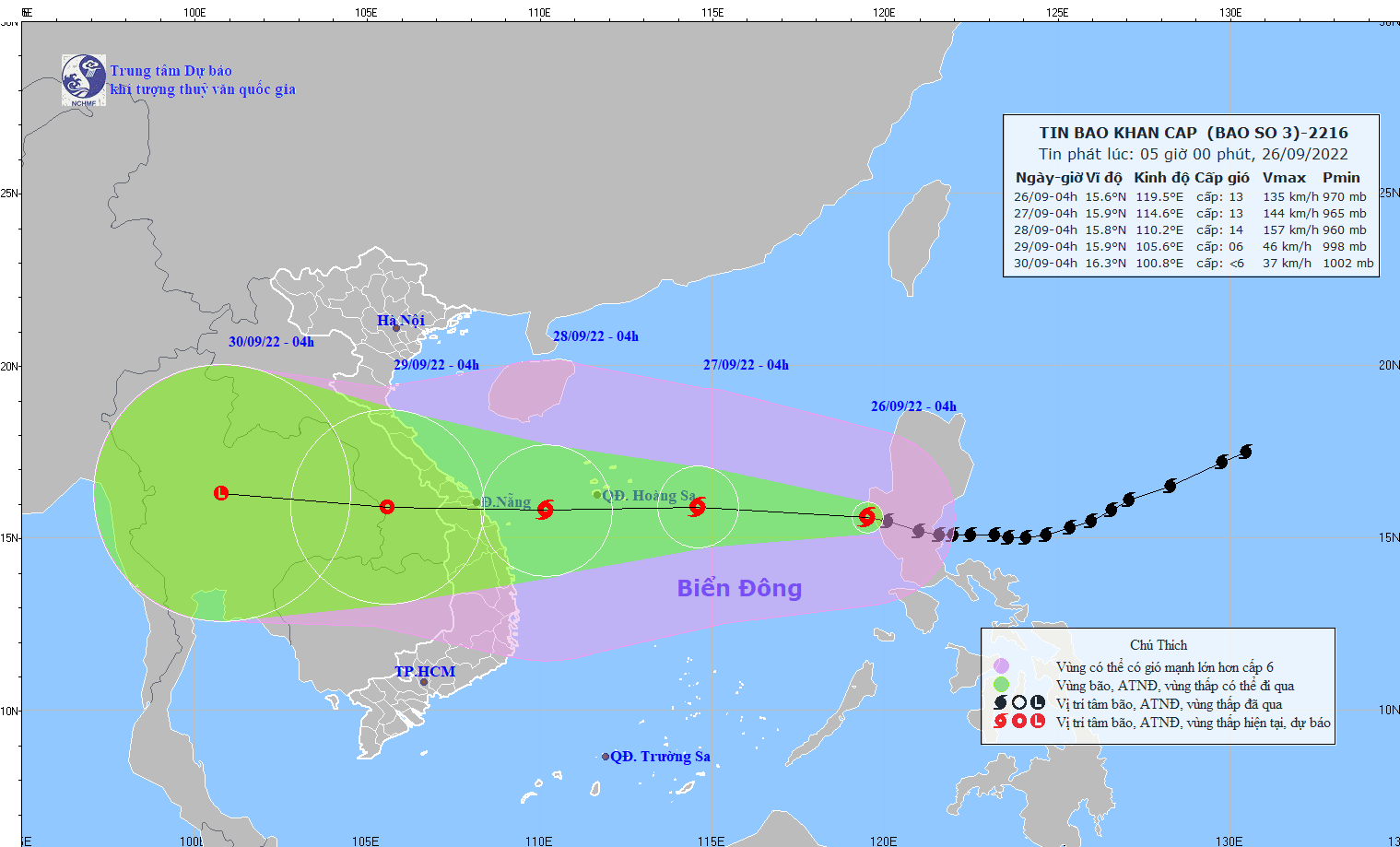 |
The path of storm No. 4. Photo: National Center for Hydro-Meteorological Forecasting |
In the next 24 to 48 hours,The storm is moving mainly in a westerly direction, traveling 20-25km per hour and has a tendency to strengthen. At 4:00 a.m. on September 28, the center of the storm was at about 15.8 degrees North latitude; 110.2 degrees East longitude, about 170km east of the mainland of Da Nang-Binh Dinh. The strongest wind near the center of the storm is level 13-14 (134-166km/hour).jerky17.
Dangerous areas at sea in the next 24 to 48 hours (strong winds from level 6 or higher, gusts from level 8 or higher):From latitude 12.0 to 20.0 degrees North; west of longitude 118.0 degrees East. All vessels and activities in the danger zone are at high risk of being affected by strong winds, large waves and tornadoes.Disaster risk level: level 3.
Over the next 48 to 72 hours,The storm moved mainly in a westerly direction, traveling 20-25km per hour, entering the mainland of the Central Central region, gradually weakening into a tropical depression. At 4:00 a.m. on September 29, the center of the tropical depression was at about 15.9 degrees North latitude; 105.6 degrees East longitude, in the area over southern Laos. The strongest wind near the center of the tropical depression was level 6 (39-49km/hour).level 8 jerk.
During the next 72 to 96 hours,The tropical depression moves mainly to the West at a speed of 20-25km/h, weakening and gradually dissipating.
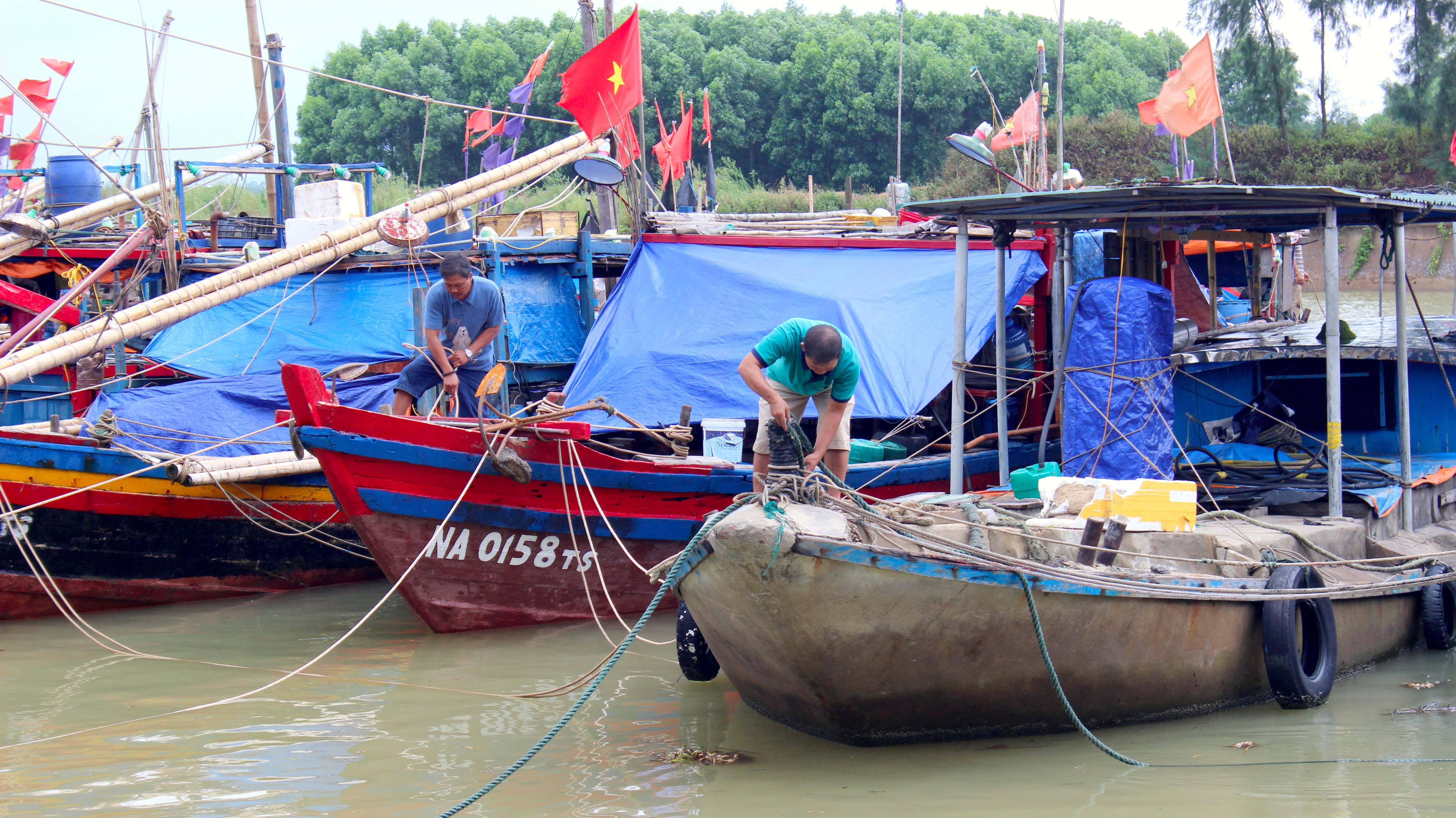 |
Nghe An fishermen anchor their boats to avoid the storm. Photo: Quang An |
Warning of strong winds, big waves at sea, storm surge in coastal areas:The sea area south of the North East Sea (including the sea area of Hoang Sa archipelago), the central East Sea area has storms and rain, strong winds of level 8-9, then increasing to level 10-11; the area near the storm center is level 12-14,level 17; waves 8-10m high; rough seas. From noon on September 27, the sea off the coast of the area from Quang Binh to Ninh Thuan (including Con Co, Cu Lao Cham, and Ly Son island districts) had strong winds of level 8-9, then increasing to level 10-11, near the storm center strong winds of level 12-14, gusts of level 17, waves 8-10m high, rough seas.
From the evening and night of September 27, coastal waters from Thua Thien Hue to Binh Dinh will have waves 3-5m high, and 6-8m near the storm center. Areas from Quang Tri to Quang Ngai need to be on guard against storm surges of 1.0-1.5m high, causing flooding in low-lying coastal and river mouth areas. All boats, aquaculture areas and activities in the above sea areas are at high risk of being affected by strong winds, big waves, whirlwinds and storm surges.
Strong wind warning on land:From early morning on September 28, coastal areas from Quang Tri to Ninh Thuan will have strong winds of level 6, then increasing to level 7-8, gusting to level 9-10; coastal areas of Da Nang, Quang Nam, Quang Ngai, Binh Dinh, from early morning on September 28, will have strong winds of level 9-10, areas near the storm center will have strong winds of level 11-12, gusting to level 14-15, areas further inland will have strong winds of level 8-9; gusting to level 12-13; Kon Tum and Gia Lai areas on September 28 will have winds gradually increasing to level 6, then increasing to level 7-8, in some places level 9, gusting to level 11.
Heavy rain warning:From the afternoon of September 27 to September 28, in the Central Central region and the North Central Highlands, there will be heavy to very heavy rain, thunderstorms with strong gusts of wind, with rainfall ranging from 150-300mm, with some places experiencing over 350mm. From September 28 to 30, the rain will tend to spread to the North Central region.
Disaster risk level:Da Nang, Quang Nam, Quang Ngai, Binh Dinh:Level 4
Quang Tri, Thua Thien Hue, Phu Yen, Kon Tum, Gia Lai:Level 3.
(According to the National Center for Hydro-Meteorological Forecasting).