
Typhoon Rammasun, a Category 10 storm, continues to head towards the East Sea.
On the morning of July 14th, Typhoon Rammasun, with winds reaching level 10 and gusts up to level 11, continued heading towards the East Sea.
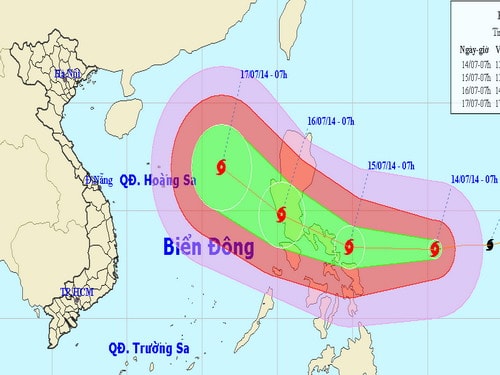 |
Forecast of the path of Typhoon Rammasun - Photo: Central Meteorological and Hydrological Forecasting Center, updated at 9:00 AM on July 14.
According to the National Center for Hydro-Meteorological Forecasting, at 7:00 AM on July 14th, the typhoon's center was located at approximately 13.2 degrees North latitude and 130.5 degrees East longitude, about 1,000 km east-southeast of Luzon Island (Philippines). The strongest winds near the center of the typhoon reached level 10 (89 to 102 km/hour), with gusts of level 11 and 12.
Forecasts indicate that over the next 24 hours, the storm will move mainly westward at a speed of approximately 25 km per hour and will continue to intensify. By 7:00 AM on July 15th, the storm's center will be located at approximately 13.3 degrees North latitude and 124.8 degrees East longitude, off the eastern coast of central Philippines.
The strongest winds in the area near the center of the storm reached level 12 (i.e., from 118 to 133 km/h), with gusts reaching levels 14 and 15.
Due to the influence of the storm's circulation, from the night of July 15th, the eastern part of the South China Sea will experience increasingly strong winds, reaching levels 7 and 8, with winds near the storm's center reaching levels 9 and 10, gusting to levels 11 and 12. The sea will be very rough.
According to Thanh Nien newspaper


