
Typhoon No. 1 formed over the East Sea.
At 8:00 AM on June 21st, the center of Typhoon No. 1 was located directly over the sea area of the Hoang Sa archipelago.
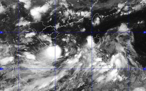 |
| (Photo: National Center for Hydro-Meteorological Forecasting) |
According to the National Center for Meteorological and Hydrological Forecasting: This morning (June 21), the tropical depression strengthened into a typhoon with the international name KUJIRA. This is the first typhoon of 2015 in the East Sea.
At 8:00 AM on June 21st, the center of Typhoon No. 1 was located at approximately 16.0 degrees North latitude and 111.7 degrees East longitude, right over the sea area of the Hoang Sa (Paracel) Islands. The strongest winds near the center of the typhoon were at level 8 (approximately 60 to 75 km per hour), with gusts of level 9-10.
The forecast for the next 24 hours indicates the storm will move northward at a speed of 5-10 km per hour. By 7:00 AM on June 22nd, the storm's center will be located at approximately 18.0 degrees North latitude and 111.2 degrees East longitude, about 190 km north-northwest of the Hoang Sa (Paracel) Islands. The strongest winds near the storm's center will be at force 8 (approximately 60-75 km per hour), with gusts of force 9-10.
Due to the influence of the storm, the sea area around the Hoang Sa archipelago is experiencing strong winds of force 6-7, reaching force 8 near the storm's center, with gusts of force 9-10, and waves 3-5 meters high. The sea is rough. Disaster risk level: level 3.
Over the next 24 to 48 hours, the storm will move in a North-Northwest direction at approximately 10 km per hour. By 7:00 AM on June 23rd, the storm's center will be located at approximately 20.1 degrees North latitude and 110.5 degrees East longitude, north of Hainan Island (China). The strongest winds near the storm's center will be at force 8-9 (approximately 60 to 90 km per hour), with gusts reaching force 10-11.
Due to the influence of the storm, the sea area north of the Hoang Sa archipelago is experiencing strong winds of force 6-7, reaching force 8 near the storm's center, with gusts of force 9-10, and waves 3-5 meters high. The sea is rough. Disaster risk level: level 3.
Over the next 48 to 72 hours, the storm will continue to move in a north-northwest direction, traveling at approximately 10 km per hour and gradually weakening.
Furthermore, due to the combined influence of the strong Southwest monsoon, the central and southern areas of the South China Sea (including the waters around the Spratly Islands), and the coastal waters of provinces from Binh Thuan to Ca Mau will experience strong Southwest winds of force 6, gusting to force 7-8, along with heavy rain and thunderstorms. Sea waves will be 2-4 meters high. The sea will be rough. Tornadoes are possible during thunderstorms.
According to VOV