Typhoon No. 1 will make landfall in Quang Ninh.
From the evening of June 23rd, the Quang Ninh province area experienced increasingly strong winds, reaching levels 6-7, with gusts up to levels 8-9.
At 4:00 AM on June 23rd, the center of the storm was located at approximately 19.5 degrees North latitude and 109.7 degrees East longitude, over the mainland of Hainan Island, about 320km southeast of Mong Cai (Quang Ninh). The strongest winds near the center of the storm were at level 8 (approximately 60-75 km/h), with gusts of level 9-10.
Forecasts indicate that over the next 12 hours, the storm will move northwest at a speed of approximately 10-15 km/h. Therefore, this morning (June 23rd), the storm's center will enter the northeastern part of the Gulf of Tonkin. By 4 PM on June 23rd, the storm's center will be located at approximately 20.5 degrees North latitude and 108.9 degrees East longitude, about 180 km southeast of Mong Cai (Quang Ninh). The strongest winds near the storm's center will be at level 8 (approximately 60-75 km/h), with gusts reaching levels 9-10.
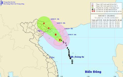 |
| The trajectory of Typhoon No. 1 |
Due to the influence of the storm, the northern part of the Gulf of Tonkin will experience strong winds of force 6-7, reaching force 8 near the storm's center, with gusts of force 9-10. The sea will be rough. Disaster risk level: level 3.
Over the next 12-24 hours, the storm will move northwest at approximately 10-15 km/h, making landfall and gradually weakening into a tropical depression. By 4:00 AM on June 24th, the center of the tropical depression will be located at approximately 21.7 degrees North latitude and 107.6 degrees East longitude, near the Vietnam-China border. The strongest winds near the center of the tropical depression will be at level 6 (approximately 40-50 km/h), with gusts of level 7-8.
From the evening of June 23rd, the Quang Ninh province area experienced increasingly strong winds, reaching levels 6-7, with gusts up to levels 8-9; the provinces/cities of Hai Phong, Bac Giang, and Lang Son experienced wind gusts of levels 7-8. The level of natural disaster risk is level 3.
In Northern Vietnam, there will be rain, moderate rain, and heavy rain in some areas; particularly in the Northeast and mountainous/midland regions of Northern Vietnam, there will be heavy to very heavy rain. A flood surge with a water level increase of 2-3 meters is possible on rivers and streams in the northern mountainous areas. There is a high risk of flash floods, landslides, and mudslides in the provinces of Quang Ninh, Lang Son, Cao Bang, Bac Can, Bac Giang, Thai Nguyen, Phu Tho, Tuyen Quang, and Ha Giang. Level of natural disaster risk: Level 1.
Over the next 24-36 hours, the tropical depression will move northwest at a speed of approximately 10-15 km per hour, moving further inland and weakening into a low-pressure area. By 4 PM on June 24th, the center of the low-pressure area will be located at approximately 22.6 degrees North latitude and 106.7 degrees East longitude, over the mountainous region of Cao Bang. The strongest winds at the center of the low-pressure area will decrease to below level 6 (i.e., below 40 km per hour).
Moderate to heavy rainfall, and even very heavy rain, will continue in the Northeast and mountainous/midland areas of Northern Vietnam.
According to VOV.VN

