Typhoon No. 2 will enter the Gulf of Tonkin tonight, bringing heavy rain to the North.
Typhoon No. 2 (Prapiroon) is moving rapidly. After crossing Hainan Island (China), it is forecast to enter the Gulf of Tonkin tonight (July 22) and early tomorrow morning. From tonight onwards, heavy rain is expected in the Northern region and Thanh Hoa province.
According to the National Center for Hydro-Meteorological Forecasting, at 4:00 AM this morning (July 22), the center of Typhoon No. 2 (Parapiron) was located over Hainan Island (China). The strongest winds near the center of the typhoon reached level 9 (75-88 km/h), with gusts up to level 11, moving northwest at a speed of approximately 15 km/h.
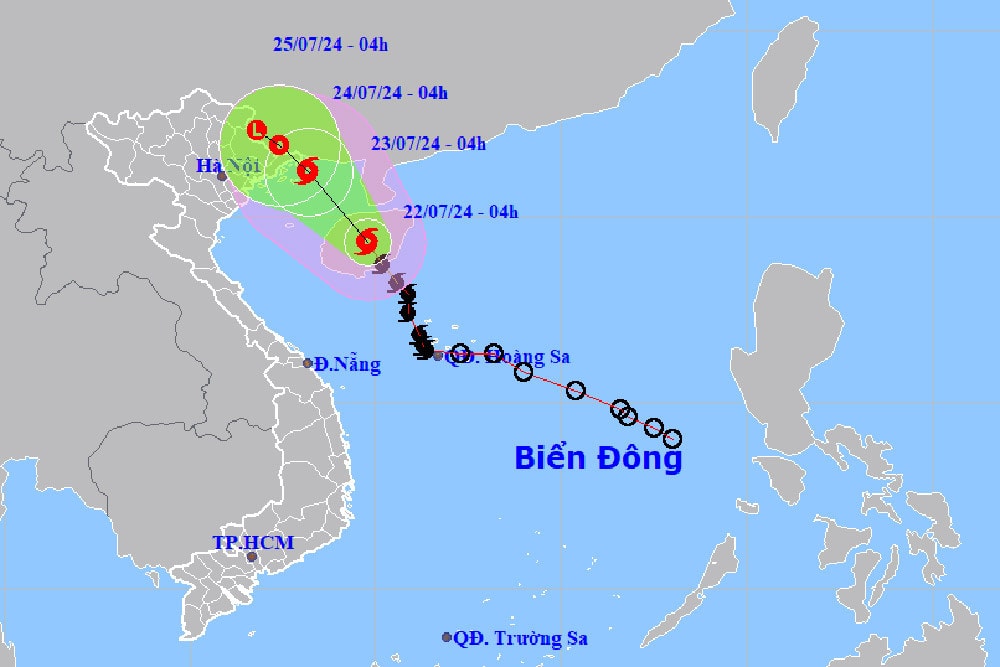
Forecasts for the next 24 hours indicate the storm will maintain its direction of movement at a speed of 10-15 km/h and enter the Gulf of Tonkin. By 4:00 AM on July 23rd, the storm's center will be located in the Gulf of Tonkin with a strength of level 8, gusting to level 10. The areas affected by Typhoon No. 2 include the northwestern part of the North East Sea and the northern part of the Gulf of Tonkin.
Over the next 24 hours, the storm continued to move northwest, slowing down to 5-10 km/h. By 4:00 AM on July 24th, the storm's center was located over land in southern Guangxi Province (China), with a strength of level 6 and gusts of level 8.
At approximately 4:00 AM on July 25th, the storm moved west-northwest at a speed of about 5 km/h and weakened into a low-pressure area over land in southern Guangxi province, with an intensity below level 6.
Due to the impact of Typhoon No. 2, the northwestern sea area of the North East Sea experienced strong winds of force 6-7 this morning (July 22), with winds near the center of the typhoon reaching force 8, gusting to force 10, and rough seas; wave heights were 2-4m. The northern Gulf of Tonkin (including Bach Long Vi and Co To islands) experienced gradually increasing winds of force 6-7, with winds near the center of the typhoon reaching force 8, gusting to force 10, and rough seas; wave heights gradually increased to 2-4m, reaching 1.5-2.5m along the coast of Quang Ninh province.
On land, from early morning on July 23rd, the coastal areas of Quang Ninh province are likely to be affected by strong winds of level 6, gusting to level 8.
From tonight until July 24th, moderate to heavy rain and thunderstorms are likely to occur in the Northern region and Thanh Hoa, with localized areas experiencing very heavy rain. Total rainfall in the coastal areas of the Northern region and the Northeast of the Northern region is expected to be 100-200mm, with some areas exceeding 250mm; other areas in the Northern region and Thanh Hoa will receive 50-100mm, with some areas exceeding 150mm.
The meteorological agency warns of the risk of flash floods and landslides in mountainous areas and flooding in low-lying areas and urban centers. During thunderstorms, there is a possibility of tornadoes, lightning, hail, and strong gusts of wind.
Previously, on July 21st, the Prime Minister issued a directive requesting ministers and chairmen of provincial and city People's Committees to promptly and effectively implement measures to respond to storms and floods in order to ensure the safety of lives and minimize property damage for the people.

