
Typhoon No. 2, with gusts reaching level 16, is now only 300 km away from the Paracel Islands.
According to the Central Meteorological and Hydrological Forecasting Center, at 13:00 on July 17th, the center of Typhoon No. 2 (international name Rammasun) was located at approximately 16.8 degrees North latitude and 115.0 degrees East longitude, about 300 km east of the Hoang Sa (Paracel) Islands. The strongest winds near the center of the typhoon reached level 13 (134 to 149 km/hour), with gusts of level 15 and 16.
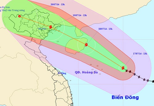 |
The trajectory of Typhoon No. 2 - Photo: Central Meteorological and Hydrological Forecasting Center, released at 2:30 PM on July 17.
The forecast for the next 24 hours indicates the storm will move in a direction between west-northwest and northwest, traveling at approximately 20-25 km per hour. By 13:00 on July 18th, the storm's center will be located at approximately 19.4 degrees North latitude and 110.9 degrees East longitude, off the eastern coast of Hainan Island (China). The strongest winds near the storm's center will reach levels 13 and 14 (i.e., 134 to 166 km/hour), with gusts reaching levels 16 and 17.
Over the next 24 to 48 hours, the storm will move in a direction between west-northwest and northwest, traveling at approximately 15-20 km per hour.
As of 13:00 on July 19th, the typhoon's center was located at approximately 21.4 degrees North latitude and 106.9 degrees East longitude, over the land of Quang Ninh and Hai Phong provinces. The strongest winds near the center of the typhoon reached level 10 (89 to 102 km/hour), with gusts of level 11 and 12.
Over the next 48 to 72 hours, the storm will move in a west-northwest direction, traveling at approximately 15-20 km per hour.
Due to the influence of the storm's circulation, the sea area between the northern and central parts of the East Sea (including the sea area around the Hoang Sa archipelago) will experience strong winds of force 10-12, with winds near the storm's center reaching force 13-14, gusting to force 16-17. The sea will be extremely rough.
From the evening of July 18th, the sea area of the Gulf of Tonkin (including the island districts of Bach Long Vi, Co To, Cat Hai, and Van Don) will experience increasingly strong winds, reaching level 8, then increasing to levels 9 and 10, and in the area near the storm's center, reaching levels 11 and 12, with gusts up to levels 14 and 15. The sea will be extremely rough, with waves reaching 5-6 meters in height.
From tomorrow night, coastal areas of provinces from Quang Ninh to Nam Dinh will experience increasingly strong winds, reaching levels 6-7, then increasing to levels 8-9, with winds near the storm's center reaching levels 10-11, gusting to levels 12-13. The northern delta provinces and the Northeast region will experience strong winds of levels 6-7, with some areas reaching level 8, gusting to level 9. Heavy to very heavy rain is expected in the northern and north-central provinces from tomorrow night. Mountainous areas in the North need to be prepared for flash floods and landslides.
The Central Meteorological and Hydrological Forecasting Center assessed this as a very strong storm, moving rapidly and with complex developments.
According to Thanh Nien newspaper


