Typhoon No. 2: The eye of the storm has strong winds of level 8 and 9.
At 10:00 AM on June 23rd, the center of the storm was located at approximately 19.8 degrees North latitude and 107.2 degrees East longitude, over the Gulf of Tonkin.
Due to the influence of the circulation of typhoon No. 2, provinces from Thanh Hoa to Quang Tri experienced moderate to heavy rain, with some areas receiving very heavy rainfall, generally ranging from 50 to 100mm; some places received even heavier rainfall such as Con Cuong (Nghe An): 113mm; Do Luong (Nghe An) 218mm; Hon Ngu (Nghe An) 215mm; Vinh City 214mm; Thach Dong (Ha Tinh) 239mm; Ha Tinh City 266mm….
In the coastal provinces of the Northeast and North Central regions, strong winds of level 5, in some places level 6, with gusts exceeding level 6, were recorded; some areas experienced even stronger winds, such as Cua Ong (Quang Ninh) with gusts of 19 m/s (level 8); Bach Long Vi Island (Hai Phong) with winds of 17 m/s (level 7), gusting to 25 m/s (level 10); Van Ly (Nam Dinh) with gusts of 17 m/s (level 7); Thai Binh with gusts of 20 m/s (level 8); Hon Ngu (Nghe An) with gusts of 18 m/s (level 8)...
At 10:00 AM on June 23rd, the typhoon's center was located at approximately 19.8 degrees North latitude and 107.2 degrees East longitude, over the Gulf of Tonkin, about 100km southeast of the northeastern coast of Vietnam. The strongest winds near the center of the typhoon were at force 8 or 9 (62 to 88 km per hour), with gusts reaching force 10 or 11.
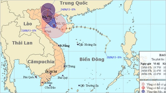
The storm's path (Image: National Center for Hydro-Meteorological Forecasting)
According to the Central Meteorological and Hydrological Forecasting Center: Due to the influence of the circulation of typhoon No. 2, moderate to heavy rain, and in some places very heavy rain, occurred in provinces from Thanh Hoa to Quang Tri, with rainfall amounts generally ranging from 30 to 60 mm; some places experienced even heavier rainfall such as Con Cuong (Nghe An): 113 mm; Do Luong (Nghe An) 178 mm; Hon Ngu (Nghe An) 188 mm; Vinh City 189 mm; Ha Tinh City 207 mm…
In the coastal provinces of the Northeast and North Central regions, strong winds of level 5, in some places level 6, with gusts exceeding level 6, were recorded; some areas experienced even stronger winds, such as Cua Ong (Quang Ninh) with gusts of 19 m/s (level 8); Bach Long Vi Island (Hai Phong) with winds of 17 m/s (level 7) and gusts of 25 m/s (level 10); Van Ly (Nam Dinh) with gusts of 17 m/s (level 7); Thai Binh with gusts of 20 m/s (level 8); Hon Ngu (Nghe An) with gusts of 18 m/s (level 8)...
At 7:00 AM on June 23rd, the center of the storm was located at approximately 19.7 degrees North latitude and 107.3 degrees East longitude, over the Gulf of Tonkin, about 130km southeast of the coast of the northeastern provinces of Vietnam. The strongest winds near the center of the storm were at level 8 or 9 (62 to 88 km per hour), with gusts reaching level 10 or 11.
The forecast for the next 24 hours indicates that the storm will move northwest, then gradually shift towards the north-northwest, traveling at approximately 10 km per hour, making landfall in the northeastern part of Vietnam and gradually weakening into a tropical depression.
As of 7:00 AM on June 24th, the center of the tropical depression was located at approximately 21.6 degrees North latitude and 106.1 degrees East longitude, over the northeastern provinces of Vietnam. The strongest winds near the center of the tropical depression were at level 6 (39 to 49 km per hour), with gusts up to level 7.
Over the next 24 to 36 hours, the tropical depression is likely to change direction, moving northward at approximately 10 km per hour, continuing inland and weakening into a low-pressure area.
As of 7 PM on June 24th, the center of the low-pressure area was located at approximately 22.6 degrees North latitude and 106.2 degrees East longitude, over the mountainous provinces of Northern Vietnam. The strongest winds at the center of the low-pressure area had decreased to below level 6 (i.e., below 39 km per hour).
Due to the influence of the storm, in the Gulf of Tonkin (including the island districts of Van Don, Co To, Cat Hai, and Bach Long Vi), there will be strong winds of force 6-7, near the storm's center force 8-9, gusting to force 11-12. The sea will be rough. Coastal areas of the northeastern provinces and Thanh Hoa will experience strong winds of force 6-7, near the storm's center force 8, gusting to force 10-11. Moderate to heavy rain, and in some places very heavy rain, is expected in the northern provinces and from Thanh Hoa to Quang Binh. Mountainous areas should be wary of flash floods and landslides.
According to (vov.vn) - LT

