
Typhoon No. 3 is approximately 310 km from the Hoang Sa archipelago.
The strongest winds in the area near the center of the storm are at force 9 (i.e., from 75 to 88 km per hour), with gusts reaching force 10 or 11.
According to the National Center for Hydro-Meteorological Forecasting, at 4:00 AM on July 1st, the typhoon's center was located at approximately 17.8 degrees North latitude and 115.0 degrees East longitude, about 310km east-northeast of the Hoang Sa (Paracel) Islands. The strongest winds near the center of the typhoon were at level 9 (75 to 88 km per hour), with gusts at levels 10 and 11.
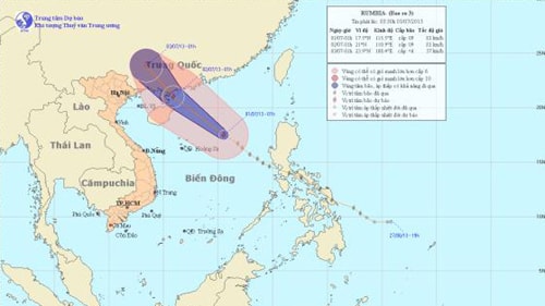
The direction and location of the storm.
The forecast for the next 24 hours indicates the storm will move in a direction between west-northwest and northwest, traveling at approximately 25 km per hour. By 4:00 AM on July 2nd, the storm's center will be located at approximately 21.5 degrees North latitude and 110.5 degrees East longitude, over the northeastern part of the Leizhou Peninsula (China). The strongest winds near the storm's center will be at force 9 (75 to 88 km per hour), with gusts reaching force 10 and 11.
Over the next 24 to 48 hours, the storm moved mainly northwest at a speed of about 20-25 km/h, making landfall in southeastern Guangxi Province (China) and gradually weakening into a tropical depression. The tropical depression then continued further inland and weakened into a low-pressure area.
By 4:00 AM on July 3rd, the center of the low-pressure area was located at approximately 24.3 degrees North latitude and 108.0 degrees East longitude, over land in the southeastern part of Guangxi province (China). The strongest winds at the center of the low-pressure area had decreased to below level 6 (i.e., below 39 km per hour).
Due to the influence of the storm, the northern South China Sea area (including the sea area east and north of the Hoang Sa archipelago) will experience strong winds of force 6-7, with winds near the storm's center reaching force 8-9, gusting to force 10-11. The sea will be very rough. From the morning of July 2nd, the northern part of the Gulf of Tonkin will experience strong winds of force 6-7, with winds near the storm's center reaching force 8, gusting to force 9-10, and heavy rain and thunderstorms. The sea will be rough.
Currently, convective clouds developing in the southwest of Hanoi are causing showers and thunderstorms in central Hanoi and surrounding areas.
Over the next 1-2 hours, these convective clouds will continue to cause thunderstorms in Hanoi and surrounding areas. During the thunderstorm, be wary of tornadoes and strong gusts of wind; be prepared for localized flooding in some streets.
According to (vov.vn) - LT


