Storm No. 5 with level 13 gusts, heading straight for the Central region, Nghe An has rain
(Baonghean.vn) - At 7:00 a.m. this morning, the center of storm No. 5 was about 340km southeast of Hoang Sa archipelago, with the strongest wind near the center of the storm gusting to level 12. The storm is moving rapidly toward the coastal areas of Quang Binh-Quang Ngai provinces, with rough seas.
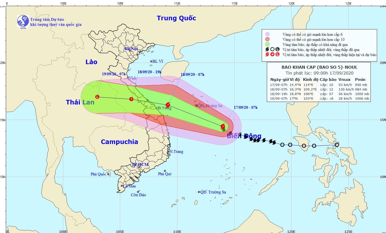
The 9am bulletin on September 17 of the National Center for Hydro-Meteorological Forecasting said that at 7am on September 17, the center of the storm was at about 14.4 degrees North latitude; 114.0 degrees East longitude, about 340km southeast of Hoang Sa archipelago. The strongest wind near the center of the storm was level 10 (90-100km/hour).level 12.
 |
| Expected path of Storm No. 5. Photo: kttv.gov.vn |
It is forecasted that in the next 24 hours, the storm will move in the West Northwest direction, traveling about 20km per hour and is likely to strengthen. At 7:00 a.m. on September 18, the center of the storm will be at about 16.3 degrees North latitude; 109.2 degrees East longitude, right on the sea of provinces from Quang Binh to Quang Ngai. The strongest wind near the center of the storm is level 11-12 (100-135km/hour).level 14.
Dangerous areas in the East Sea in the next 24 hours (strong winds from level 6, gusts from level 8 or higher): From latitude 11.5 degrees North to latitude 18.0 degrees North; west of longitude 116.5 degrees East. All ships operating in the dangerous area are at high risk of being affected by strong winds and whirlwinds.
Due to the influence of the storm, the area between the East Sea and the sea south of Hoang Sa archipelago has strong storm winds of level 8-10, then increasing to level 11-12., level 14. Rough seas. Disaster risk level: Level 3
In the next 24 to 36 hours, the storm will move in the West-Northwest direction, about 25km per hour, making landfall in the provinces from Quang Binh to Quang Nam with the strongest wind speed of level 10-11 (90-115km/hour).level 13and gradually weakened into a tropical depression. At 7:00 p.m. on September 18, the center of the tropical depression was at about 16.8 degrees North latitude; 106.0 degrees East longitude, in the Central Laos area. The strongest wind near the center of the tropical depression was level 7 (50-60 km/h).level 9.
Coastal areas of provinces from Ha Tinh to Thua Thien Hue need to be on guard against waves 3-5m high combined with storm surges 0.5-1.0m high causing flooding in lagoon areas, low-lying river mouths, and coastal areas.
In the next 36 to 48 hours, the tropical depression will move westward at about 25km per hour, weakening into a low pressure area over Thailand. Disaster risk level: Level 3, especially in coastal waters from Quang Binh to Quang Nam at level 4.
Heavy rain warning:
Due to the impact of storm No. 5, from the afternoon of September 17 to the night of September 18, the provinces from Ha Tinh to Quang Ngai will have heavy to very heavy rain with average rainfall of 200-300mm/period, in some places over 400mm; the provinces of the South Central Coast and the North Central Highlands will have moderate to heavy rain with average rainfall of 50-100mm/period. From September 18 to 20, the provinces of the Northern Delta, Thanh Hoa, and Nghe An will have moderate to heavy rain with average rainfall of 100-150mm/period.
In addition, due to the influence of the strong southwest monsoon, from September 17-19, the sea area from Binh Thuan to Ca Mau and the South East Sea area (including the sea area of Truong Sa archipelago) will have strong southwest winds of level 6-7, gusting to level 9. Waves will be 2-3.0m high. The sea will be rough.