
Typhoon No. 5 intensifies, heading towards Cao Bang and Lang Son.
Typhoon No. 5 is still moving in a direction between West and West-Northwest, currently gusting at level 13 in the East Sea. It is forecast that in the next 24-48 hours, the typhoon's center will pass through the border areas of Cao Bang and Lang Son provinces.
According to the National Center for Hydro-Meteorological Forecasting, at 4:00 AM on August 16th, the typhoon's center was located at approximately 19.1 degrees North latitude and 117.9 degrees East longitude, about 670km east-northeast of the Hoang Sa (Paracel) Islands. The strongest winds near the center of the typhoon were at level 10 or 11 (89 to 117 km per hour), with gusts reaching level 12 or 13.
The forecast for the next 24 hours indicates the storm will move in a direction between West and West-Northwest, traveling at approximately 20-25 km per hour, and is likely to intensify further. By 04:00 on August 17th, the storm's center will be located at approximately 20.9 degrees North latitude; 112.5 degrees East longitude, about 500 km East-Southeast of Mong Cai (Quang Ninh). The strongest winds near the storm's center will reach level 12 (118 to 133 km per hour), with gusts of level 13 and 14.
Over the next 24 to 48 hours, the storm will move in a direction between west and west-northwest at a speed of approximately 20-25 km per hour, along the southern coast of Guangxi Province (China).
As of 04:00 on August 18th, the typhoon's center was located at approximately 22.1 degrees North latitude and 107.0 degrees East longitude, on the border between Cao Bang and Lang Son provinces. The strongest winds near the center of the typhoon were at level 8 (62 to 74 km per hour), with gusts reaching levels 9 and 10.
Due to the influence of the storm, the northern part of the East Sea will experience strong winds of force 8-9, later increasing to force 10-11, reaching force 12 near the storm's center, with gusts of force 13-14. The sea will be extremely rough. In the northern part of the Gulf of Tonkin, from noon and afternoon tomorrow (August 17th), winds will gradually strengthen to force 6-7, reaching force 8-9 near the storm's center, with gusts of force 10-11. In the northern provinces, moderate to heavy rain, and even very heavy rain, is expected from afternoon and night tomorrow.
Additionally, due to the combined influence of the strong southwest monsoon, the central and southern areas of the South China Sea (including the waters around the Spratly Islands), and the sea area from Binh Thuan to Ca Mau will experience strong winds of force 6, gusting to force 7 and 8. The sea will be rough.
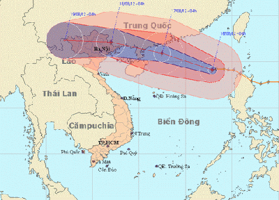
Image showing the predicted path of Typhoon No. 5.
Weather forecast for various regions today and tonight (August 16):
Northwestern region:Cloudy with scattered showers and thunderstorms in some areas. Light wind. Minimum temperature 23-26°C. Maximum temperature 31-34°C.
Northeastern Vietnam:Cloudy with sunny periods during the day, scattered showers and thunderstorms in the evening and at night. Light winds. Lowest temperature 25-28°C. Highest temperature 32-35°C.
Thanh Hoa - Thua Thien Hue:Cloudy with sunny periods, hot in the south, scattered showers and thunderstorms in the evening and at night. Southwesterly winds at force 2-3. Lowest temperature 25-28°C. Highest temperature 33-36°C.
Da Nang to Binh Thuan:Cloudy with sunny periods during the day, hot in the north, scattered showers and thunderstorms in the late afternoon and evening, no rain at night. Southwesterly winds at force 2-3. Lowest temperature 26-29°C. Highest temperature 34-37°C.
Central Highlands:Cloudy, with showers and thunderstorms in some areas during the afternoon and night. Southwesterly winds at force 2-3. Lowest temperature 21-24°C. Highest temperature 28-31°C.
Southern Vietnam:Cloudy with scattered showers and thunderstorms in the afternoon and evening. Southwesterly winds at force 2-3. Lowest temperature 24-27°C. Highest temperature 31-34°C.
Hanoi:Cloudy with sunny periods during the day; scattered showers and thunderstorms in the evening and at night. Light winds. Minimum temperature 26-29°C. Maximum temperature 32-35°C.
According to (vnmedia.vn)-LT


