Storm No. 8 heads towards Nghe An and Ha Tinh
It is forecasted that in the next 24 hours, storm No. 8 will move quickly towards the West towards the mainland, including Nghe An and Ha Tinh, at a speed of 25-30km per hour, entering the sea area south of the Gulf of Tonkin and is likely to gradually weaken in intensity.
According to the National Center for Hydro-Meteorological Forecasting, at 4:00 a.m. on October 13, the center of the stormstorm number 8at about 18.9 degrees North latitude; 113.9 degrees East longitude, about 270km Northeast of Hoang Sa archipelago. The strongest wind near the storm center is level 11 (100-120km/h), gusting to level 14. The radius of strong winds from level 6, gusting to level 8 or higher is about 350km from the storm center.
It is forecasted that in the next 24 hours, the storm will move quickly to the West, at 25-30km per hour, enter the sea area south of Bac Bo Gulf and may gradually weaken in intensity.
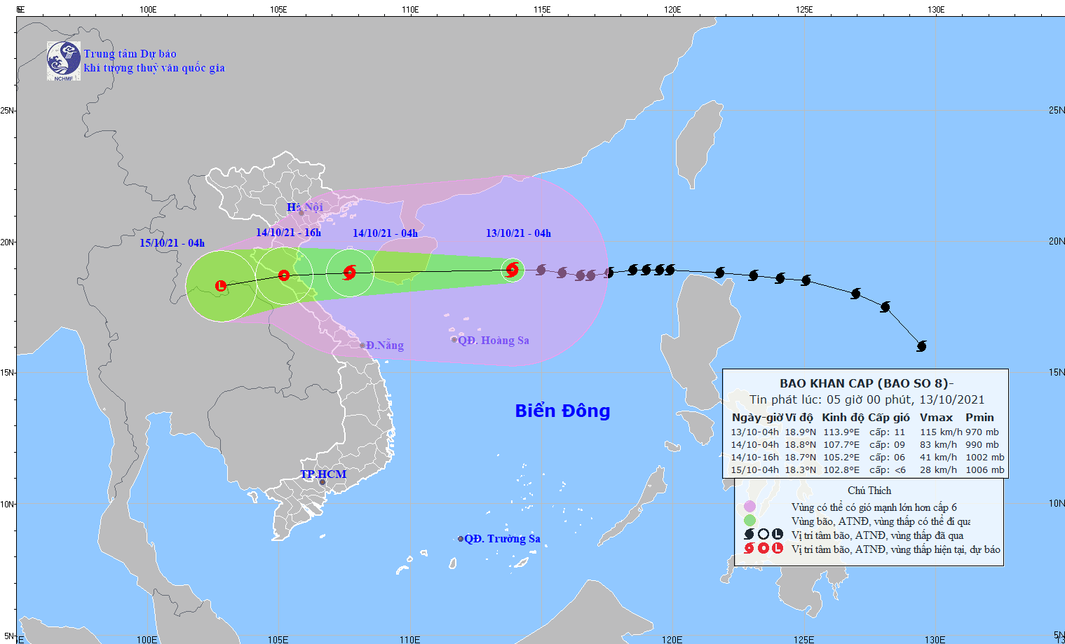 |
| Forecast of location and direction of storm No. 8 - Source: National Center for Hydro-Meteorological Forecasting. |
At 4:00 a.m. on October 14, the center of the storm was at approximately 18.8 degrees North latitude; 107.7 degrees East longitude. The strongest wind near the center of the storm was level 9 (75-90 km/h), gusting to level 11.
In the next 24 to 36 hours, the storm will move mainly in a westerly direction, about 20km per hour, go deep inland from Thanh Hoa to Quang Binh and weaken into a tropical depression.
At 4:00 p.m. on October 14, the center of the tropical depression was at about 18.7 degrees North latitude; 105.2 degrees East longitude. The strongest wind near the center of the tropical depression was level 6 (40-50 km/h), gusting to level 8.
In the next 36 to 48 hours, the tropical depression will move mainly westward, at about 20km per hour, and weaken into a low pressure area over Central Laos. At 4:00 a.m. on October 15, the center of the low pressure area was at about 18.3 degrees North latitude; 102.8 degrees East longitude. The strongest wind in the center of the low pressure area decreased to below level 6 (below 40km/h).
Dangerous areas in the East Sea in the next 24-48 hours (strong winds from level 6 and above, gusts from level 8 and above): North of latitude 15.5 degrees North; West of longitude 111.0 degrees East. All vessels operating in the dangerous area are at high risk of being affected by strong winds, big waves and whirlwinds. Warning level of natural disaster risk due to storm: level 3.
