Storm No. 9, with level 10 gusts, is 450km from the mainland and is likely to strengthen further.
(Baonghean.vn) - According to the National Center for Hydro-Meteorological Forecasting, in the next 24 to 48 hours, the storm will move mainly in a westerly direction, about 10-15km per hour, making landfall in the coastal provinces of the South Central and Southeast regions.
4:00 a.m. on November 23, the storm center is located at about 10.9 degrees North latitude; 113.0 degrees East longitude, in the northwest area of Truong Sa archipelago, about 450km east of the mainland of provinces from Ninh Thuan to Ba Ria-Vung Tau.
The strongest wind near the storm center is level 8 (60-75km/hour).jerky 10.Radius of strong winds level 6, gusting to level 8 about 100km from the center of the storm.
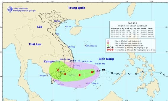 |
| Storm path and location. Photo: National Center for Hydro-Meteorological Forecasting |
Forecast for the next 24 hours,The storm is moving west-southwest at about 10-15km per hour and is likely to strengthen.At 4:00 a.m. on November 24, the storm's eye was at about 10.3 degrees North latitude; 110.5 degrees East longitude, about 230km east of the coast of provinces from Ninh Thuan to Ba Ria-Vung Tau, and about 130km east southeast of Phu Quy island.
The strongest wind near the storm center is level 9-10 (75-100km/hour).level 12.Radius of strong winds level 6, gusting to level 8 about 180km from the center of the storm.
Due to the influence of the storm, in the western area of the central and southern East Sea (including the sea area of Truong Sa archipelago), there will be stormy rain, strong winds of level 6-7, near the eye of the storm level 8, then increasing to level 9-10, gusting to level 12; very rough seas.
Dangerous areas in the East Sea in the next 24 hours: (strong wind level 6 or higher) from latitude 9.0 to 13.0 degrees North; west of longitude 115.0 degrees East.
Over the next 24 to 48 hours,The storm moves mainly in a westerly direction, about 10-15km per hour, making landfall in the coastal provinces of South Central andSoutheast regionwith strong intensity of level 8, then weakened into a tropical depression.
At 4:00 a.m. on November 25, the center of the tropical depression was at about 10.5 degrees North latitude; 107.6 degrees East longitude, on the mainland of the South Central and Southeast provinces. The strongest wind near the center of the tropical depression was level 7 (50-60 km/h).level 9.
Over the next 48 to 60 hours,The tropical depression moved in a West Northwest direction, about 10km per hour, went deep inland and gradually weakened into a low pressure area.
As of 4 p.m. on November 25, the center of the low pressure area was at about 11.3 degrees North latitude; 106.2 degrees East longitude, right on the mainland of the Southeast provinces. The strongest wind in the center of the low pressure area decreased to below level 6 (below 40km/h).Disaster risk level: level 3.
High Wind Warning:Due to the influence of cold air combined with the western edge of storm No. 9's circulation, from noon today in the sea areas of provinces from Quang Tri to Binh Thuan, winds will gradually increase to level 6, gusting to level 8;
From tomorrow morning (November 24), strong winds will be level 8, near the eye of the storm will be level 9-10, gusting to level 12. The sea will be very rough. Waves near the eye of the storm will be 5-7m high, near the shore will be 3-5m high.
Heavy rain warning: Due to the influence of storm No. 9 combined with cold air, from this evening and tonight (November 23) to November 26, in the provinces from Thua Thien Hue to Binh Thuan and the Southern Central Highlands, there will be very heavy rain (300-500mm/period); the Northern Central Highlands and the South will have heavy rain (100-200mm/period).
Flood warning:From November 24-27, a flood will occur on rivers from Quang Tri to Binh Thuan and the Central Highlands. The flood peak on rivers from Quang Tri to Quang Nam and the Central Highlands is likely to be at level 1-2 and above level 2; rivers from Quang Ngai to Binh Thuan will be at level 2-3 and above level 3. There is a high risk of flash floods, landslides in mountainous areas, and flooding in low-lying and urban areas in the above provinces.Disaster risk level: level 1-2.
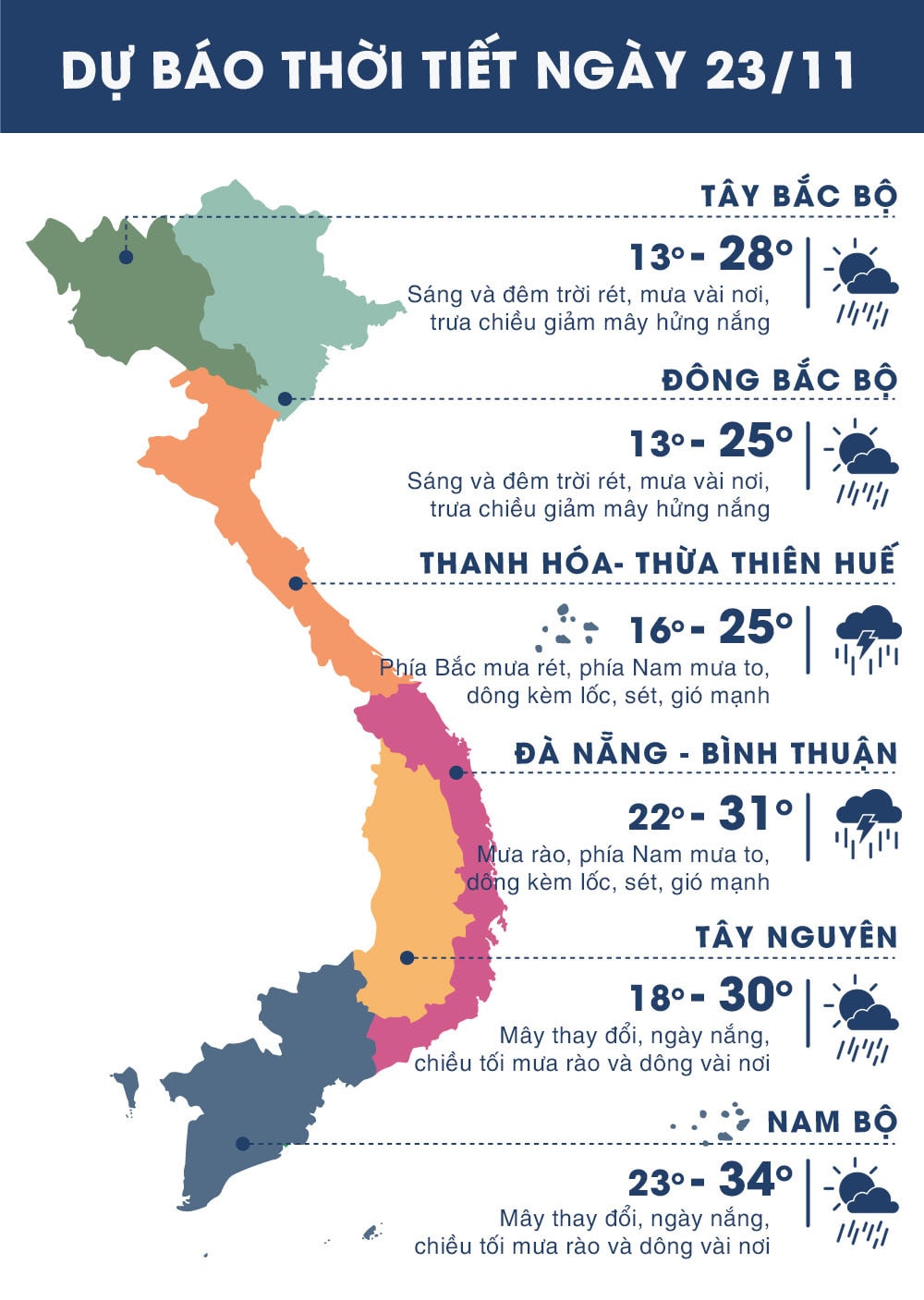 |
| Temperature on November 23 in regions across the country. Photo: news.zing.vn |