
Typhoon Wipha reached level 15 in the northern part of the South China Sea.
According to the National Center for Meteorological and Hydrological Forecasting, at 13:00 on July 20th, the center of Typhoon Wipha was located at approximately 21.9°N; 113.4°E, in the northern part of the North East Sea, about 630km east of Quang Ninh-Hai Phong.
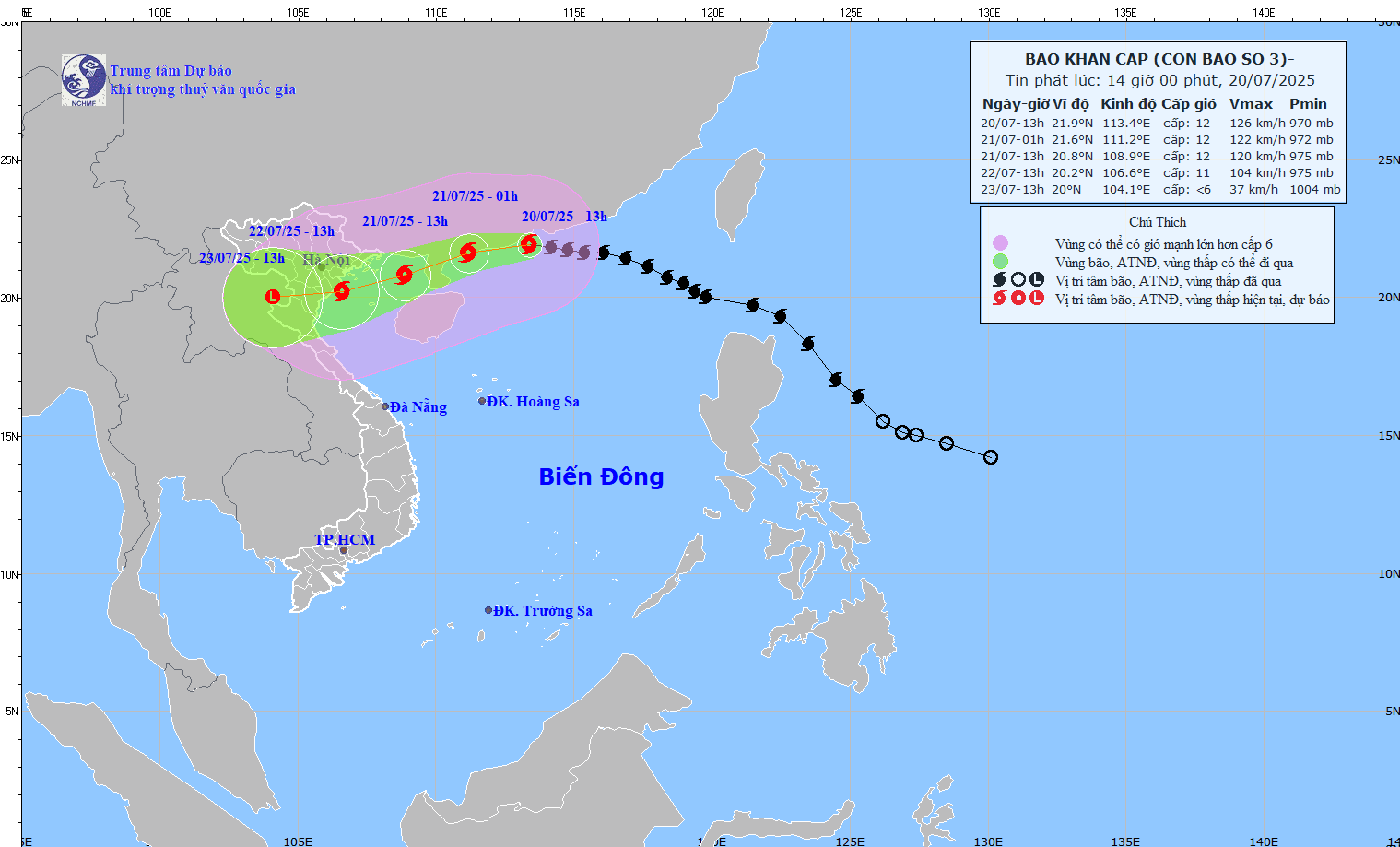
At 13:00 on July 20th, the typhoon's center was located at approximately 21.9°N; 113.4°E, in the northern part of the South China Sea, about 630km east of Quang Ninh-Hai Phong. The strongest winds near the center of the typhoon reached level 12 (118–133 km/h), with gusts up to level 15. The typhoon was moving westward at a speed of 20–25 km/h.
Forecast:
As of 13:00 on July 21st: The storm was located at approximately 20.8°N; 108.9°E, over the sea east of the northern part of the Gulf of Tonkin. Its intensity was level 11-12, with gusts up to level 15.
As of 13:00 on July 22nd: The storm was located at approximately 20.2°N; 106.6°E, over the coastal area of Quang Ninh – Thanh Hoa. Its intensity was level 10–11, with gusts up to level 14.
By 1 PM on July 23rd: Over the Upper Laos region, the area gradually weakened into a low-pressure zone.
Strong winds – rough seas
Northern sea area of the North East Sea: Strong winds of force 8–10, near the storm center force 11–12, gusts up to force 15. Waves 5.0–7.0m high, extremely rough seas.
Northern Gulf of Tonkin (Bach Long Vi, Co To, Cat Hai, Hon Dau): Strong winds of force 6-7, increasing to force 8-9, near the storm center force 10-11, gusts up to force 14. Waves 3.0-5.0m high.
Southern Gulf of Tonkin (Hon Ngu Island): Strong winds of force 6–7, near the storm's center force 8–9, gusts up to force 11. Waves 2.0–4.0m high.
Recommendation:Vessels operating in the hazardous zone are at high risk of encountering thunderstorms, tornadoes, strong winds, and high waves. The coastal areas of Hai Phong and Quang Ninh are at risk of flooding due to storm surge of 0.5–1.0m, with a total water level of 4.0–5.0m by noon and afternoon of July 22nd.
From the evening and night of July 21st, coastal areas from Quang Ninh to Nghe An will experience strong winds of force 7-9, near the storm's center force 10-11, gusting to force 14. Inland areas will have winds of force 6-7, gusting to force 8-9.
From July 21-23, the Northeast region, the Northern Delta, Thanh Hoa, and Nghe An will experience heavy to very heavy rain (200-350mm, with some areas exceeding 600mm). Northern Vietnam and Ha Tinh will have moderate to heavy rain (100-200mm, with some areas exceeding 300mm). A warning is issued regarding the risk of heavy rainfall exceeding 150mm/3h.


