Warning of heavy rain, flash floods, and landslides inland.
(Baonghean.vn) - According to the Central Meteorological and Hydrological Forecasting Center, the tropical depression is moving inland. From this morning (September 24), there will be rain in the northeastern and north-central provinces; in the afternoon and evening, there will be moderate to heavy rain, with very heavy rain in some places.
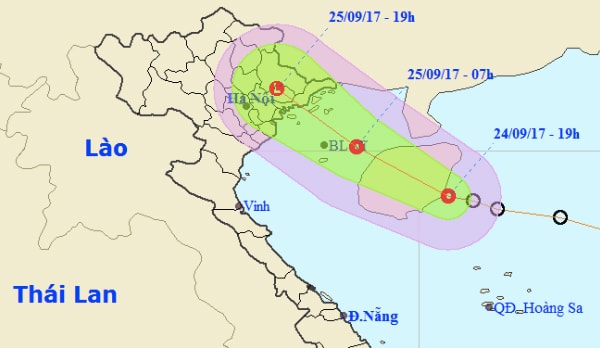 |
| This afternoon, the low-pressure system moved inland, bringing moderate to heavy rain across the Northeast and North Central regions of Vietnam. |
At 4:00 AM on September 25thThe center of the tropical depression is located at approximately 19.9 degrees North latitude and 108.8 degrees East longitude, about 220km east-southeast of the Quang Ninh-Hai Phong coast. The strongest winds near the center of the tropical depression are at level 6-7 (40-60km/h), with gusts up to level 9.
Forecast for the next 12 hours,The tropical depression is moving west-northwest at a speed of 20-25 km/h; it will make landfall in Quang Ninh and Hai Phong provinces around this afternoon (September 25th) with wind speeds of level 6, gusting to level 8. By 4 PM on September 25th, the center of the tropical depression will be located at approximately 21.2 degrees North latitude; 107.0 degrees East longitude, over land in the Quang Ninh-Hai Phong area. The strongest winds near the center of the tropical depression will be level 6 (40-50 km/h), gusting to level 8.
Forecast for the next 12 to 24 hours,The tropical depression moved in a west-northwest direction, weakened into a low-pressure area, and gradually dissipated over the northern mountainous region.
Warning of strong winds and high waves at sea:In the northern Gulf of Tonkin (including the island districts of Bach Long Vy, Co To, Cat Hai, and Van Don), winds will gradually strengthen to level 6, increasing to level 7 in the afternoon, with gusts up to level 9; sea waves will be 2-3 meters high; the sea will be rough. Disaster risk level: level 3.
Strong wind warning on land:From this afternoon, strong winds, reaching level 6 with gusts up to level 8, will gradually increase in the inland areas of Quang Ninh and Hai Phong provinces. The level of natural disaster risk is level 3.
Heavy rain warning:From this morning, rain has fallen in the northeastern and north-central provinces; moderate to heavy rain, and very heavy rain in some areas, is expected in the afternoon and evening. The total rainfall from 7:00 AM on September 25th to 1:00 PM on September 26th is expected to be 50-100mm, with some areas in the Northeast receiving over 150mm. This evening and tonight, rain is expected in the northwestern provinces, with moderate to heavy rain in some areas.
Flood, flash flood, and landslide warnings:On the upper reaches of the Lo and Thai Binh rivers, a small flood with a water level increase of 1-2m is likely to occur (flood peaks on all rivers will be below alarm level 1). There is a risk of landslides and flash floods in the provinces of Quang Ninh, Lang Son, Cao Bang, Bac Can, Thai Nguyen, and Tuyen Quang. Natural disaster risk level warning: Level 1.
Due to the influence of the southwest monsoon, the sea areas of Binh Thuan-Ca Mau, Ca Mau-Kien Giang, and the Gulf of Thailand will experience heavy rain and thunderstorms. During thunderstorms, there is a possibility of tornadoes and gusts of wind reaching levels 7-8.
Weather forecastfromThanh Hoa - Binh ThuanSeptember 23rd:
Thanh Hoa - Thua Thien Hue:Cloudy, with showers and scattered thunderstorms; in the North, moderate to heavy rain in the afternoon and evening, with very heavy rain in some areas. West to southwest winds, 2-3 Beaufort scale. Tornadoes, waterspouts, and strong gusts of wind are possible during thunderstorms. Humidity: 65-97%. Temperature: 24-31°C.oC.
Da Nang to Binh Thuan:Cloudy with scattered showers and thunderstorms in some areas. Southwesterly winds, force 2-3. Humidity 60-95%. Temperature 25-34°C.oC.
Hoa Le
(Synthetic)
| RELATED NEWS |
|---|

