Update the latest information of storm number 1; Central region still has cold rain
(Baonghean.vn) - According to the National Center for Hydro-Meteorological Forecasting, today (January 4), the Central region continues to have cold rain, with the lowest temperature ranging from 13 to 16 degrees Celsius.
 |
| Illustration photo. |
Yesterday day and night (January 3),In the provinces from Ha Tinh to Binh Thuan and the Southwest region, there has been rain, moderate rain, and in some places heavy rain to very heavy rain such as (rainfall as of 1:00 a.m. on January 4): Nui Thanh (Quang Nam) 35.6mm, Hoa Binh (Bac Lieu) 144.0mm, Ben Tre 84.6mm, Phu Tan (An Giang) 57.8mm, Ngoc Hien (Ca Mau) 56.4mm, Long Phu (Soc Trang) 49.0mm...
Forecast:Due to the influence of the high altitude East wind zone, this morning (January 4), in the provinces from Thua Thien Hue to Binh Thuan, there will be rain, moderate rain, heavy rain in some places with common rainfall of 10-20mm, in some places over 30mm.
This morning (January 4), due to the influence of the northeastern edge of storm No. 01, in the Southwest region there will be moderate to heavy rain with common rainfall of 20-40mm, in Ca Mau in some places it will be greater than 50mm; from this afternoon the rain will gradually decrease.
Warning:This morning in the South there is a possibility of thunderstorms, tornadoes, and strong gusts of wind.Disaster risk level: level 1
Thanh Hoa - Thua Thien Hue:Cloudy, some rain in the North; scattered rain in the South (from Ha Tinh to Thua Thien Hue). North to northwest wind level 2-3. Cold. Humidity from 65 - 98%
Lowest temperature from:13 - 16oC
The highest temperature from:17 - 20 degrees, some places above 20oC
Da Nang to Binh Thuan:Cloudy, morning rain, moderate rain, some places heavy rain and thunderstorms; later scattered showers and thunderstorms. Northeast wind level 2-3. In the North, the morning and night are cold. During thunderstorms, there is a possibility of tornadoes, lightning and strong gusts of wind. Humidity from 65 - 98%
Lowest temperature from:18 - 21 degrees, South 21 - 24oC
Highest temperature from:23 - 26 degrees, South 27 - 30oC
Update information on storms near shore
At 4:00 a.m. on January 4, the storm center is located at about 7.0 degrees North latitude; 102.9 degrees East longitude, about 260km southwest of Ca Mau cape. The strongest wind near the storm center is level 9 (75-90km/hour),level 12.Radius of strong winds level 6, gusting to level 8 about 130km from the center of the storm.
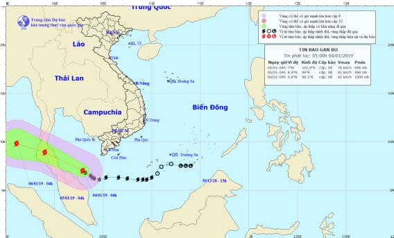 |
| Storm path and location. Photo: National Center for Hydro-Meteorological Forecasting |
Forecast for the next 24 hours,The storm is moving in the West Northwest direction, traveling 15-20km per hour. At 4:00 a.m. on January 5, the center of the storm was at about 8.9 degrees North latitude; 99.0 degrees East longitude,wayTho Chu Island (Kien Giang) about 500km to the West Southwest. The strongest wind near the storm center is level 8-9 (60-90km/hour).level 11Radius of strong winds level 6, gusts level 8 about 120km from the center of the storm.
Dangerous areas affected by storms in the East Sea in the next 24 hours(strong wind level 6, gust level 8 or higher): North of latitude 5.0 degrees North; West of longitude 105.0 degrees East.
Over the next 24 to 48 hours,The storm is moving west-northwest at 15-20km per hour.
Due to the influence of storm No. 1, the Southern Gulf of Thailand and the sea area south of Ca Mau have strong winds of level 6-7, the area near the storm's eye has winds of level 8-9.level 11, waves from 2-5m high, very rough sea. The sea area of provinces from Ca Mau to Kien Giang (including Phu Quoc island district and Tho Chu island) has windlevel 6-7, waves 2-3m high, rough sea.Disaster risk level: level 3.
