Update the latest information about storm number 1
(Baonghean.vn) - At 1:00 p.m. on January 2, the center of the storm was located at about 6.1 degrees North latitude; 108.2 degrees East longitude, about 430km southeast of the mainland of the Southern provinces, about 340km southeast of Con Dao. The strongest wind near the center of the storm was level 8 (60-75km/h), gusting to level 10.
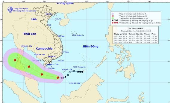 |
| Path and location of storm No. 1. Photo: National Center for Hydro-Meteorological Forecasting |
Forecast for the next 24 hours,The storm is moving in a West-Northwest direction, traveling about 15km per hour. At 13:00 on January 3, the center of the storm was at 6.9 degrees North latitude; 104.4 degrees East longitude, about 200km south of Ca Mau Cape, about 300km southwest of Con Dao. The strongest wind near the center of the storm is level 8 (60-75km/hour),level 10.
Dangerous areas in the East Sea in the next 24 hours(strong wind level 6, gust level 8 or higher): North of latitude 5.0 degrees North.
Over the next 24 to 48 hours,The storm is moving in a West-Northwest direction, traveling about 15km per hour and is likely to strengthen. At 1pm on January 4, the center of the storm was at about 8.7 degrees North latitude; 101.3 degrees East longitude, about 350km west of Ca Mau Cape, about 230km west-southwest of Tho Chu Island (Kien Giang). The strongest wind near the center of the storm is level 8-9 (60-90km/hour),level 11.
During the next 48 to 72 hours,The storm is moving mainly in the West Northwest direction, traveling about 15km per hour. At 13:00 on January 5, the center of the storm was at about 10.3 degrees North latitude; 98.0 degrees East longitude. The strongest wind near the center of the storm is level 9 (75-90km/hour),level 11.
From today (January 2) to the end of January 3, in the western sea of the South China Sea, the sea south of Ca Mau will have strong winds of level 7, the area near the storm's eye will have winds of level 8.level 10, rough seas; offshore waters from Quang Ngai to Binh Thuan provinces (including Phu Quy island district) have strong winds of level 6-7,level 9,rough seas; offshore waters from Ba Ria-Vung Tau to Ca Mau provinces (including Con Dao island district) have strong winds of level 6,level 7-8, rough seas.
In addition, due to the influence of cold air, in the North and Central East Sea (including the waters of Hoang Sa archipelago), there will continue to be strong Northeast winds of level 6-7.level 8; rough seas.Disaster risk level: level 3.
NEWS OF WIDE-RANGE HEAVY RAIN IN THE CENTRAL AND SOUTHERN REGIONS
Last night and today (January 1),In the provinces from Ha Tinh to Binh Thuan, there will continue to be moderate rain, with some places experiencing heavy to very heavy rain such as (rainfall as of 1:00 p.m. on January 2): Tay Hoa (Phu Yen) 118mm, Van Ninh (Khanh Hoa) 66mm, Quy Nhon (Binh Dinh) 33mm,...
Forecast:Due to the influence of cold air combined with disturbances in the high-altitude East wind zone, from now until January 4, in the provinces from Thua Thien Hue to Binh Thuan, there will be moderate rain, heavy rain, and in some places very heavy rain with common rainfall of 50-100mm/24 hours, especially in the provinces of Quang Nam, Quang Ngai, Binh Dinh, Phu Yen, some places will have over 150mm/24 hours.
From today (January 2) to January 4, due to the influence of the northern edge of storm No. 01, in the Southeast region there will be rain, moderate rain, and heavy rain in some places (40-80mm/period); in the Southwest region there will be moderate rain, heavy rain (70-150mm/period), especially in the provinces of Soc Trang, Bac Lieu, Ca Mau, and Kien Giang, there will be very heavy rain in some places (150-200mm/period).
Warning:From today (January 2) to January 4, there is a high possibility of thunderstorms, tornadoes, and strong gusts of wind in the South.Disaster risk level: level 1