Update the latest information on cold air and tropical depression
(Baonghean.vn) - The National Center for Hydro-Meteorological Forecasting predicts that due to the influence of cold air, there will be heavy rain and thunderstorms in the North and Central regions today. During thunderstorms, there is a possibility of tornadoes, lightning, hail and strong gusts of wind.
Early this morning (November 22):Cold air has affected the northeastern provinces, some places in the western part of the North and the North Central region, causing scattered showers and thunderstorms. In the Gulf of Tonkin, there are strong northeast winds of level 7, gusting to level 8.
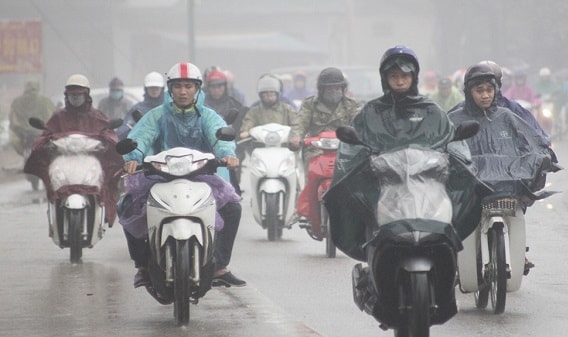 |
| Forecast for heavy rain and thunderstorms in Central Central region today. Illustrative photo |
Forecast:Today and tonight (November 22), cold air continues to affect other places in the Northwest, North Central and then some places in the Central Central. Northeast wind inland level 3, coastal areas level 3-4. In the Northern provinces, the weather turns cold with the lowest temperature commonly 16-19 degrees, mountainous areas 13-15 degrees.
Due to the influence of cold air, in the North this morning there will be rain, some places will have moderate rain, heavy rain and thunderstorms, then there will be rain in some places; in the North and Central Central provinces there will be rain, moderate rain, some places will have heavy rain and thunderstorms; in the thunderstorm there is a possibility of tornadoes, lightning, hail and strong gusts of wind.
In the Gulf of Tonkin, there are strong northeast winds of level 6-7, gusting to level 9; in the North East Sea, the northeast winds gradually increase to level 7, gusting to level 9; the sea is rough.
Latest information on tropical depression in the East Sea
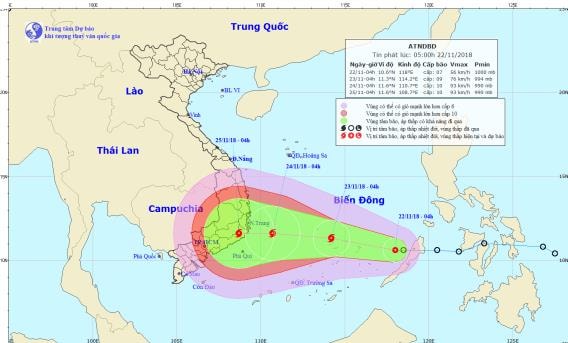 |
| Location and path of the tropical depression. Photo: National Center for Hydro-Meteorological Forecasting |
04:00, the center of the tropical depression is located at about 10.6 degrees North latitude; 118.0 degrees East longitude, about 400km East Southeast of Song Tu Tay Island (in Truong Sa archipelago). The strongest wind near the center of the tropical depression is level 7 (50-60km/hour),jerk 9. Radius of strong winds level 6, gusting to level 8 about 80km from the center of the tropical depression.
Forecast for the next 24 hours,The tropical depression is moving west-northwest at 15-20km per hour and is likely to strengthen into a storm. At 4:00 a.m. on November 23, the center of the storm was at about 11.3 degrees north latitude; 114.2 degrees east longitude, right on Song Tu Tay Island (in Truong Sa archipelago).
The strongest wind near the storm center is level 8-9 (60-90km/hour).level 12. Radius of strong winds level 6, gusting to level 8 about 150km from the center of the storm.
Due to the influence of the tropical depression, there is rain in the Southeast of the East Sea. From early this morning, the wind is strong at level 6-7, then increasing to level 8-9, gusting to level 11; the sea is very rough.Disaster risk level: level 3.
Dangerous areas in the East Sea in the next 24 hours: (strong wind level 6 or higher) from latitude 9.5 to 13.0 degrees North; east of longitude 112.5 degrees East.
Over the next 24 to 48 hours,The storm is moving west at about 15km per hour and is likely to strengthen. At 4am on November 24, the center of the storm was at about 11.6 degrees North latitude; 110.7 degrees East longitude, about 190km east of the coast of the South Central provinces.
The strongest wind near the storm center is level 9-10 (75-100km/hour).level 12.Disaster risk level: level 3.
During the next 48 to 72 hours,The storm is moving west at 10km per hour. At 4am on November 25, the center of the storm was at approximately 11.6 degrees North latitude; 108.7 degrees East longitude, right on the mainland of the South Central provinces.
The strongest wind near the storm center is level 9-10 (75-100km/hour).level 12.Disaster risk level: level 3.