Urgent response to the risk of 'multi-disasters' caused by storm No. 10 Bualoi
Faced with the rapid and dangerous developments of storm No. 10 Bualoi, Nghe An Newspaper, Radio and Television reporters had a quick interview with Mr. Nguyen Xuan Tien - Director of Nghe An Hydrometeorological Station about forecasts and warnings of possible risks before, during and after storm Bualoi makes landfall.
Reporter: As of noon on September 27, can you tell us the location and level of activity of storm No. 10 Bualoi?
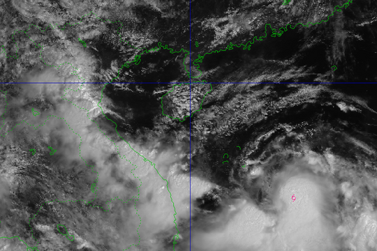
Mr. Nguyen Xuan Tien:As of 10:00 a.m. today, September 27, the center of the storm was at about 14.5 degrees North latitude; 114.9 degrees East longitude, about 370 km East Southeast of Hoang Sa special zone. The strongest wind near the center of the storm was level 11-12 (103-133 km/h), gusting to level 15. The storm was moving in a West Northwest direction at a speed of about 35 km/h.

This is a very fast moving storm (nearly twice the average speed), with strong storm intensity and wide range of influence, which can cause combined impacts of many types of natural disasters such as strong winds, heavy rains, floods, flash floods, landslides and coastal flooding.
Previously, in the past 24 hours, many areas in Nghe An had heavy to very heavy rain. In particular, the southwestern mountainous region had scattered rain and showers. The rainfall from 7am on September 26 to 7am on September 27 was generally 20-120mm, with higher rainfall in some places such as Nong Truong 1/5: 294mm, Hoang Mai 270mm, Hua Na Hydropower Plant 260mm. The southwestern mountainous region was generally below 15mm.
Reporter: How is the storm forecast to affect Nghe An in the coming time? Which localities need to pay special attention and improve prevention work?
Mr. Nguyen Xuan Tien:Forecast of heavy rain in the next 24 - 48 hours: From September 27 to the end of the night of September 28, localities in Nghe An will continue to have heavy to very heavy rain and thunderstorms. Forecasted rainfall: in coastal plains and midlands: 150 - 250mm, some places over 350mm such as: Hoang Mai, Truong Vinh, Nam Dan... Mountainous areas: 100 - 200mm, some places over 250mm such as: Que Phong, Quy Chau... Warning of risk of heavy rain (80mm/3h). In thunderstorms, there is a possibility of tornadoes, lightning, hail and strong gusts of wind.

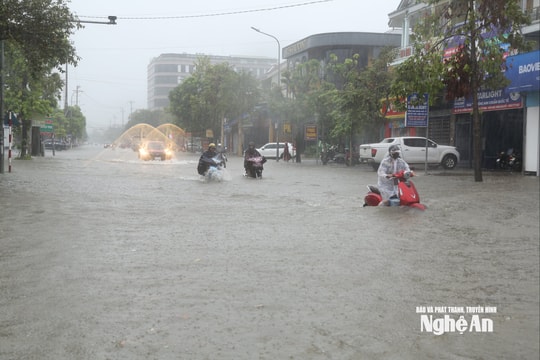
It is forecasted that during the day and night of September 29, communes and wards of Nghe An province will continue to have moderate to heavy rain with common rainfall of 30-60mm, some places over 100mm. Therefore, it is necessary to raise vigilance, prevent damage caused by heavy rain in a short time causing flooding in urban areas and low-lying areas. There is a risk of flash floods on small rivers and streams, landslides on steep slopes. During thunderstorms, there is a possibility of tornadoes, lightning, hail and strong gusts of wind.
In particular, during and after the storm, it is forecasted that there will be heavy rain and landslides, causing a "multi-disaster" phenomenon, which is a combination of many types of damage caused by natural disasters such as floods, landslides, flash floods, thunderstorms, lightning, etc.
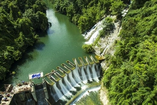
Currently, the reservoirs in the province are almost full, so if the rain continues, it will easily cause flooding in the downstream areas, riverside areas, low-lying areas, and urban areas. This is a storm with strong intensity and fast moving speed, directly affecting the sea, midland and mountainous areas when the storm makes landfall and circulates after the storm. Therefore, in the immediate future, coastal areas need to strengthen their response to high waves, strong winds and rising water, which pose a danger to the dyke system, houses, and boats.

Localities forecast to be heavily affected, at risk of flooding and flash floods: Quynh Luu, Nghia Dan, Tay Hieu, Hoang Mai, Yen Thanh, Dien Chau, Cua Lo, Nghi Loc, Truong Vinh, Hung Nguyen, Kim Lien, Son Lam, Do Luong, Quy Hop, Muong Xen, Con Cuong, Tan Ky, Anh Son, Tuong Duong, Quy Chau, Que Phong... These localities have had heavy rain, some places have had flooding and landslides causing traffic jams, isolating villages and hamlets.
Reporter: To promptly update weather forecasts and warnings, how does the Hydrometeorological Station deploy on-duty activities as well as contact and coordinate with relevant authorities and localities?
Mr. Nguyen Xuan Tien:When there are unusual weather developments, we always increase the number of shifts on duty 24/24h. These days, almost 100% of the staff of our Hydrometeorological Station increase the frequency of duty and maintain almost 100% of the staff to meet the task of regularly updating weather developments. Normally, weather forecasts and warnings are issued every 3 hours. But when there are unusual developments, especially forecasts and warnings of strong storms, we increase the forecast frequency, updating 1 bulletin every hour.
This forecast information will be sent to authorities and localities, posted on specialized information pages as well as promptly provided to news agencies and newspapers to convey to people and localities as quickly and promptly as possible.
.jpg)
Currently, we are maintaining 23 meteorological and hydrological stations in localities, along with the activities of the "command" agency to synthesize information, update promptly, and meet the requirements of weather forecasting work.
Reporter:Thank you for the conversation!


