
Proactive response to landslides during the rainy season.
(Baonghean) - With the rainy season approaching, many localities from mountainous areas to the plains are facing the risk of landslides, affecting the lives and property of thousands of households. To proactively respond to this situation, localities have proactively implemented both immediate and long-term solutions.
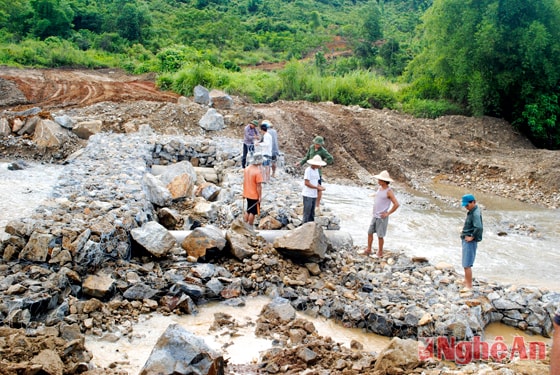 |
| Residents of Tri Le commune, Que Phong district, are building stone embankments to prevent erosion along the Nam Chot river. Photo: VT |
Efforts to integrate migration
Chau Thanh commune (Quy Hop district) has 987 households, of which over 50% live along streams, posing a constant threat to people's lives and property during the flood season. In Huong village, Chau Thanh commune, Ms. Vi Thi Mui, who is driving stakes along the stream to protect the land from erosion, said: "During the heavy rains at the beginning of 2014, the soil eroded into a deep ravine just 3 meters from my house. To ensure the safety of people's lives and property, the commune People's Committee built a stone embankment to prevent landslides for about a dozen households in this area."
Faced with this situation, the Emergency Resettlement Project for the Piêng Luống landslide area in Châu Thành commune was launched in 2009, with a total value of nearly 19 billion VND. According to the plan, in 2010, the project was supposed to resettle over 50 households in areas at risk of mountain and stream bank landslides. However, due to funding difficulties, items such as land leveling, electricity, water, and transportation infrastructure remain unfinished. To proactively respond, Mr. Hà Đăng Ninh, Vice Chairman of the Châu Thành Commune People's Committee, stated that in addition to encouraging residents to use bamboo stakes at landslide-prone areas around their homes, the commune has also allocated budget to reinforce some key landslide sections in Huống village. However, this is only a temporary solution.
It is known that Quy Hop district has 3 emergency relocation projects for disaster-prone areas according to Decision 1776 of the Prime Minister. These are: the emergency relocation project in Pieng Luong commune, Chau Thanh district, relocating 50 households; and the emergency relocation project in Chau Tien and Lien Hop communes, relocating 73 households. The total investment for the 3 projects is over 54 billion VND. However, due to funding difficulties, after 3-4 years of implementation, most items have not been completed. All 123 households benefiting from the relocation policy to resettlement areas in Quy Hop are living in temporary houses near riverbanks, streams, and areas at risk of landslides. Faced with this reality, Quy Hop district has proactively implemented solutions to ensure the safety of the people. Mr. Hoang Van Thai - Head of the Agriculture Department of Quy Hop district said: The district has over 200 households in areas at risk of riverbank and stream landslides. To cope with the rainy season and floods, the district directed communes to encourage residents to relocate to safe areas. For households in particularly dangerous areas, relocation was carried out using provincial support funds of 10 million VND per relocated household. From 2013 to the present, over 20 households in the entire district have been relocated to villages where they are currently living.
In Quy Chau district, the district has proactively organized the relocation of households living in areas at high risk of landslides, following the approval of the "Emergency Relocation Project for Disaster-Affected Areas in Chau Hoi Commune, Quy Chau District" by the Provincial People's Committee on March 20, 2013, with a total capital of 49 billion VND, which was expected to relocate over 70 households but has not yet been implemented. Discussing solutions to ensure the safety of people in landslide-prone areas, Mr. Vi The Long, Head of the Rural and Mountainous Development Board of Quy Chau district, said: Through a review, Quy Chau district has approximately 535 households in areas at risk of riverbank and mountain landslides in the communes of Chau Hoi, Chau Tien, Chau Thang, Chau Hanh, etc. To ensure the safety of the people, from 2009 to the present, the district has relocated 62 households using provincial support funds of 10 million VND per relocated household. The remaining households cannot be relocated due to the scarcity of flat land, while the budgets of the commune and district are limited.
Regarding solutions to accelerate the construction progress of resettlement projects and ensure the safety of the people, Mr. Tran Van Quy, Head of the Provincial Rural Development Sub-Department, said: The province currently has 22 emergency resettlement projects for disaster-stricken areas, but only 4 projects have been completed and put into use. The delay is due to a lack of funding. To date, only over 170 billion VND out of 755 billion VND has been disbursed. The Provincial People's Committee and the Rural Development Sub-Department have proposed to the Central Government to request additional funding. The province has also tried to mobilize various sources to integrate and support the implementation of the projects. Therefore, the proposed solution is to only resettle scattered households. From 2010 to the present, over 300 households have been resettled in scattered areas.
Responding to riverbank erosion
Every year, during the rainy season, people living near the riverbanks along the Lam River face the risk of landslides and loss of agricultural land, directly affecting their livelihoods. Standing on the riverbank in Hamlet 6, Ngoc Son Commune (Do Luong District), looking out at the Lam River with its rising, muddy water, Ms. Hoang Thi Hanh said: “Previously, the riverbank was wide, nearly 100 meters from the river, making farming very convenient. But for the past few years, landslides have occurred every year, sweeping away large areas of acacia, bamboo, and mulberry trees that people planted to protect their crops. From 2010 until now, my family has leased 2 sao (approximately 0.2 hectares) of riverbank land from the commune, with a lease term of 5 years at a time. For more than two years now, more than 1 sao of my mulberry and corn crops have been washed away by landslides. Currently, many other farmers in Ngoc Son Commune are facing the same situation.”
Boi Son commune (Do Luong district) has a riverside alluvial plain covering over 19 hectares. For nearly 10 years, the Boi Son Commune People's Committee has leased this area to dozens of households in Hamlet 8 at a rate of 16-19 million VND per year to cultivate perennial trees such as Melaleuca alternifolia, Melaleuca alternifolia, annual crops, and raise nearly 300 buffaloes and cows. However, now that the crops are entering their main harvest season, the households that leased the land are facing the risk of losing it due to continuous erosion. Mr. Le Khac Tam, from Hamlet 8, Boi Son commune, shared: “Nearly 2 hectares of the alluvial plain have been eroded. The erosion has swept away many Melaleuca alternifolia and corn plants. We proactively harvested and sold many young Melaleuca trees.” According to Mr. Le Van Bieu, Chairman of the Boi Son Commune People's Committee: Besides the alluvial plain, the latest survey results for the second land allocation show that the entire commune only has 8 out of 15 hectares of alluvial land remaining, concentrated in 6 out of 8 hamlets along the river.
Landslides in Anh Son are also a serious concern for residential land. Since 1992, Tan Lam hamlet (Cam Son commune) has been designated as residential land by the commune. The village covers over 3 hectares and is home to 37 households engaged in agricultural production, located approximately 30 meters from the Lam River bank. Every year, before the rainy season, the commune directs residents to plant bamboo and other trees to prevent soil erosion, protect crops and livelihoods, and relocate residents to the hamlet's cultural center. Mr. Nguyen Van Thang, Vice Chairman of the Cam Son Commune People's Committee, said: "The rising water levels of the Con and Lam rivers are causing continuous landslides, encroaching on the village's residential land. The commune has submitted a proposal to the district and province requesting funding for the construction of riverbank erosion control embankments to protect residents and production." Besides the two "hot spots" of Do Luong and Anh Son, landslides are widespread in many localities in the province such as Hung Nguyen, Thanh Chuong, Tan Ky, and Nam Dan. A series of serious landslides have occurred consecutively, causing not only land loss for residents but also significant disruption to their lives.
Regarding the causes of landslides, Mr. Hoang Nghia Hieu, Head of the Provincial Department of Dike Management and Flood Control, stated: “The riverside areas along the Lam River are often unstable due to the impact of the current, so landslides are a natural phenomenon. However, illegal sand and gravel mining on the river is a direct factor, causing a series of landslides and erosion along the riverbanks and floodplains, affecting the safety of embankments and leading to the loss of agricultural land in many localities. In our province, nearly 30 riverbank erosion control embankments have been built, mainly in key landslide-prone areas such as near residential areas, roads, and dikes where people live. However, due to the high investment costs for embankment construction, many people in landslide-prone areas are currently having to accept living with the natural disaster.”
Faced with this situation, to mitigate the risk of landslides, especially during the rainy season when river levels rise and the currents are strong and swift, localities have proactively implemented solutions to minimize landslides and damage to the people. In Do Luong district, in addition to calculating the value of agricultural production on land affected by landslides to deduct from the annual land allocation for residents, the district also focuses on regulating sand and gravel mining activities on the river. Furthermore, based on funding from the Department of Agriculture and Rural Development, Do Luong district has completed the resettlement of 68 households living on the Lam River floodplain in Hamlet 5, Dang Son commune, with each household receiving 160m2 of land.
In Anh Son district, since the beginning of 2014, the People's Committee of Anh Son district has issued Directive 11/2014/CT-UBND on "Strengthening State management of mineral exploitation activities in Anh Son district," specifying the responsibilities of the chairmen of the People's Committees of communes, the district police, and heads of relevant departments and agencies to publicly monitor sand and gravel mining activities on the river, and to strengthen coordination in handling violations with relevant levels and sectors. The project to build an embankment to prevent erosion along the Lam River section passing through Dinh Son commune and the town is currently receiving attention from the province for construction.
According to Mr. Hoang Nghia Hieu, in the long term, the solution to the risk of landslides and loss of agricultural land is to effectively protect existing forests, plant new forests in upstream areas to limit local runoff, and operate floodgates according to proper procedures. In particular, sand and gravel mining needs to be planned to contribute to economic development, generate revenue for the State, and reduce the risk of landslides. The province needs to quickly plan the areas for licensed sand and gravel mining, establish strict penalties for violations, and enhance accountability from the local and district levels up to the provincial level.
Van Truong - Luong Mai


