Official dispatch on responding to Typhoon Podul
(Baonghean.vn) - According to the North Central Meteorological and Hydrological Station, at 13:00 on August 27th, the typhoon's center was located at approximately 15.2 degrees North latitude; 125.0 degrees East longitude, about 370km east-southeast of Luzon Island (Philippines). The strongest winds near the center of the typhoon were at level 8 (60-75km/hour), with gusts up to level 10.
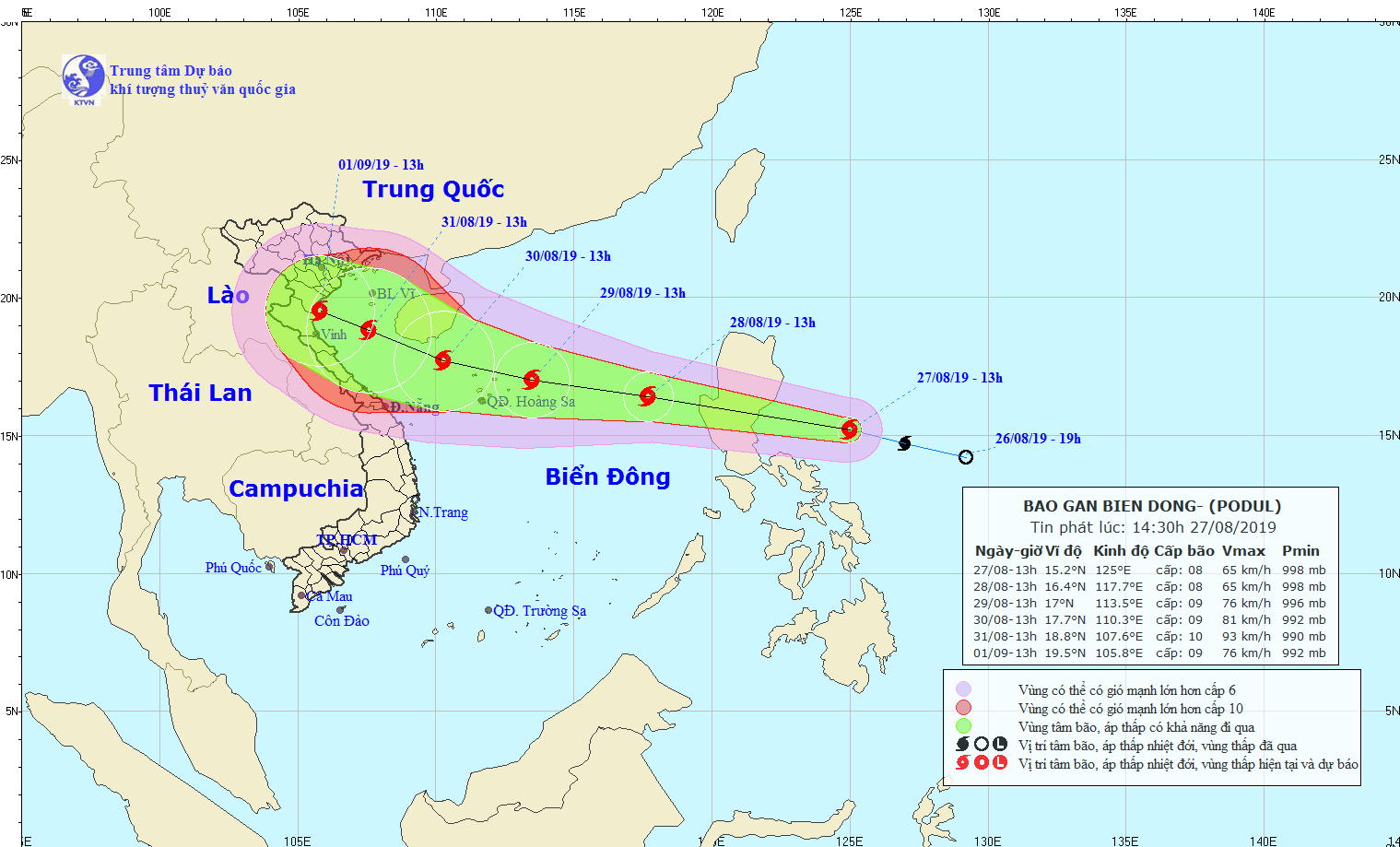 |
| The path of Typhoon Podul. Photo: North Central Vietnam Meteorological and Hydrological Station. |
Forecast for the next 24 hours,The storm is moving rapidly in a west-northwest direction, traveling approximately 30 km per hour, and is expected to enter the South China Sea by tomorrow morning. At 13:00 on August 28th, the storm's center will be located at approximately 16.4 degrees North latitude and 117.7 degrees East longitude, about 580 km east of the Paracel Islands. The strongest winds near the storm's center will be at level 8 (60-75 km/hour).level 10 surge.
Due to the influence of the storm, from early tomorrow morning, the eastern sea area of the North East Sea will experience stormy weather, strong winds of force 6-7, reaching force 8 near the storm's center, with gusts up to force 10; the sea will be very rough.
Dangerous areas in the South China Sea over the next 24 hours.(Strong winds of force 6, gusts of force 8))North of latitude 14.5 degrees North; East of longitude 115.5 degrees East.Level of natural disaster risk: level 3.
Over the next 24 to 48 hours,The storm is moving mainly in a west-northwest direction at a speed of 15-20 km/h and is likely to intensify. By 13:00 on August 29th, the storm's center will be located at approximately 17.0 degrees North latitude; 113.5 degrees East longitude, just above the sea east of the Hoang Sa archipelago. The strongest winds near the storm's center will be at force 8-9 (60-90 km/h).level 11.
Over the next 48 to 72 hours,The storm is slowing down, moving west-northwest at 10-15 km/h, and is likely to intensify. By 13:00 on August 30th, the storm's center will be located at approximately 17.7 degrees North latitude and 110.3 degrees East longitude, about 100 km south-southeast of Hainan Island (China). The strongest winds near the storm's center will be at level 9 (75-90 km/h).level 11.
During the next 72 to 96 hours, and then from the following 96 to 120 hours,The storm is moving in a west-northwest direction at a speed of 10-15 km per hour and has the potential to intensify further.
Level of natural disaster risk due to storms: level 3.
This afternoon, August 27th, the Standing Office of the Provincial Steering Committee for Disaster Prevention and Search and Rescue issued a dispatch regarding the response to Typhoon Podul. The dispatch stated:
To proactively respond to the storm, the Standing Office of the Provincial Steering Committee for Disaster Prevention and Search and Rescue requests the Chairpersons and Heads of the Steering Committees for Disaster Prevention and Search and Rescue in districts, cities, and towns; the Provincial Military Command, the Provincial Border Guard Command, the Provincial Police Department, provincial departments and agencies; the Directors of irrigation and hydropower companies in the province, and other relevant units to implement the following:
1. For areas at sea:
- Inform captains and owners of vessels operating at sea about the location, direction of movement, and development of the storm so they can escape or avoid entering the dangerous area. The dangerous area in the East Sea over the next 24 hours (strong winds of level 6, gusts of level 8): North of latitude 14.0 degrees North; East of longitude 118.0 degrees East, and will be adjusted according to forecast bulletins.
- Organize and closely monitor the departure of vessels and maintain regular contact with ships operating in the storm-affected area to promptly handle any adverse situations that may arise; inspect and guide the anchoring of ships at ports, especially in anchorage areas around islands; organize guidance to ensure the safety of tourists along the coast.
2. For inland areas: Inspect the safety of irrigation and hydroelectric dams, dikes, and areas at high risk of landslides and flash floods to prepare response plans in case of emergencies.
3. Prepare personnel and equipment for rescue and relief operations when required.
4. The Provincial Radio and Television Station, Nghe An Newspaper, Ben Thuy Coastal Information Station, and other mass media outlets should increase broadcasting time and news coverage on the storm's developments and the directives of the Provincial People's Committee and the Provincial Steering Committee for Disaster Prevention and Search and Rescue, so that people are aware and can proactively prevent and respond to the storm.
5. Maintain a strict 24/7 duty roster and regularly report to the Standing Office of the Provincial Steering Committee for Disaster Prevention and Search and Rescue./.

