A secluded nature destination on Dinh Mountain.
With its fresh air and lush greenery, Suoi Tien quickly caught the attention of many tourists as the beaches became too crowded.
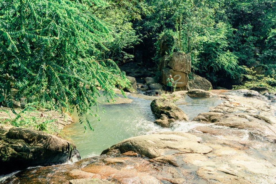 |
Suoi Tien (Fairy Stream) on Dinh Mountain promises to be a popular destination during the holidays. Photo: Twinspiration |
When traveling to Ba Ria - Vung Tau, tourists often seek out famous beaches or wander around the city to enjoy local specialties. With the upcoming April 30th - May 1st holiday, Vung Tau beaches will become even more crowded.
Tired of crowds, many tourists are starting to seek out destinations with quiet spaces and fresh air to fully enjoy their holiday. That's why images of Tien Stream on Dinh Mountain have been widely shared on travel forums and groups in recent days.
Where is Suoi Tien (Fairy Stream) located?
Suoi Tien is located on Dinh Mountain, in Tan Thanh District, Ba Ria City, Ba Ria - Vung Tau Province. It's only about 80 km from Ho Chi Minh City, closer than Vung Tau City, making it easy for visitors to make a day trip by motorbike, bus, car, or short road trip.
 |
The paved road leading to Tien Stream is lined with lush greenery. Photo: @chauvn |
Starting from Ho Chi Minh City, visitors can follow National Highway 51 towards Vung Tau city. Upon reaching the Long Son intersection, turn left onto Truong Son road and continue for about 2 km until you see a paved road on the left. Follow this paved road to the end to reach Tien Stream.
According to Quang Vinh, an experienced hiker at Suoi Tien, the paved road leading to the stream is quite steep and has many curves, requiring a steady hand on the handlebars. "The most suitable means of transport is a motorbike, as there are sections of road that are too narrow for a car. Tourists should choose motorbikes with an engine capacity of 110 cc or more for easier climbing. When approaching steep curves, you should frequently honk your horn to avoid larger vehicles."
Additionally, Ms. Ta Thi Minh Thoa (a resident of Ba Ria city) added that tourists often confuse Suoi Tien (Fairy Stream) with Suoi Da (Stone Stream) because both are located on Dinh Mountain. However, Suoi Tien is near the summit of the mountain, while Suoi Da is right at the foot of the mountain, so the routes are different. The road to Suoi Tien is the same road leading up Dinh Mountain.
A hidden "green paradise" in the mountains.
Dubbed a hidden "green paradise" atop the mountain, Tien Stream boasts diverse vegetation with a layer of fine moss at its base and rows of pine trees providing shade all around.
Compared to other destinations in Ba Ria - Vung Tau, Tien Stream still retains its pristine beauty, largely undeveloped for tourism and relatively unknown to many. Here, visitors won't be overwhelmed by crowds; they can leisurely sit by the stream and breathe in the fresh, clean air.
 |
Lush green scenery at Tien Stream. Photo: Twinspiration |
Suoi Tien (Fairy Stream) has five tiers. The stream originates from the peak of Dinh Mountain, over 500 meters high, flowing rapidly down the rocky slopes and collecting into bathing areas at each tier. Because it's located near the mountain peak, the water in Suoi Tien is cool and clear, so transparent that you can see the bottom. On both banks of the stream are large, flat rocks where visitors can sit and enjoy the scenery, listening to the birdsong mingling with the gentle sound of the stream flowing through the crevices.
Travel blogger Twinspiration, the owner of the viral photos taken at Suoi Tien (Fairy Stream) on travel groups, shared that the fresh, cool air and the vibrant sounds of the mountains and forests made her feel relaxed and relieved of stress after days of work.
"Visitors can prepare their own camping tents to fully enjoy a day here. Around Tien Stream, there are many other small streams to explore. In addition, trekking from the foot of the mountain and conquering the steps leading straight to the summit is also an exciting experience for those who like to explore nature," the male travel blogger added.
    |
Suoi Tien is best visited on hot days. Photo: Twinspiration, @earn_narat |
Suoi Tien is at its most beautiful during the rainy season, from May to October. At this time, the water flows strongly, crashing against the rocks and creating a white foam. The dry season, from November to April, is when visitors should avoid going, as the stream often dries up or has very little water.
Besides familiar activities like swimming in the stream, trekking, and sightseeing, the pine forest at Suoi Tien is also a popular spot for picnics and overnight camping. The quiet atmosphere, free from noise and phone signals, and lacking modern amenities, allows visitors to immerse themselves in nature and listen to the unique sounds of the mountains and forests at night.
"Our group brought some ready-made ingredients and BBQ equipment for a picnic. The feeling of sitting amidst nature and enjoying a hot BBQ is also more enjoyable. After the picnic, visitors should collect their trash to keep Suoi Tien clean," shared visitor Pham Hong Quan.
  |
Visitors can camp overnight and have a BBQ in the pine forest. Photo: Hnadov, Vuong Ai Boi |
Currently, there is no entrance fee to Suoi Tien, so visitors can freely enjoy themselves all day long. At the foot of the mountain, there are several eateries with prices ranging from 250,000 VND per person. In the middle of the mountain, there are also a few thatched huts for resting, with rental prices ranging from 150,000 to 200,000 VND per hut.
Combine trekking to the summit of La Ban.
Visitors exploring Suoi Tien often combine their trip with a trek to La Ban peak on Dinh Mountain. The trekking route is quite gentle, with few obstacles, suitable for many people, including those with less than optimal physical fitness. Tall trees with mottled yellow moss cover both sides of the path, and a forest floor covered with dry leaves, create a dense forest environment.
To reach La Ban Peak, visitors need to follow a small trail 700-800 meters long, located to the right of the path leading to Hang Mai Pagoda on Dinh Mountain. The trekking time usually lasts from 45 minutes to an hour, depending on the fitness level of each visitor.
  |
The path to the summit of La Ban is quite beautiful and easy to follow. Photos: @maiii.lee, @onigiri.trang |
In fact, La Ban Peak is a flat rock 500 meters high, surrounded by open spaces, and was once used as a helicopter landing pad by the US in the past. Currently, the coordinate markings indicating the four directions (East, West, South, North) are still preserved.
Standing on top of La Ban Peak, visitors can observe almost the entire Long Son peninsula and several nearby locations such as Cai Mep port, Ganh Rai bay, and Vung Tau sea. Even Can Gio can be seen in the distance.
 |
The stunning view from the top of La Ban Mountain dispels all fatigue. Photo: Ha Nguyen |
In addition, there are many beautiful temples around Dinh Mountain such as Hang Pagoda, Tay Phuong Pagoda, Dai Tong Lam Pagoda… which tourists can combine with their visit.

