Cold air strengthens, tropical depression causes heavy rain and thunderstorms along the South Central Coast
(Baonghean.vn) - This evening and tonight (November 18), this cold air mass will affect the northeastern and north central provinces, then affect the northwestern region and some places in the central central region.
Early this morning (November 18), storm number 8 weakened into a tropical depression.
At 4 o'clock,The center of the tropical depression is located at about 11.0 degrees North latitude; 110.0 degrees East longitude, about 130km East Southeast of Phan Rang (Ninh Thuan), about 240km East Northeast of La Gi (Binh Thuan). The strongest wind near the center of the tropical depression is level 7 (50-60km/hour), gusting to level 9. The radius of strong wind level 6, gusting to level 8 is about 70km from the center of the tropical depression.
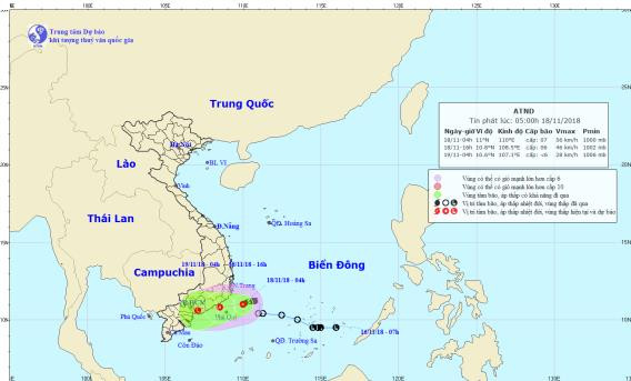 |
| Path and location of the tropical depression. Photo: National Center for Hydro-Meteorological Forecasting |
Forecast for the next 12 hours,The tropical depression is moving westward at a speed of about 10km per hour. At 4pm on November 18, the center of the tropical depression was at about 10.8 degrees North latitude; 108.5 degrees East longitude, right on the coast of the provinces from Binh Thuan to Ba Ria-Vung Tau. The strongest wind near the center of the tropical depression is level 6 (40-50km/h), gusting to level 8.
In the next 12-24 hours,The tropical depression moved in the West Southwest direction, traveling 10-15km per hour and weakened into a low pressure area. At 4:00 a.m. on November 19, the center of the low pressure area was at about 10.6 degrees North latitude; 107.1 degrees East longitude, on the mainland along the coast from South Binh Thuan to Ba Ria-Vung Tau.
Due to the influence of the tropical depression weakening from storm No. 8, this morning (November 18), in the sea areas of provinces from Ninh Thuan to Ba Ria-Vung Tau, there are strong winds of level 6-7,jerky9, waves 2-4m high; rough sea.
From noon and afternoon today (November 18), coastal areas of Ninh Thuan, Binh Thuan, and Ba Ria-Vung Tau provinces will havewindlevel 6-7.
Dangerous areas in the East Sea in the next 24 hours(strong wind level 6 or higher): from latitude 9.0 to 12.5 degrees North; west of longitude 111.5 degrees East.Marine disaster risk level: Level 3.
Due to the influence of the tropical depression weakening from storm No. 8, during the day and tonight (November 18), in the coastal provinces of South Central, Southern Central Highlands and Southern regions, there will be moderate rain, heavy rain, and in some places very heavy rain and scattered thunderstorms, with common rainfall from 50-100mm.
From now until November 19, there will be a flood on rivers in the South Central region. During this flood, the flood peak on rivers from Khanh Hoa to Binh Thuan will be at level BĐ1-BĐ2. There is a high risk of landslides and flash floods in mountainous areas, and inundation in low-lying areas and urban areas in the above areas.Disaster risk level due to heavy rain, flooding, flash floods, landslides: level 1-2.
Cold air boost
Currently (November 18):The cold air mass is continuing to move south.
Forecast:Tonight (November 18), this cold air mass will affect the northeastern and north central provinces, then affect the northwest and some places in the central central region. From November 19, in the northeastern provinces, the weather will turn cold with the lowest temperature commonly 19-22 degrees, in the mountainous areas it will turn cold with temperatures of 15-17 degrees.
In the Gulf of Tonkin from tonight (November 18), the Northeast wind will gradually increase to level 6, gusting to level 7; rough seas.
Due to the influence of the cold air strengthening combined with the high-altitude wind convergence zone, from tonight and tonight (November 18), in the North there will be rain, showers and thunderstorms in some places; from November 19, the provinces from Thanh Hoa to Thua Thien Hue will have rain, moderate rain and thunderstorms in some places; in thunderstorms there is a possibility of tornadoes, lightning, hail and strong gusts of wind.