Floods rising rapidly on Ca River, landslide warnings in more than 60 communes of 7 mountainous districts
(Baonghean.vn) - Currently, the water level in the upper reaches of Ca River and Hieu River is on the rise. According to the forecast of the North Central Hydrometeorological Station, there is a high risk of landslides and flash floods in more than 60 communes in 7 mountainous and midland districts.
According to the latest news received from the North Central Hydrometeorological Station, last night (August 29) and this morning, in Thanh Hoa and northern Nghe An there was rain, scattered moderate to heavy rain and thunderstorms, rainfall as of 7:00 a.m. today (August 30) was generally 30 - 60mm; in Nghe An and Ha Tinh there were scattered showers and thunderstorms in some places.
Forecast,Today and tonight (August 30), the low pressure trough with its axis through the North connecting with the center of the low pressure area over the North is active and moving westward, so Thanh Hoa and northern Nghe An will still have moderate to heavy rain, especially in the midlands and mountainous areas of Thanh Hoa, there will be places with very heavy rain and thunderstorms; southern Nghe An and Ha Tinh will have showers and scattered thunderstorms.
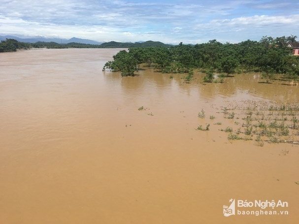 |
| On August 20, the mulberry fields on both sides of the Lam River were submerged in water due to the flood from upstream. Photo: Archive |
Rainfall today and tonight (August 30) in Thanh Hoa and northern Nghe An is likely to reach: 50 - 100mm, some places over 100mm.
Currently, the water level on the upper reaches of Ca River and Hieu River is on an upward trend. Water level at 04:00 on August 30 on Ca River at Muong Xen: 139.45m; at Thach Giam: 67.87m; at Con Cuong: 27.27m at Dua: 18.74m (
It is likely that in the next 12 hours, the water level on the upper reaches of Ca River and Hieu River will continue to rise. The forecast water level at Muong Xen is at: 140.80m,at Thach Giam at level: 68.90m, at Con Cuong at level: 28.00m, at Dua at level: 18.90m (
Warning,High risk of landslides and flash floods in mountainous and midland areas of districts and communes. Specifically as follows:
1. Ky Son (20 communes):Bac Ly, Bao Nam, Bao Thang, Chieu Luu, Doc May, Huoi Tu, Huu Kiem, Huu Lap, Keng Du, Muong Ai, Muong Long, Muong Tip, My Ly, Na Loi, Na Ngoi, Nam Can, Nam Can, Pha Danh, Ta Ca, Tay Son.
2.Tuong Duong (15 communes):You Khuong, Luong Minh, Luu Kien, Mai Son, Nga My, Nhon Mai, Tam Dinh, Tam Hop, Tam Quang, Tam Thai, Thach Giam, Xieng My, Yen Hoa, Yen Na, Yen Tinh.
3. Con Cuong (7 communes):Binh Chuan, Cam Lam, Chau Khe, Don Phuc, Lang Khe, Mau Duc, Mon Son.
4.Que Phong (9 communes):Chau Kim, Chau Thon, Dong Van, Hanh Dich, Nam Giai, Nam Nhoong, Quang Phong, Thong Thu, Tri Le.
5.Quy Chau (8 communes):Chau Binh, Chau Hanh, Chau Hoan, Chau Hoi, Chau Nga, Chau Phong, Chau Thuan, Dien Lam.
6. Quy Hop (3 communes):Chau Cuong, Chau Thanh, Nam Son.
7.Anh Son and National Highway 7Section from Nam Can to Con Cuong town, National Highway 48C, National Highway 48D, Provincial Roads 544 and 532.