
The land and the people along the Nam Non River.
(Baonghean) - On the last day of the year, we followed the task force on a border patrol trip along the Nam Non River. As the early morning mist still blanketed the vast green forest, and the sound of wild roosters heralded the changing of the day, we boarded our boat and headed upstream… This three-day patrol gave us many experiences and profound insights into life, the land, and the human connection in the border mountains…
(Baonghean) - On the last day of the year, we followed the task force on a border patrol trip along the Nam Non River. As the early morning mist still blanketed the vast green forest, and the sound of wild roosters heralded the changing of the day, we boarded our boat and headed upstream… This three-day patrol gave us many experiences and profound insights into life, the land, and the human connection in the border mountains…
The task force, comprising Border Guards, the District Military Command, and various commune-level departments, was led by Major Tran Quoc Nam, Deputy Commander of My Ly Border Guard Post, with Mr. Kha Ngoc Minh, Chairman of My Ly Commune People's Committee, as deputy head. The afternoon before departure, we were briefed on several regulations, including the warning that the trip would be extremely arduous and everyone needed to be well-prepared in terms of health, spirit, and endurance. The following morning, the 15-member task force boarded two motorboats and traveled upstream on the Nam Non River to carry out border patrol duties.
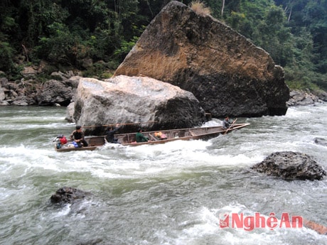 |
| Crossing the Nam Non waterfall. |
From the Xieng Tam ferry landing, two boats started their engines and glided swiftly across the calm water. They passed Yen Hoa village (also known as Xang To), home to an ancient, moss-covered tower, a relic of a once flourishing culture. Some believe this tower dates back to the Tran Dynasty, erected to define the boundaries and territories of Dai Viet. In other words, the tower served as a cultural and spiritual landmark, contributing to the affirmation of national sovereignty. After passing Yen Hoa village, crossing a long stretch of river and two waterfalls, the boats reached Xang Tren village (also known as Xang Nua). Xang Tren village nestled beside the Nam Non River, with its ancient stilt houses, lush gardens, and bustling riverbanks filled with boats. In the Thai language, "xang" or "xieng" ("xieng") signifies the administrative, cultural, social, and economic center of a region. In My Ly, there are three villages located next to each other that all share this meaning: Xieng Tam, Xang To, and Xang Nua. This proves that My Ly was once a central hub, a bustling center of a large border region of Nghe An province. From this, we can see that the legend about the ancient tower in Xang To village being a "cultural and spiritual landmark" has some basis.
Upon arriving at Xang Tren village, the locals came out to the boat dock to welcome us. Everyone tried their best to invite the group to visit their homes, offering each person a handful of freshly cooked sticky rice and a glass of wine as a token of friendship to warm our hearts before our departure. Bidding farewell to the people of Xang Tren with fondness, we boarded the boat, started the engine, and continued our journey. As the boat passed the Xang Tren Border Guard Checkpoint, the soldiers came to the riverbank to wave goodbye to the group and promised to visit again on our return. From here, the Nam Non River began to flow swiftly, with large and small rapids crashing against the rocky banks, testing the skill of the boatmen. First was Canh Cap (in Thai, meaning a waterfall of sharp rocks like closely spaced teeth), with countless sharp rocks arranged in a battle formation in the middle of the river. To ensure safety and reduce weight when navigating the rapids, everyone had to disembark and navigate along the jagged cliffs, leaving only two people on the boat to steer. The person at the back held the rudder, while the person at the bow held the oars and acted as the "navigator." The roar of the engine, working at full power, mingled with the deafening sound of the waterfall. The boat weaved through the crevices of the rocks, then climbed upstream along the swirling waterfall, finding a calm spot to dock so the crew could board and continue upstream…
Throughout the journey, the boat had to navigate dozens of waterfalls, including nearly a dozen large ones that required navigating rocky banks on foot. Besides Cành Cạp, there's Cành Lẹt with its many stacked rocks; Cành Xạt with its three streams and countless submerged rocks; Cành Ngôn with a large rock surrounded by three smaller rocks blocking the flow; Cành Hón (Nhím Waterfall) with a rock lying horizontally across the stream, resembling a hedgehog bristling its quills in self-defense. Cành Mai and Cành Mỡ are equally dangerous. But particularly noteworthy are Cành Sạc (Cày Waterfall) and Cành Sộc (Mối Waterfall). The locals cleverly imagined these two waterfalls together, forming a mortar and pestle pair. Cành Sạc, though short, is steep, so the water cascades down in a white column, with a roaring sound at the foot of the waterfall. As for the length of Cành Sộc waterfall, it can be said that no other waterfall on the Nậm Nơn river can match it. The waterfall stretches for about 2km, and in the middle of the river there are hundreds of whirlpools created by the slope of the flow and thousands of scattered rocks.
Walking, climbing, and crawling on the rocks along the bank, everyone was drenched in sweat, even in the middle of the cold days. Each time we navigated the rapids and dodged the rocks, we saw the anxiety on the faces of the boatmen. Because just one small mistake, a misstep, or an overly forceful turn of the rudder could send the boat crashing into the rocks and shattering it, leaving lives entirely at the mercy of the river and the rocks. But they were people born and raised by the Nậm Nơn River, the river that nurtured them, so they knew every channel, cliff, and whirlpool like the back of their hand. Watching the boatmen navigate the Nậm Nơn rapids, I was reminded of the image and skill of the boatmen on the Đà Giang River, as depicted by the writer Nguyễn Tuân in the 1960s. Then I suddenly thought, years ago, when Nguyen Tuan went on a field trip to Northwest Vietnam and wrote the famous essay "The Ferryman of the Da River," if he had gone to the headwaters of the Nam Non River, he would surely have written another masterpiece of essays.
Our boat crossed the Huoi Mai gorge, the border dividing the territories of Vietnam and Laos. From here, the Nam Non River also belongs to both countries; the right bank is Vietnam, while the left bank belongs to Laos. On the right bank are three Thai villages: Pieng Tip, Cha Nga (My Ly commune), and Keng Du (Keng Du commune). On the left bank are the villages of Xop Duong, Canh Co, Xop Cang, Xop Xan, and Pieng Xang, belonging to Muong Quan district, Hua Phan province (Lao People's Democratic Republic). Both sides share the same river and waterfalls, creating a very close and friendly relationship. Transportation and trade are quite convenient, and men and women from both sides easily find spouses. Every time our boat passed by, the people of the Lao villages would come to the riverbank and wave, as if welcoming long-lost brothers.
At noon, the delegation visited Cha Nga village. After lunch, the village management board gave a preliminary report on the socio-economic situation and security in the area. It was encouraging to see that the lives of the villagers were stable, security and order were maintained, and there were no instances of illegal migration or the re-cultivation of opium poppies. Relations with villages across the border were well-maintained, and visits to relatives and the exchange of goods proceeded smoothly. Here, the delegation...We were warmly and hospitably welcomed. Around the jar of rice wine, everyone held hands, sang, and danced rhythmically to the lam vong dance. In the quiet night, we listened to the breath of the earth and sky, the gentle murmur of the river, the lullaby of the wind, and the song of the forest trees.
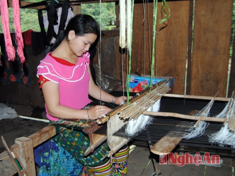 |
| Young American girl Ly by the loom. |
That morning, the group met and split into two teams. One team patrolled by land to check security and order and replant opium poppies. The other team continued upstream along the Nam Non River to the area bordering Keng Du commune and agreed to meet at Cha Nga at 3 PM. We were assigned to the river patrol team. Boarding the boat, we crossed Canh Sac, Canh Soc, and Canh Mo, and near noon, our boat docked at Keng Du. There, the border guards of the Keng Du Checkpoint ( thuộc Keng Du Border Guard Post) were already waiting. In front of the checkpoint, the red flag with a yellow star proudly fluttered in the wind. Across the river lay the territory of our neighboring country with its vast primeval forests. That afternoon, we enjoyed a delicious meal of catfish caught from the river and cooked in sour sauce, stir-fried vegetables, and boiled beans. These were specialties of the villages and streams at the headwaters of the Nam Non River.
After resting and exchanging information, the delegation from My Ly commune boarded a boat and headed downstream to Cha Nga to be on time for the meeting. The road patrol team was waiting at the riverbank, and many villagers came to see them off. The two boats started their engines, and hands waved goodbye. The village girls playfully splashed water on the guests, hoping that this feeling would remind them of the land and people of Cha Nga. The water soaked through our clothes in the freezing weather, but we still felt warm from the kindness of the people living at the headwaters of the Nam Non River.
The boat sped down the waterfall, leaving behind countless rocky "battlefields" and roaring whirlpools. Near evening, the group stopped at the Xang Tren Border Guard Station (part of the My Ly Border Guard Post) for dinner and to socialize with the officers and soldiers. By the warm campfire, we listened to the stories and feelings of the soldiers guarding the border. The villagers of Xang Tren came to join us, their songs, flutes, and pipes echoing joyfully. The melodies of life and soul blended with the melodies of the Nam Non River and the border mountains and forests. All together, they formed a harmonious chorus praising the peaceful life in every village, mountain, and stream…
Cong Kien


