Immense on the most beautiful road in western Nghe An
(Baonghean) - The Tay Nghe An route, nearly two hundred kilometers long, connecting Que Phong to Ky Son, is considered the most beautiful road in the border region of Nghe An, passing through three of the poorest districts in the country.
The road now marked 'National Highway 16', is the most beautiful road in the Western region of Nghe An. I realized this perhaps a little too late. In more than 5 years and hundreds of trips to this land, this was the first time I traveled its entire length. Each hamlet, village, mountain, and stream had bright and quiet colors when the sky and earth changed to summer.
We chose Tri Le commune (Que Phong) as the starting point for our trip to explore the most beautiful road in Western Nghe An, which is also the first milestone of the national highway. The feeling of fatigue from the first heat wave of the season, which the hydrometeorological agency measured at up to forty degrees in some places, seemed to have passed away with relief. Just a day later, the temperature had dropped to almost half. The rains came and went in a flash. Just two days later, the sky turned bright and sunny again. The weather in this land is also fickle, capricious, and unpredictable to the extreme.
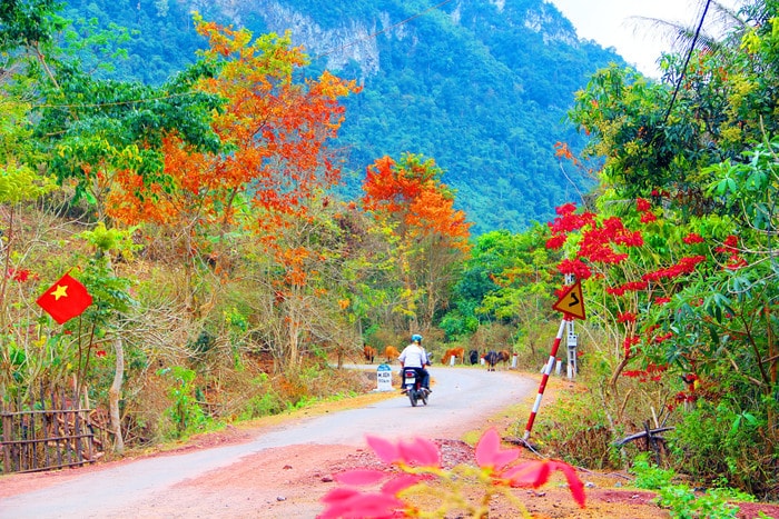 |
| Red leaf road connecting Xop Tu village, My Ly commune (Ky Son). Photo: HV-HP |
The sudden sunshine and rain seem to be a “medicine” to support the rice fields. Just two days ago, the rice on the terraced fields was still green, now it has begun to show signs of maturity. As the Thai people call it, the rice is in the “com lam” stage. The scent of rice powder makes the afternoon air fragrant. It is so pleasant. Tri Le is one of the border communes that grows the most rice in the Western Nghe An region, with a tradition that can easily be traced back hundreds of years.
Every time I pass through this land, I remember the story of Mr. Vi Phuc, originally from Mon Son commune (Con Cuong). This is also a border commune with several hundred hectares of rice fields. However, the story of this old man who once held the position of District Party Secretary is not about rice cultivation. He said that Tri Le was formerly called Muong Che Le. This was the stopping point of many Thai families when migrating to the mountainous region of Nghe An from the Northwestern and Western Thanh Hoa provinces. From here, they spread out in many directions. The farthest stopping point was Mon Son commune where, more than 80 years ago, his Vi family contributed to the uprising in response to the Nghe Tinh Soviet movement and the birth of the first Party cell in Western Nghe An. Tri Le today has become the most multicultural area of Que Phong district, home to three indigenous ethnic groups: Thai, Mong, and Kho Mu. Muong Che Le also only remains in a half-true, half-false legend.
It took the “iron horse” more than an hour to “carry” the two of us across Tri Le land. It was just the beginning of summer, the bamboo forests on both sides of the road were in bloom. This plant only blooms once and it was also its last glorious days before it withered. In the eyes of the photojournalist, bamboo blooming was a rare moment, even though he traveled almost all year round to the villages in the mountainous areas, but he rarely had the chance to see it.
Passing through the Tri Le Heaven Gate and also the last Mong village of Tri Le. "We are about to reach Nhon Mai commune (Tuong Duong)", my friend's voice echoed in the whistling wind. At this time, we had just passed the Heaven Gate and started to go downhill. The asphalt road wound along the deserted mountainside as if it was leading us to a deserted land. Very rarely did we meet a motorbike going in the opposite direction. The deserted mountains and forests were wild and unspoiled but not monotonous. Every now and then, we had to stop in front of clumps of red-hot cassia trees. This season, the cassia trees change their leaves, the forest turns red, just a breeze passing by and clumps of leaves scatter and fly away, leaving behind each bare branch. Only about a month later, after a few summer rains, new shoots will sprout up on the seemingly withered branches. Nature is truly amazing!
Since the road that the government used to call the Western Economic Road was built, the appearance of the villages along it has changed in a strange direction. Village names like Na Hi and Co Ha, which were very remote, have now become easier to travel to. The road to Huoi Co, the most remote village in Nhon Mai commune, can now be traveled by motorbike. People no longer have to spend 2 days to get to the provincial center like before. If you want to go to "Ban Vinh" (the way the highlanders call Vinh City), you can now take a bus. Something that no one dared to think of just five or seven years ago.
Na Hi village is a green and quiet picture. Each small stilt house along both sides of the road seems to be carved into the mountainside. Next to the village are green terraced fields. In just over a month, when passing by here and the rice season is ripe, many people will have the feeling of being lost in a miniature Cang Chai rice field, enchantingly beautiful.
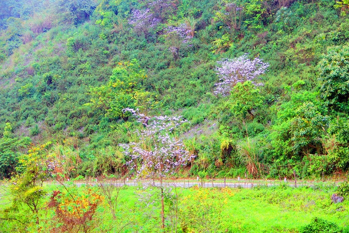 |
| White Bauhinia flowers bloom on Pha Bun mountain range. Photo: HV-HP |
The smooth road took us through Nhon Mai, Mai Son, Tuong Duong district, then through My Ly, Huoi Tu, and Pha Danh communes. Ta Ca commune (Ky Son) is the last point of National Highway 16. Each kilometer is an interesting experience of natural scenery. That is the road with the bright red color of Sang Le leaves and Poinsettia leaves in Xop Tu village, My Ly commune. Clumps of white Bauhinia flowers bloom on Pha Bun mountain range, Huoi Tu commune. Bauhinia flowers and the white color of reeds evoke a melancholy and lightness like the clouds covering the top of Pha Bun mountain all year round.
Strangely enough, on the colorful road passing through remote villages, the hardships of making a living suddenly disappear like the morning mist. Then, when I sit facing the wall of my house or when I close my eyes to wait for sleep to come, the colorful pictures appear in my mind...
| The Western Nghe An Road has a total length of 184km and 41 bridges, passing through the districts of Que Phong, Tuong Duong, Ky Son, costing 2,127 billion VND. This is a key route of Nghe An province in the project "Socio-economic development of the Western Nghe An province to 2020" which was put on the priority investment list by the Prime Minister. The road was inaugurated at the end of 2015, expected to create a lever to promote socio-economic development in the Western region, improve the material and spiritual life of ethnic minorities; is a route connecting the border belt road with Nghe An province, making an important contribution to socio-economic development, maintaining the national defense and border security. |
Huu Vi - Ho Phuong
| RELATED NEWS |
|---|