The heat is gradually easing in the Central provinces.
(Baonghean.vn) - The low pressure area in the West with the southwest wind zone causing the foehn effect is gradually weakening, today the Central provinces continue to experience widespread heat. However, the highest temperature during the day is commonly 35-38 degrees, some places over 38 degrees.
The low pressure area in the West with the southwest wind causing the foehn effect is gradually weakening. Today (July 7), heat waves will still occur in the Northern Delta with the highest temperature during the day commonly 35-36 degrees.
 |
| Peaches ripen in Western Nghe An. Photo: Archive |
The Central provinces continue to experience widespread heat waves, with the highest temperature during the day commonly ranging from 35-38 degrees, with some places exceeding 38 degrees. The time with temperatures above 35 degrees is from 10am to 7pm. From July 8, the heat waves will end in the North and gradually decrease in the Central provinces.
Meanwhile, due to the influence of the low pressure area gradually strengthening in the northern region of the Northern provinces, last night and early this morning, July 7, in the northwestern provinces and the northern mountainous areas, there was moderate rain, heavy rain, and very heavy rain in some places such as: Mu Cang Chai (Yen Bai) 25mm, Luc Yen 88mm, Bac Me 27mm, Bac Quang 46mm, Dong Van (Ha Giang) 35mm, Cao Bang 32mm, Trung Khanh (Cao Bang) 49mm,...
Currently (7/7):The low pressure area continues to exist and gradually strengthen over the northern region of the Northern provinces.
Therefore, it is forecasted that from today (July 7) to July 9, in the North and Thanh Hoa, there will be widespread showers and thunderstorms, in mountainous and midland areas there will be moderate to heavy rain; in particular, Lai Chau, Lao Cai, Ha Giang, Tuyen Quang and Yen Bai provinces will have very heavy rain and thunderstorms (heavy rain will be concentrated at night and early morning). During thunderstorms, there is a very high possibility of tornadoes, whirlwinds and strong gusts of wind.
Disaster risk level due to heavy rain: level 1; in Lai Chau, Lao Cai, Ha Giang, Tuyen Quang and Yen Bai provinces: level 2.
Warning:Heavy rain in the Northern provinces will peak from today (July 7) to July 9, after which the rain may last for many days.
WARNING FOR STRONG WINDS AND HIGH WAVES AT SEA
Currently (7/7):The southwest monsoon in the South causes heavy thunderstorms in the Central and Southern East Sea (including the Truong Sa archipelago), the sea areas from Binh Thuan to Ca Mau, Ca Mau to Kien Giang and the Gulf of Thailand; in the Southern East Sea (including the Truong Sa archipelago) and the sea areas from Binh Thuan to Ca Mau, there are strong southwest winds of level 6, sometimes level 7, gusting to level 9; rough seas.
Forecast:Due to the influence of the strong southwest monsoon, in the South China Sea (including Truong Sa archipelago), there is strong southwest wind at level 6, gusting to level 9; rough seas, waves from 2-4m high. The sea area from Binh Thuan to Ca Mau has strong southwest wind at level 6, sometimes at level 7, gusting to level 9, waves from 2-3m high; rough seas.
In the Central and Southern East Sea (including Truong Sa archipelago), the sea areas from Binh Thuan to Ca Mau, Ca Mau to Kien Giang and the Gulf of Thailand continue to have heavy thunderstorms.Disaster risk level: level 1.
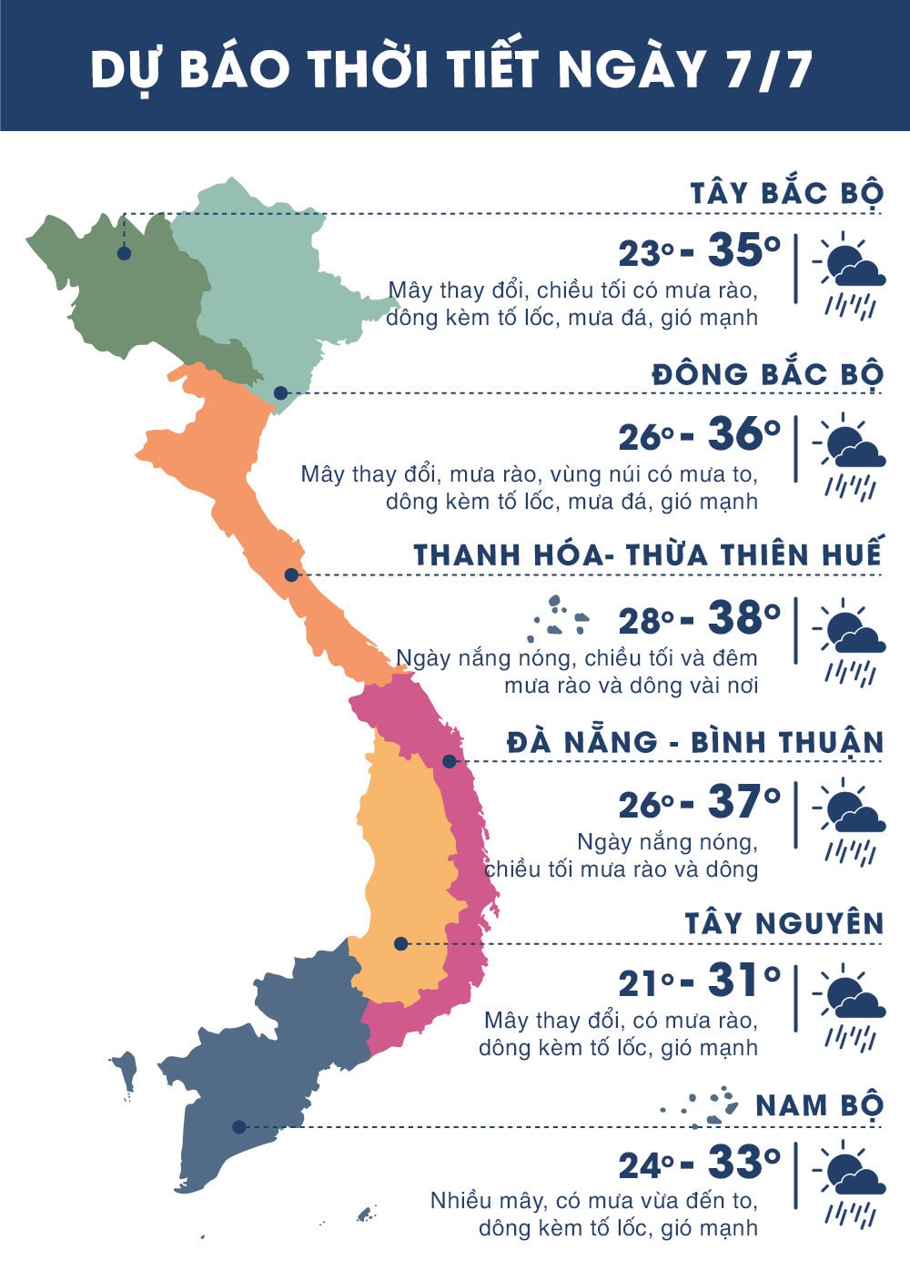 |
| Temperatures in regions across the country on July 7, 2018. Source news.zing.vn |


.jpeg "Thời tiết Nghệ An ngày 13/8: Ngày trời nắng, có nơi nắng nóng")
