Heatwave and extreme weather forecasts in Nghe An
(Baonghean.vn) - Mr. Tang Van An - Head of Hydrometeorological Forecasting Department, North Central Hydrometeorological Station had an interview with Nghe An Newspaper reporter about the hot weather situation and weather forecasts in Nghe An province.
PV:Currently in Nghe An the weather is developing in the direction of widespread heat. Can you give more specific information about the weather forecast for the coming time in Nghe An?
Mr. Tang Van An:From May 4-5, most localities in Nghe An province have been experiencing heat waves. In particular, some localities have experienced severe heat waves with temperatures above 40 degrees Celsius, for example, in Quy Chau and Quy Hop districts, the temperature sometimes reached over 41 degrees Celsius, and in Tuong Duong on May 4, it reached 41.7 degrees Celsius.
 |
Mr. Tang Van An - Head of Hydrometeorological Forecasting Department, North Central Hydrometeorological Station. Photo: HT |
According to the forecast of the North Central Hydrometeorological Station, in the next few days (from May 5 to 7), heat and severe heat will continue to occur widely in most districts, cities and towns in Nghe An, with common temperatures ranging from 37 - 40 degrees Celsius.
In particular, some localities may have temperatures from 41-42 degrees Celsius such as: Ky Son, Tuong Duong, Quy Chau, Quy Hop, Que Phong, Anh Son, Thanh Chuong, Tan Ky, Nghia Dan,... Particularly in Cua Lo town area, the temperature is about 36-38 degrees Celsius.
In the coming time, it is forecasted that heat waves will likely increase from around May to July 2023, with more and more intense hot days likely to appear than in the same period in 2022.
However, comparing the temperature in the past 15 years, 2023 is not expected to be the hottest year. For example, on the same day, May 4, the time in 2012 when the highest temperature in Nghe An reached 42 degrees Celsius in Quy Hop district, in 2023, on May 4, the temperature in Nghe An still maintained the threshold of 41-42 degrees Celsius, but the hot area expanded more than in 2012.
It is forecasted that after a period of hot weather, from mid-May 2023, the weather in Nghe An will likely change to a lower temperature, with rain, and even tropical depressions and storms.
PV:Why do mountainous areas often have higher temperatures than plains and coastal areas? Do you have any notes about the weather in these areas?
Mr. Tang Van An: The recent weather developments in Nghe An show that in addition to being hot and sunny with higher temperatures than coastal plains, mountainous areas often experience extreme weather phenomena such as tornadoes, hail, and strong gusts of wind.
There are many causes, but one of the important factors affecting weather developments in mountainous areas is due to the characteristics of geographical location and typical terrain such as many high wind-blocking mountains, many valleys, wind-facing positions... When cloud areas form and move from other regions to mountainous areas, they are affected by high wind-blocking mountain terrain, or by sudden changes in temperature and air pressure between sub-regions, which can easily lead to tornadoes, whirlwinds, strong gusts of wind...
PV:How does the North Central Hydrometeorological Station conduct weather forecasting and warnings? Can you tell us more about longer-term weather forecasts?
Mr. Tang Van An:Regarding the North Central Region Hydrometeorological Station, Nghe An currently has 9 meteorological observation points, serving the measurement of wind and temperature factors... located in the centers of districts, cities and towns. In addition, the province also has a system of nearly 100 rain gauge stations and 11 hydrological stations managed and operated by the North Central Region Hydrometeorological Station and other agencies and units such as irrigation agencies, hydroelectric plants...
 |
Staff of the North Central Region Hydrometeorological Station process weather warning information. Photo: HT |
After having the weather forecast results, the Station will send the results to relevant agencies and units such as: Provincial Office of Natural Disaster Prevention, Search and Rescue, departments, branches, press and radio agencies... to promptly inform the people.
According to the forecast results that we have analyzed, after 3 days of peak heat, from May 8 to the end of May 14, Nghe An is forecasted to have widespread rain, almost all districts, cities and towns. Especially note that on May 7, there is a possibility of rain with gusts of wind and tornadoes in some localities such as: Nghia Dan, Thai Hoa, Que Phong, Quy Hop, Con Cuong, Tuong Duong and Ky Son.
In a longer-term forecast, we see that from May to July 2023, Nghe An is likely to experience ENSO phenomenon..Specifically, the ENSO phenomenon will continue to remain neutral from now until about June 2023 with a probability of 80-90%; after that, the sea surface temperature in the central Pacific region will continue to increase and lean towards the El Nino phenomenon, meaning that the number of hot days will occur more than the number of rainy and stormy days.
ENSO is an acronym for the words El Nino Southern Oscillation to refer to both El Nino and La Nina phenomena.
According to weather forecast data updated on April 14, 2023, by the end of May 2023, storms and tropical depressions are unlikely to appear in the East Sea, and will likely appear around mid-June.
However, due to the development of the ENSO phenomenon, according to our records at the time of information update on May 5, 2023, a tropical depression has appeared near the East Sea, which is likely to enter the East Sea in May 2023, not excluding the possibility of strengthening into a storm. To forecast the development of the depression more accurately, we will monitor and update the latest developments.
Forecasting meteorological, hydrological and oceanographic trends from August to October 2023, the ENSO phenomenon will continue with forecasts that regional sea surface temperatures will continue to increase gradually and El Nino status will be established with a probability of 55-65%, and is likely to last until the first months of 2024.
Therefore, it is forecasted that from August to October 2023, the number of storms or tropical depressions in the East Sea region is likely to be lower than the average of many years in the same period (it is forecasted that there will be about 6-7 storms or tropical depressions active in the East Sea region) and impact the North Central region. Beware of storms with complex developments in both trajectory and intensity.
Regarding heat, it is forecasted that heat will continue to occur in August 2023, with the intensity of heat likely to be more severe than in the same period in 2022. Then there will be a tendency to decrease around September 2023.
PV:Regarding weather forecast information, what do you think people should pay attention to?
Mr. Tang Van An:We will always strive to provide the most accurate weather forecasts, to help people grasp the weather situation to serve their lives, activities as well as production and business as we have done in the past.
The combination of intense heat and extreme weather patterns such as thunderstorms, tornadoes, and hail will impact the environment, living conditions, infrastructure, and socio-economic activities. Storms and tropical depressions cause strong winds and large waves, affecting activities at sea; in addition, heavy rain, heat, thunderstorms, tornadoes, and hail during the transitional season can negatively affect production activities and public health in the area.
To prevent or minimize damage caused by extreme weather, people need to update and grasp weather forecast information in a timely manner to take preventive measures. Forecasts may not be absolutely accurate, however, having advance preparation will create initiative, limiting damage with the motto "prevention is better than cure".
On hot days, people should note that in the late afternoon and at night there is a possibility of thunderstorms, during thunderstorms there is a high possibility of dangerous weather phenomena such as: tornadoes, strong gusts of wind, hail, lightning...
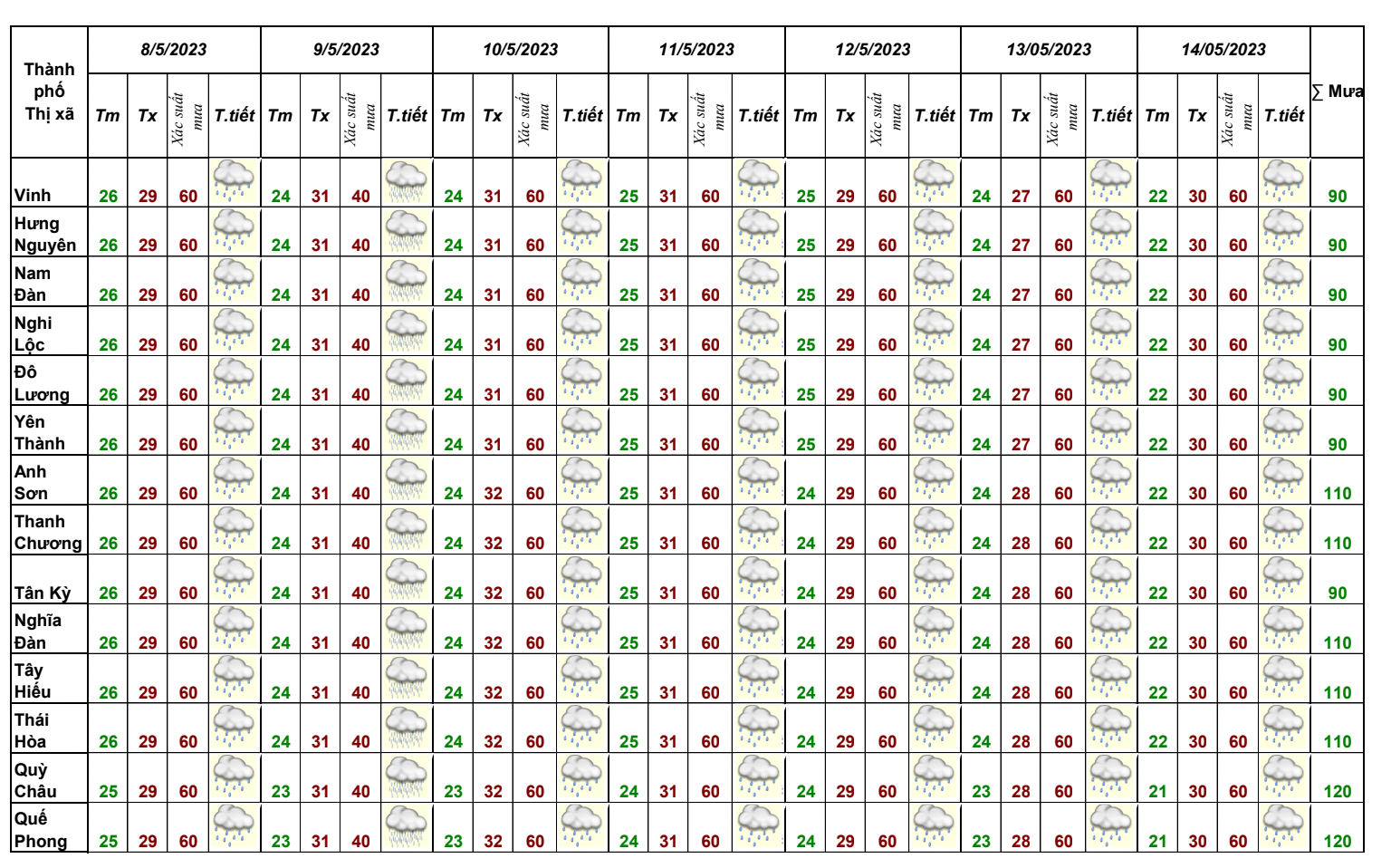 |
Weather forecast for some areas of Nghe An from May 8-14. Photo: North Central Hydrometeorological Station |
PV:Thank you!
From February 2023 to present, the North Central region has been affected by 5 cold air waves (including 04 Northeast Monsoon waves - cold air with cold and dry air masses).
During this time, the North Central region experienced two heat waves, severe heat waves on March 21-24 and April 4-5. Notably, the heat wave on March 21-24, specifically:From March 21-24, the Nghe An-Ha Tinh region experienced severe heat, with some places experiencing particularly severe heat with the highest temperature commonly ranging from 36.5-39.5 degrees Celsius, and some places higher than 40 degrees Celsius such as Tuong Duong 41.3oC on March 23, vsurpassing the historical March data in 20 years (2000-2022). Historical data recorded a high of 40.8 degrees Celsius on March 31, 2014.
Phenomena of tornadoes, lightning, hail:From February 2023 to now, the North Central region has experienced 5 tornadoes with hail.
