September 14th: Emergency storm warning (Typhoon No. 3)
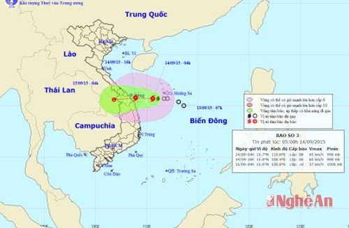
(Baonghean.vn) - At 4:00 AM on September 14th, the typhoon's center was located at approximately 15.7 degrees North latitude and 110.6 degrees East longitude, in the sea southwest of the Hoang Sa archipelago, about 220km east of the Da Nang-Quang Ngai coast. The strongest winds near the center of the typhoon were at level 8 (60 to 75 km per hour), with gusts of level 9-10.
According to the forecast of the North Central Vietnam Meteorological and Hydrological Station,within the next 12 hoursThe storm is moving mainly westward at a speed of 10-15 km per hour. By 4 PM today (September 14th), the storm's center was located at approximately 15.8 degrees North latitude and 108.9 degrees East longitude, in the coastal waters off Da Nang and Quang Ngai. The strongest winds near the storm's center reached level 8 (60 to 75 km per hour), with gusts of level 9-10.
 |
| 1 |
Over the next 12 to 24 hoursThe storm continued to move westward at a speed of 10-15 km per hour, making landfall in the Da Nang - Quang Ngai area and weakening into a tropical depression. The tropical depression then continued further inland and weakened into a low-pressure area. By 04:00 on September 15th, the center of the low-pressure area was located at approximately 15.6 degrees North latitude; 106.8 degrees East longitude, over southern Laos. The strongest winds at the center of the low-pressure area decreased to below level 6 (i.e., below 40 km per hour).
Today (September 14th)In the northern part of the North Central region, there will be scattered rain and showers; in the southern part, there will be moderate to heavy rain, with some areas experiencing very heavy rain and thunderstorms.
From tonight until September 18th, the area of heavy rain will expand to the entire North Central region, with moderate to heavy rain and thunderstorms.
Total rainfall during this period: 100-200mm in the northern part of the region; 200-400mm in the southern part of the region, with some areas reaching 500mm.
Be prepared for the risk of flash floods and landslides in mountainous areas, and flooding in low-lying areas. Disaster risk warning level: level 2.
The next news bulletin will be broadcast at 09:00 on September 14th.
Ha Chi

