People of Nghe An and their sovereignty over the sea and islands.
(Baonghean.vn) - Of the first five works written about "Golden Sand Beach," four were authored (or co-authored) by people from Nghe An. This is truly a great source of pride for the land and people of Nghe An.
Many geographical works written about the Paracel and Spratly Islands bear the immense contribution of intellectuals from Nghe An province. These are all original texts of great scientific, historical, and legal value, contributing significantly to affirming Vietnam's territorial and maritime sovereignty over the Paracel and Spratly Islands.
The Paracel and Spratly Islands, collectively known as "Golden Sandbanks," are two archipelagos located in the South China Sea that have been under Vietnam's sovereignty since ancient times. This is the folk name given by the people of the Southern region of Vietnam to these two large coral archipelagos in the South China Sea. Later, some scholars translated this phrase into Chinese characters as Hoàng Sa, Hoàng Sa Chử, etc. It wasn't until the end of the 18th century, with the development of maritime science in general and marine surveying and mapping in particular, that the "Golden Sandbanks" were separated into two distinct archipelagos.
The Paracel Islands are in the north, known to Westerners; the Spratly Islands are in the south, known as the Spratly Islands. The names "Xisha," "Nansha," and "Sansha," coined by the Chinese in the 20th century to refer to Vietnam's "Golden Sandbanks," are merely deceptive terms used to justify their encroachment and long-term occupation. Vietnam possesses ample historical evidence to assert its sovereignty over both the Paracel and Spratly Islands from ancient times, in accordance with current international law.

Vietnam's sovereignty over the Hoang Sa and Truong Sa archipelagos has been affirmed early and consistently by prominent figures from Nghe An province.
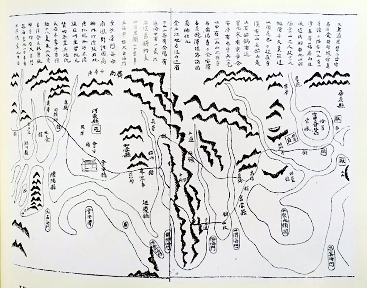
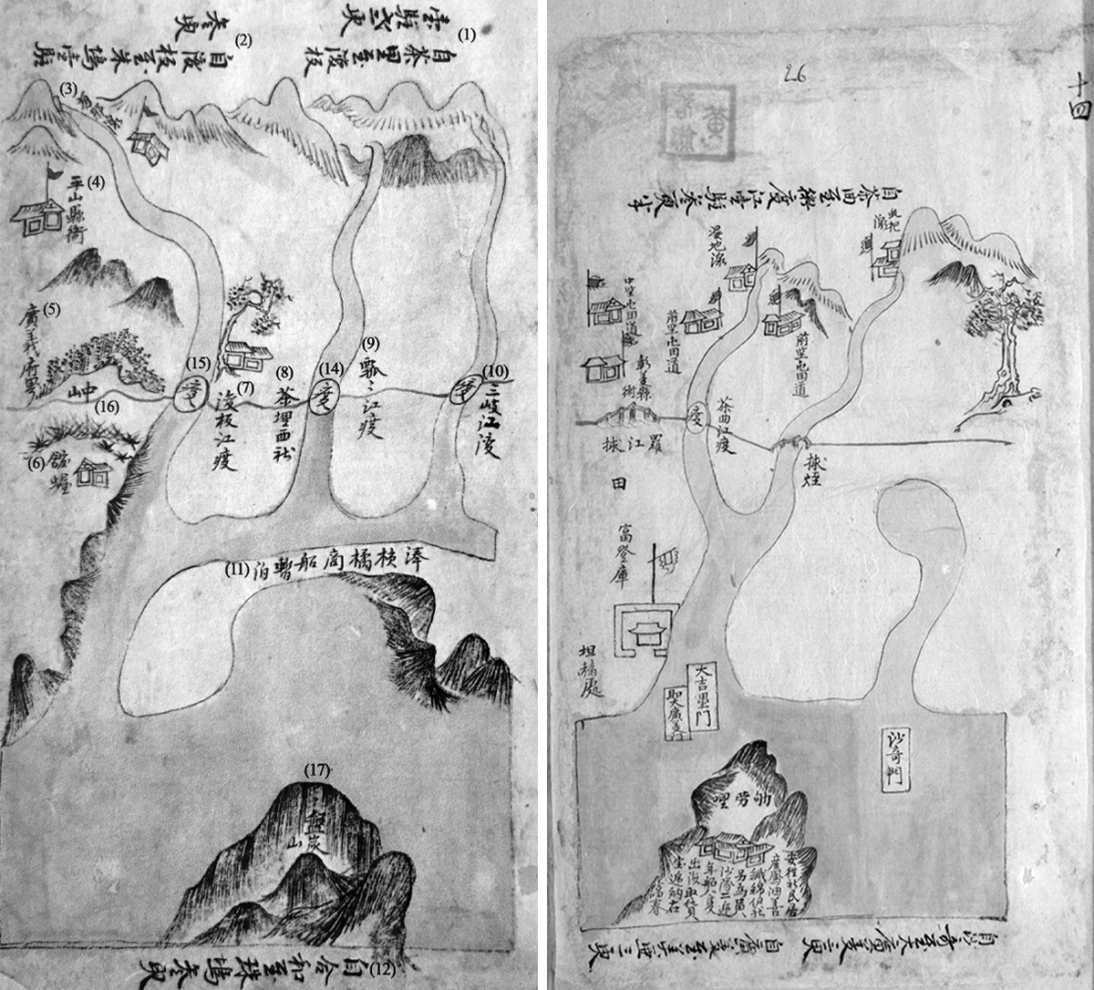
From the very first workComplete Collection of Maps of the Four Regions of Southern Vietnamby Confucian scholar Do Ba Cong Dao, written in 1686, to the workYear of the Horse, Southern Mapby Duke Doan, Bui The Dat, written in 1774, orQuang Thuan Dao History CollectionWritten by Dr. Nguyen Huy Quynh in 1774.Continuation of the Chronicle of Dai VietIn addition to works by Hoàng Giáp Phạm Nguyễn Du (co-authored) and later official histories of the Nguyễn dynasty, the aforementioned intellectuals from Nghệ An province all have clear records and descriptions of Hoàng Sa and Trường Sa.
WorkComplete Collection of Maps of the Four Regions of Southern VietnamThis was the first work in Vietnam (and indeed the world at that time) to mention the Vietnamese feudal state's ownership of the Hoang Sa and Truong Sa archipelagos. Most notably, the work, compiled and executed by Confucian scholar Do Ba Cong Dao on the orders of Lord Trinh and presented to him during the Chinh Hoa era (1680-1705), can be considered a state document – an official state-level work.
And also from the name "Golden Sandbank," the colloquial name that the people of Dang Trong (Southern Vietnam) gave to the two archipelagos of Hoang Sa and Truong Sa today, later scholars of Dang Ngoai (Northern Vietnam) transliterated it into Chinese characters as "Hoang Sa Chu" or simply "Hoang Sa," and officially used this name in famous historical and geographical works of that time.Dai Nam Thuc Luc, Dai Nam Nhat Thong Chi, Dai Nam Nhat Thong Toan Do.
Following that, Duke Doan Bui The Dat painted the set.Year of the Horse, Southern MapIt dates back to before the 35th year of the Canh Hung era and was completed and presented to Lord Trinh before the southward expansion in 1774. After capturing Phu Xuan, this was the first time the Trinh army had seized the capital of the Dang Trong government and brought in officials to govern, and it was also thanks to this that people from Dang Ngoai were free to learn about and write about Dang Trong so extensively for the first time.
Therefore, many scholars in Northern Vietnam, in addition to their political and military activities, collected materials from scholars in Southern Vietnam and conducted fieldwork in the localities of Southern Vietnam to write valuable geographical works, including...Quang Thuan Dao History CollectionAccording to Dr. Nguyen Huy Quynh's work, compiled between approximately 1774 and 1785, the Hoang Sa Fleet appeared and operated early on, at least before the years 1774-1785.
The authors were all born and raised in Nghe An, a province not under the administrative control of the "Golden Sandbanks," yet they always considered the territory and maritime boundaries of Dang Trong (Southern Vietnam) as an integral part of the nation and its people. Therefore, they felt a responsibility to protect and document these areas early on, meticulously, seriously, continuously, and consistently. This demonstrates that the management of the "Golden Sandbanks" under the Nguyen lords was a very tight and systematic system, and more importantly, it reflects the Vietnamese people's awareness of their territory and maritime boundaries, regardless of political regime or viewpoint, affirming their sovereignty over the Hoang Sa and Truong Sa archipelagos even before the 17th century.
The geographical location, natural conditions, and management and exploitation of the Hoang Sa and Truong Sa archipelagos by Vietnam have been objectively and consistently documented by prominent figures from Nghe An province.
The scholar Do Ba Cong Dao pioneered the recording and description of "Golden Sand Beach" in a truthful and comprehensive manner:"It rises up in the middle of the sea (approximately between) the Dai Chiem estuary and the Sa Vinh estuary. It takes a day and a half to cross the sea from Dai Chiem estuary to here, and half a day from Sa Ky estuary to here."The area range is:"About 400 miles long and 200 miles wide," the natural conditions are: "Whenever there is a southwest wind, merchant ships from countries near the shore drift here, and when there is a northeast wind..."The related activity was: "Merchant ships sailing offshore also drifted here and all died of starvation. All goods and supplies were left behind"; and most importantly, it affirmed the Nguyen dynasty's control and dominance over the Southern region of Vietnam."Every year, in the last month of winter, the Nguyen family brings 18 boats here."and the exploitation of the sea and islands by the Vietnamese people is"In order to obtain goods, most of what was obtained were gold, silver, currency, and weapons.".
This work provides very basic information about the geographical location, natural conditions, and the sovereignty of the Phu Xuan government over the "Golden Sandbank". The annotations here are quite accurate, although some figures regarding length, width, and distance from the shore are approximate. This is understandable because the scholar Do Ba Cong Dao drew the map while acting as a "spy" for the Trinh lord's government, thus having to work in secrecy and lacking many tools and resources. Nevertheless, such information demonstrates the seriousness and meticulousness of the author.
Year of the Horse, Southern MapThe drawing and annotation of "Golden Sandbank" are extremely simple and lack any annotations other than the three Nôm characters "Golden Sandbank," thus omitting any information about its geographical location, natural conditions, management, and the establishment of sovereignty by the Phu Xuan government, as well as any notes about the Hoang Sa Fleet. This is understandable, as it is a "Map" rather than a "Book" (maps and books).
Furthermore, this work was purely military in nature and not a geographical or historical work. Therefore, the author, Duke Doan Bui The Dat, focused only on describing and drawing points closely related to military operations such as forts, ramparts, and guard posts. This map set served primarily military purposes, so why was "Golden Sandbank" drawn and annotated in such detail?
We know that, under the Nguyen lords, the Hoang Sa fleet was established to exploit economic benefits. In addition, the Hoang Sa fleet was tasked with being ready to respond to any external invasion. This clearly shows that the management of Hoang Sa and Truong Sa under the Nguyen lords reached a high level of perfection, both in terms of system and regulations. Therefore, when Doan Quan Cong drew...Year of the Horse, Southern MapIt was impossible to overlook such an extremely important area as the "Golden Sand Beach".
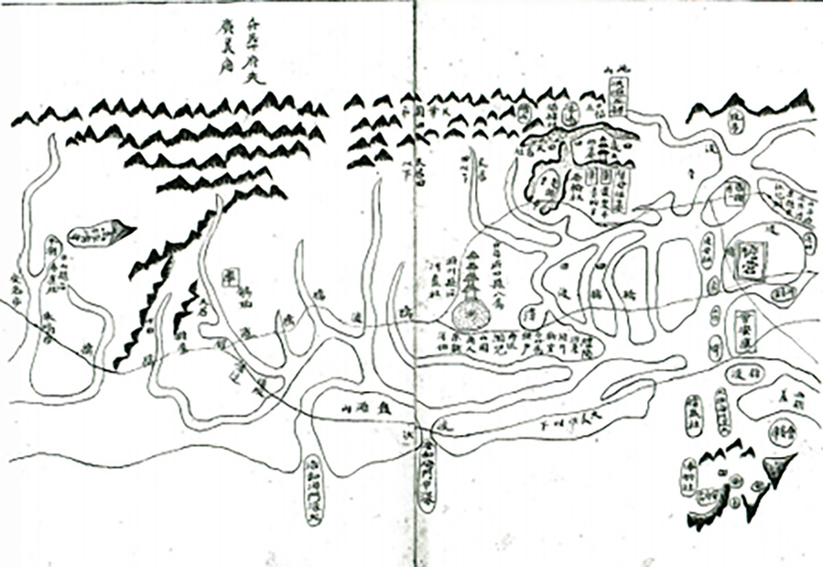
NextQuang Thuan Dao History CollectionCompared to Dr. Nguyen Huy Quynh's work, this book is the most complete and detailed.Complete Collection of Maps of the Four Regions of Southern VietnamThe scholar Do Ba Cong Dao's work stands out because it provides detailed information about the homeland of the Hoang Sa fleet. Dr. Nguyen Huy Quynh clearly recorded the geographical location, route, and travel time."From Dai Chiem Gate to Hap Hoa Gate is 4 hours, from Hap Hoa Gate to Chau O Gate is 3 hours, from Chau O to Da Dien is 3 hours, from Da Dien to Dai Quang Ngai Gate is 3 hours", more specifically"Beyond this gate lies Ly Son Island, and on the mountain there are people living in a village called An Vang."And the extremely important information is that it specifically names the homeland of the Hoang Sa naval squadron, as well as providing detailed information about the squadron's activities."This village has a fleet called the Tsar's Second Fleet; every year, eighteen ships set sail to the land of the Tsar to obtain goods and gold."From this, we see a new development: the Hoang Sa Nhi team from An Vang commune, after collecting all goods and products, had to return and hand them over to the capital, Phu Xuan.
This detail clearly shows that Hoang Sa Nhi always had to comply with the regulations and institutions of the government, both in terms of organization and operation. So why was it mentioned in the two previous works?Complete Collection of Maps of the Four Regions of Southern VietnamandYear of the Horse, Southern MapWhy were these records not yet documented? We see that Confucian scholars Do Ba Cong Dao and Doan Quan Cong Bui The Dat had to carry out their recording and descriptive work secretly and far from the capital of Phu Xuan, so they could not fully grasp the schedule set by the Nguyen lords for the naval fleet. But after the Trinh army captured Phu Xuan, Confucian scholars from the North, such as Doctor Nguyen Huy Quynh, were free to study the system and conduct fieldwork to record their findings.
The aforementioned works are personal notes, while atContinuation of the Chronicle of Dai VietThe official history, compiled by the scholar Pham Nguyen Du, is the official history of the State. Thus, through the records about the Hoang Sa and Truong Sa archipelagos in this official history, we can see that it contains information about the Hoang Sa and Truong Sa archipelagos.Continuation of the Chronicle of Dai VietThis marks the first time that information about "Golden Sand Beach" has been officially included in the national history system.
The works of Nghe An intellectuals are consistent with the historical records of many other countries regarding Vietnam's sovereignty over the Hoang Sa and Truong Sa archipelagos.
In 1696, the bookOverseas ChronicleThe writings of Venerable Thach Liem Thich Dai San (1633 - 1704) regarding the Paracel and Spratly Islands are as follows:“...the sand dunes lie straight along the coast, stretching from northeast to southwest; the high dunes rise vertically like walls, the low sands are level with the sea surface; the sand is dry and hard as iron, a ship would surely be destroyed if it struck; the sandbank is hundreds of miles wide, its length immeasurable, known as the Great Wall of Sand. In the time of the previous king, every year he sent ships to "collect gold, silver, and tools from damaged ships" to sail along the sandbank.”[1].

In addition, many famous Chinese figures have also made similar records. For example, in the book...Maritime Map Chronicle, bookSea and LandIt is written by Ta Thanh Cao:"The Great Wall of the Spratly Islands (Hoang Sa) is a long stretch of sand in the sea used as a protective barrier to shield the outer borders of Annam (Vietnam)."[2]Numerous Chinese writings directly affirmed that the Paracel and Spratly Islands were under Vietnamese administration and exploitation. This is even more significant considering that at that time there was no territorial dispute, so Chinese authors objectively acknowledged Dai Viet's sovereignty over its territorial waters and island system.
Therefore,Overseas ChroniclegoodSea and Landand many Chinese geographical treatises such asThai Binh Hoan Vu Ky, Du Dia Quang Ky, Phuong Du Thang Lan,…These are all reliable original texts. On the one hand, they acknowledge that the Paracel and Spratly Islands belong to Vietnam's sovereignty, while on the other hand, they clearly state that the southernmost point of China only extends to Hainan Island (Quang Chau). These two factors firmly assert that the Chinese have never been the owners of the Paracel and Spratly Islands.
Besides Chinese writings, European maps and documents also constitute a very important framework for affirming Vietnam's sovereignty over the Paracel and Spratly Islands. Among the oldest maps of the East Sea region is the map set by the Dutchman Van Langren, drawn in 1595. This map set is rich with many clear details as the author depicts the geographical locations of our country. Besides the mainland coastline of Costa da Paracel, opposite Pulocanton (Cu Lao Re) in Quang Ngai province, the Paracel and Spratly Islands are depicted as pennant-shaped flags.[3]For example, a 17th-century map of Asia published by the Dutch East India Company depicts the Paracel Islands as being located on strategically important international maritime routes under Vietnam's sovereignty.
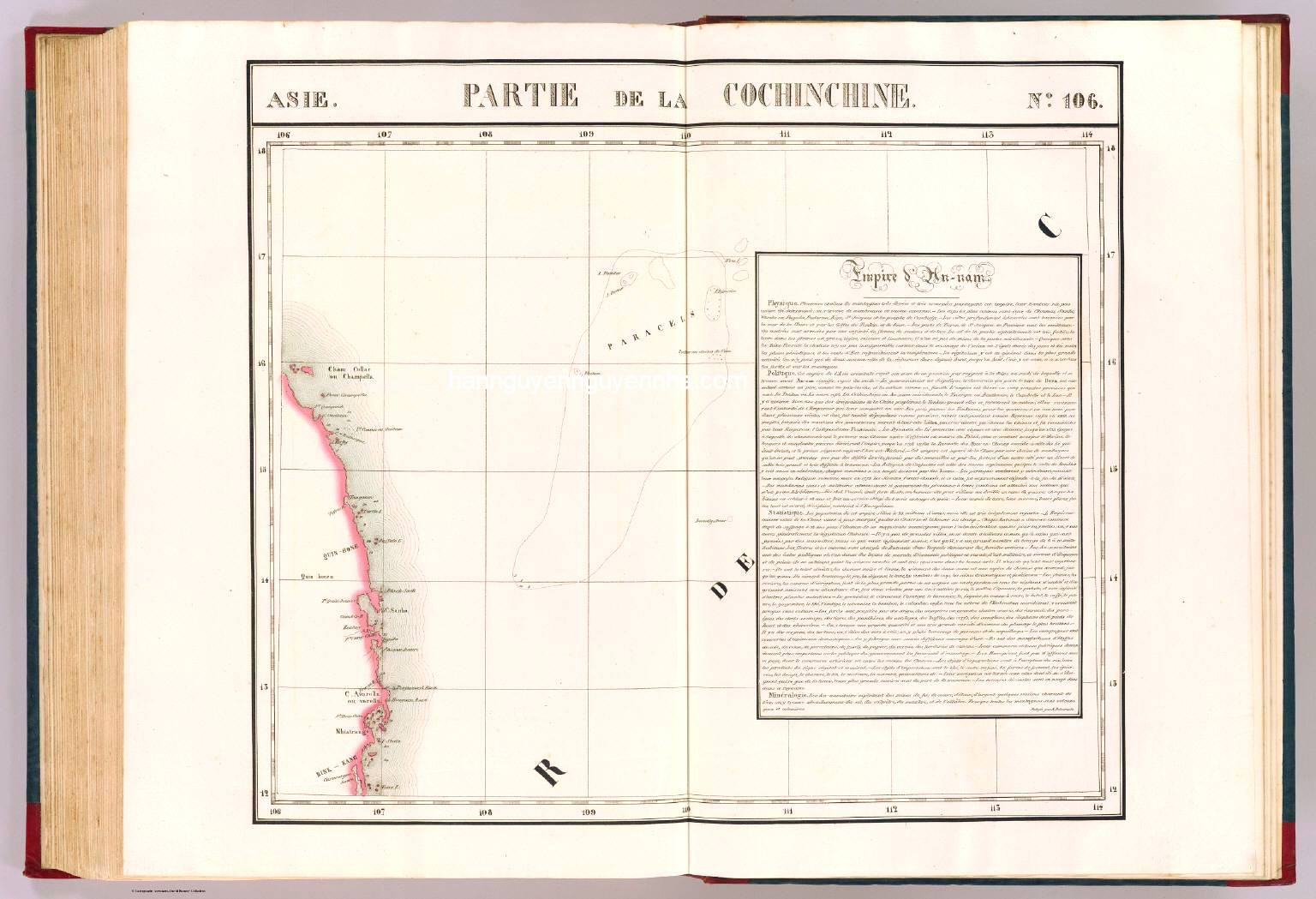
Most notably, there are two sets of maps: Partie de la Cochinchine, included in the Atlas Universel (1827), compiled and published in Belgium in 1827 by geographer Philippe Vandermaelen. This map depicts the Paracel Islands (Hoang Sa) and includes an introduction to the Kingdom of Annam.[4]; and the map Tabula Gesographica imperii Anammitici - Map of the Great Kingdom of An Nam by Bishop Jean Louis Taberd, published in 1838, depicts the Paracel Islands, internationally known as Paracels, located within Vietnamese waters, accompanied by the annotation "Paracels seu Cát Vàng" (Paracels seu Cát Vàng).[5]...Thus, it is clear that Westerners arrived in the Hoang Sa and Truong Sa seas from the late 15th to early 16th centuries, and recognized the sovereignty of the Vietnamese feudal state over these two archipelagos.
Thus, out of the first five works written about "Golden Sand Beach," four were authored (or co-authored) by people from Nghe An. This is truly a great source of pride for the land and people of Nghe An, and also serves as a driving force to further stimulate the creative work of people from Nghe An in the process of integration and innovation in the modern era of the country.
____________
[1] Thich Dai San (2016), Overseas Chronicle, Hanoi University of Education Publishing House, p. 182.
[2] 海錄, 粤東謝清高著, 補讀軒藏版.
[3] Da Nang City People's Committee (2016), Hoang Sa Yearbook, Information and Communications Publishing House, Hanoi.
[4] Da Nang City People's Committee (2016), Hoang Sa Yearbook, Information and Communications Publishing House, Hanoi.
[5] Da Nang City People's Committee (2016), Hoang Sa Yearbook, Information and Communications Publishing House, Hanoi.

