The risk of earthquakes and tsunamis could affect Vietnam.
According to calculations by the Ministry of Natural Resources and Environment, if a 9.2 magnitude earthquake occurs in the Manila Trench area, it could generate tsunamis 10.6m high in Quang Ngai and 5m high in Nha Trang.
Following the tsunami disaster in Indonesia, many people are concerned that earthquakes and tsunamis could affect Vietnam. According to research conducted at the Institute of Geophysics, earthquake source regions in the East Sea and surrounding areas could generate tsunamis that could affect Vietnam's coastal areas. Discovery Magazine is publishing excerpts from an article by Dr. Le Huy Minh, Director of the Earthquake Information and Tsunami Warning Center, and Dr. Nguyen Hong Phuong, Deputy Director of the Center, on this risk.
Earthquake risk
Vietnam is located in the southeastern part of the Eurasian Plate, between the Indian Plate, the Philippine Plate, and the Australian Plate. Because Vietnam's territory is not situated on the edges of these plates, it is less vulnerable to earthquakes compared to other countries in the region such as Indonesia, the Philippines, and Malaysia.
However, within Vietnam's territory and territorial waters exist a complex system of active faults such as: the Lai Chau - Dien Bien fault, the Song Ma fault, the Son La fault, the Red River fault zone, the Song Ca fault zone, and the 109-110 meridian fault.o..., therefore earthquakes occur frequently.
 |
Tectonic seismic map of Vietnam and surrounding areas. |
From the beginning of the 20th century to the present, the northern region has experienced two earthquakes of magnitude 8-9 (6.7-6.8 on the Richter scale), dozens of earthquakes of magnitude 7 (5.1-5.5 on the Richter scale), and hundreds of weaker earthquakes. A typical example is the Dien Bien Phu earthquake in 1935, measuring 6.75 on the Richter scale, which occurred on the Song Ma fault zone.
More recently, the 2001 Dien Bien Phu earthquake, measuring 5.3 on the Richter scale, had its epicenter in Laos, about 20 km from Dien Bien Phu city, causing damage ranging from minor to complete collapse of more than 2,000 houses in the Dien Bien Phu city area.
From 2007 to the present, many earthquakes with magnitudes less than 5.5 on the Richter scale have occurred in Vietnam, such as the earthquake off the coast of Vung Tau - Phan Thiet on November 28, 2007 (5.1 Richter); the earthquake in Do Luong on January 3, 2008 (3.8 Richter)...
The minor earthquakes that have occurred since the Dien Bien Phu earthquake have not caused any loss of life or property; however, they also show that the Earth's crust in the Vietnamese region is not entirely stable. Earthquakes need to be monitored and studied to provide a more comprehensive assessment of seismic activity in Vietnam, contributing positively to the country's development.
Tsunami risk
To date, there is no conclusive evidence to confirm that tsunamis have affected the Vietnamese coast. However, according to research conducted at the Institute of Geophysics, earthquake source zones in the East Sea and surrounding areas that could cause tsunamis affecting the Vietnamese coast include: Riukiu - Taiwan, the Manila Subduction Zone, the Sulu Sea, the Celebes Sea, the Banda Sea, the northern East Sea, Palawan, and the western East Sea. Among these, the Manila Subduction Zone (Manila Deepwater Trench) is considered to pose the highest risk.
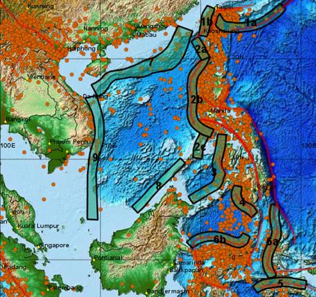 |
Earthquake-generating regions that cause tsunamis can affect Vietnam's coastal areas and islands. |
An 8.2 magnitude earthquake (Figure 9) occurred in this area on May 26, 2006; fortunately, this earthquake did not cause a tsunami.
According to scenarios calculated by the Ministry of Natural Resources and Environment, if an 8.3 magnitude earthquake occurs in the Manila Trench area, it could generate tsunamis 5.2 meters high in Quang Ngai and 2.1 meters high in Nha Trang.
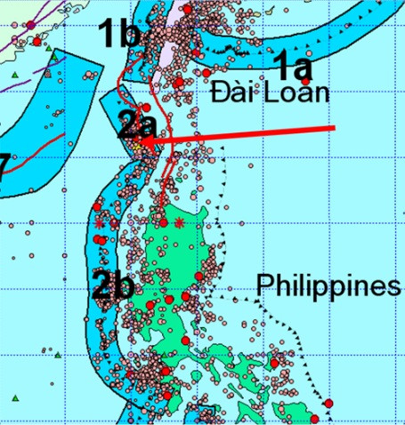 |
The location of the strongest earthquake recorded on the Manila Deep Sea Trench superfault zone is illustrated on the map (arrowhead location). |
An earthquake with a magnitude of 9.2 on the Richter scale in the same area could generate tsunamis 10.6 meters high in Quang Ngai and 5 meters high in Nha Trang, and the tsunami would travel from the Manila Trench to the Vietnamese coast in approximately two hours.
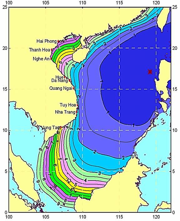 |
Time of tsunami propagation from the Manila subduction zone to the Vietnamese coast. |
Scientifically speaking, earthquakes with a magnitude greater than 6.5 on the Richter scale in ocean areas have the potential to cause tsunamis; therefore, the risk of tsunamis along the Vietnamese coast is real and needs to be addressed.

