
Vietnamese border markers for those who want to conquer them.
The following border landmarks are often included in the itineraries of adventure-seeking travelers.
Milestone 0 A Pa Chai
The landmark is located at the tri-border junction of Vietnam, Laos, and China, in A Pa Chai commune, Sin Thau district, Muong Nha district, about 250 km from Dien Bien province. This is the westernmost point of Vietnam, bordered to the northwest by Yunnan province (China) and to the southwest by Laos. The Ha Nhi ethnic group is the main population in this area, where "the rooster's crow can be heard in three countries."
The 2-meter-high, polygonal granite marker, situated on a 25-square-meter base, sits atop Khoang La San mountain at an altitude of nearly 1,900 meters. Three sides face three different countries, each engraved with the national emblem and name of the respective nation in its language. The placement of the marker here was completed on June 27, 2005.
To climb the border marker, you need a letter of introduction from your workplace or a travel confirmation from your local authority to obtain a permit from the Dien Bien Provincial Border Guard Command. The procedure takes about 2 hours, and working hours start at 8 am. After about 4 hours of trekking through the forest, you will complete your journey to conquer border marker 0 A Pa Chai.
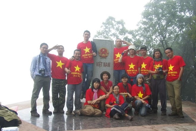 |
Milestone 0 A Pa Chai - where "the rooster's crow can be heard in three countries." |
Milestone 1378
If border marker 0 at A Pa Chai marks the beginning of the Vietnam-China border, then border marker 1378 is the final one. This marker holds a special position, situated at the mouth of the Bac Luan River on Dau Got Island, within the small island cluster of Sa Vi Cape in Tra Co Ward, Mong Cai City, Quang Ninh Province.
The cylindrical marker was built quite high to prevent it from being submerged at high tide. The reconstruction process was arduous due to the weak soil. From November 18, 2009 to the present day, marker 1378 has stood firm amidst the vast ocean.
Reaching this landmark is no easy feat. First, you must obtain permission from the Quang Ninh Provincial Border Guard Command, then the border guard station directly managing the landmark will arrange a time and send an officer to take you there. After reaching the Trang Vy dike and a half-hour boat ride, you will arrive at the large, round landmark with three black, yellow, and red stripes on a white background. From here, you can also see landmark 1377, which is located in Chinese waters.
Milestone 428
Border marker 428, made of granite, is located in Lung Cu commune, Dong Van district, Ha Giang province. Two kilometers away is the deep blue Nho Que River, which divides the border between Vietnam and China. This marker signifies the northernmost point of Vietnam's territory.
The road to border marker 428 is only 2 km long, but the rugged terrain means it takes nearly 3 hours to walk, starting from the end of Xeo Lung village, home to the H'mong people.
Upon arrival, you can see both milestone 426 atop the distant mountain and milestone 427 halfway down the mountain. This trip is often combined with a visit to the Lung Cu flagpole, located about 5 km to the north.
 |
Milestone 428. |
Milestone 79
Border Marker 79 is the highest border marker in Vietnam, located in Mo Si San commune, Phong Tho district, Lai Chau province. The marker was erected on October 24, 2004, at an altitude of nearly 3,000 meters, on the saddle of Phan Lien San mountain peak. This "roof of the border" is situated in what is considered the most rugged area along the Vietnam-China border.
To get here, you need a permit from the Lai Chau Provincial Border Guard Command and must report to the Vang Ma Chai Border Guard Post.
Milestone 42
Vietnam's second highest border marker is Marker 42 in Pa U commune, Muong Te district, Lai Chau province, managed by the Pa Ve Su border guard post. This granite marker, demarcating the border with China, was erected on October 8, 2008, at an altitude of over 2,800 meters. The path to Marker 42 crosses many fast-flowing streams and steep slopes, sometimes taking up to four hours to traverse, with some sections precariously close to the edge of a cliff.
However, there are still stretches of road with picturesque scenery, featuring hills covered in white wildflowers and canopies of trees laden with vibrant red blossoms. Those wishing to conquer the summit of Pu Si Lung will pass through this milestone, marker 42.
Milestone 92
From Lao Cai, follow provincial road 156 towards Bat Xat town, then proceed to A Mu Sung commune. From the center of the commune, travel nearly 20 km along the Red River to reach border marker number 92 on the Vietnam-China border.
This is a confluence point. The Yuanjiang River in China merges with the Lung Po River in Vietnam, becoming the source of the Red River as it flows into Vietnam.
Milestone 92, made of granite, was erected on December 7, 2004, at an altitude of 114 meters and is managed by the Lung Po Border Guard Post. During your journey here, you will witness firsthand the expansive terraced rice fields and the relentless flow of the Red River, its waters heavy with sediment.
Indochina Crossroads landmark
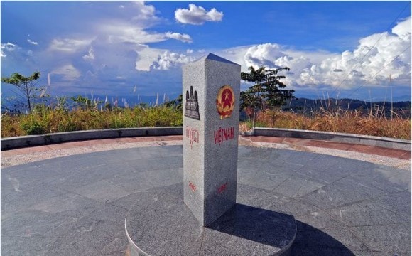 |
The Indochina Tripoint landmark is located in Kon Tum province. |
The unmarked border marker at the Indochina Tripoint is located near the Bo Y border gate in Ngoc Hoi district, Kon Tum province, bordering Ratanakari province of Cambodia and Attapu province of Laos. This marks both the beginning and end of the Vietnam-Cambodia border.
The tri-border marker, made of triangular granite, sits atop a mountain 1,086 meters high. Construction took place from November 29, 2007, to January 18, 2009, with each side engraved with the national emblem and name of each country. Following the Ho Chi Minh Trail from Quang Nam to Kon Tum, after traveling 80 km along a narrow road, you will reach the Bo Y international border gate, and concrete steps will lead you to this marker.
Milestone 240
While traveling through Dong Thap, take time to visit the Thuong Phuoc border gate to see border marker 240, marking the boundary between Vietnam and Cambodia. This is also where the Mekong River flows into Vietnam after originating in Tibet, China, and passing through Laos, Myanmar, Thailand, and Cambodia. All nine major branches of the river form the Mekong Delta, depositing fertile alluvial soil that has enriched the entire southwestern region of Vietnam.
According to Zing.vn


