
Landslides on both banks of the Lam River - Causes and solutions
(Baonghean) - For a long time, the Lam River section flowing through Con Cuong district, especially during the rainy season, has been experiencing erosion of riverbanks due to changes in the river's course. Without timely embankment and protective measures, this will not only result in the loss of significant agricultural land but also threaten bridges, roads, and people's homes.
Following up on the opinions of voters reflected at the 7th session of the 18th term (2011-2016) of the Con Cuong District People's Council, we made a trip upstream along the Lam River to inspect the communes through which the Lam River flows. Along the way, we observed that the current flow of the river has been altered by the rocks and gravel left behind in the middle of the river by the Lang Son Alluvial Gold Mining Company after the previous alluvial gold mining operations. This has caused the river's course to change, leading to erosion of the riverbanks. In Lang Khe commune, Chairman Vi Dinh Tuyen stated: "Previously, the villages of Yen Hoa, Boong, Pieng Khu, and Dong Tien had nearly double the area of riverbanks compared to now."
Since 2008, when the Lang Son Alluvial Gold Company began mining gold without restoring the land, it altered the river flow, causing more severe erosion, resulting in the loss of agricultural land and affecting the livelihoods of the local people. On average, floods cause the loss of several hectares of agricultural land each year. The commune has mobilized the people to build embankments, but due to the strong current, manual embankment construction is ineffective. When we raised this issue in Chau Khe commune, Comrade Nguyen Thanh Binh - Chairman of the commune - said: Like Lang Khe, Chau Khe has two villages, village 2/9 and Bai Gao, with fertile alluvial plains suitable for farming. In recent years, gold mining has altered the river flow, causing erosion.
After each rainy season, these two villages alone lose nearly half a hectare of agricultural land along the river. In Cam Lam commune, where the area of arable land per person is less than 200 square meters, Chairman Le Van Tru said: "For the past few years, after the rainy season, the alluvial plain of Cong village has lost an additional 3,000-4,000 square meters of agricultural land. The villagers have complained, and we have raised the issue at many meetings, but no remedial measures have been implemented. In the past, landslides only occurred during the major rainy season, but now they are threatened almost year-round." An elderly villager in Yen Hoa hamlet, Lang Khe district, couldn't hide his frustration, saying: "For the past few years, thanks to the alluvial plain along the Lam River, Yen Hoa hamlet has yielded 3-4 harvests of corn, peanuts, and beans annually, so our village no longer has to worry about hunger or clear forests for farming. Since the gold mining ships arrived and started excavating the riverbed, they haven't restored the land after mining, leaving behind rocky and gravelly sandbanks in the middle of the river. Previously, the Lam River flowed towards the foot of Cho Hill, where the rocky mountains were strong and resistant to erosion, and the sandbank on the Yen Hoa side expanded year after year. Now, due to gold mining, the flow is shifting to the left bank, causing erosion, especially during major floods when the river 'swallows' the sandbanks. It's heartbreaking to see, officials!"
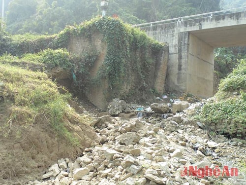 |
| The Khe Dún bridge at the end of Con Cuông town is at risk of collapse at its base if no retaining wall is constructed. |
First and foremost, the damage caused by gold mining upstream of the Lam River in previous years has stripped the river of its poetic beauty. From a clear, gentle river that nourished people and crops on the riverbanks, the river's water is now murky red year-round, further polluted by mercury used in gold refining, rendering it unusable for daily life. While a few years ago there were thousands of fish cages along the Lam River, they have almost disappeared. Even in Con Cuong district, in Tan Hoa village, Bong Khe commune, where hundreds of households used to raise fish in cages a few years ago, the cages are now abandoned because the fish cannot be raised successfully. Many people have had to abandon their boats and nets to work as laborers to make a living.
In the past, the Lam River was a refreshing place to swim in the summer, but for the past few years, no one has dared to swim there because the water is pungent and stinging. Even buffaloes and cows don't dare drink the river water anymore. Previously, the algae in the river were a valuable food source, a specialty of the Thai ethnic people, who would harvest the algae, dry it, and prepare it into dishes. Now, the algae have all died off due to river pollution. The fish population in the river has also lost its food source and is at risk of depletion. An old fisherman in Tan Hoa village (Bong Khe, Con Cuong) said: "In the past, fishermen here used to catch a lot of fish, the saying goes, 'The sea is calm and cool, the waves are strong,' but now almost all the carp, catfish, and many other types of fish like grouper and barracuda are gone."
A dangerous consequence of gold mining, which we mentioned above, is the erosion of alluvial plains along the Lam River. In Lang Khe commune, officials from the People's Committee reported that annually, the alluvial plains along the Lam River in Yen Hoa, Boong, Pieng Khu, and Dong Tien villages are eroded due to the previous gold mining activities of the Lang Son Alluvial Gold Company, which failed to restore the land, leaving rocky islets in the middle of the river. This causes the river to divert towards both banks, resulting in the loss of 2 hectares of alluvial land each year. In Chau Khe commune, gold mining also caused the erosion of over 4,000 square meters of alluvial land in villages 2/9 and Bai Gao during the recent rainy season. In Cam Lam commune, a highland commune with the least arable land, only Cong village has a few hectares of alluvial plains. During the recent flood season, the river's course was diverted, causing the loss of over 3,000 square meters. If the land is not promptly leveled to restore the flow of water, landslides will inevitably continue to occur every rainy season.
While exploiting resources to increase budget revenue is necessary, it must be linked to environmental protection and ensure the well-being and livelihoods of the community. Destructive exploitation like the one described above, which significantly impacts people's lives and destroys the environment, is strictly prohibited.
To combat erosion, the immediate priority is to clear the sandbars in the middle of the river, restoring the flow. Clearing these massive piles of boulders requires machinery; manual labor is not an option. Building riverbank revetments is also necessary in areas at risk of erosion, protecting agricultural land, infrastructure, homes, and people's property.
First, in communes with riverbanks and stream banks at risk of erosion, it is necessary to organize local people to use bamboo, reeds, or sacks filled with stones and gravel to build embankments and plant trees to protect against waves. Based on local experience, planting the "coi" tree, an easy-to-grow species along rivers and streams with a fibrous root system that extends to the water surface, is recommended as it effectively prevents erosion. Strengthening the protection of upstream forests is also crucial to prevent flash floods and landslides.
To restore the pristine beauty of the Lam Giang River, and to keep the melodies of folk songs and ballads alive in people's hearts, in addition to raising public awareness about the role and responsibility of environmental protection, we earnestly hope that managers, policymakers, and relevant agencies will intervene to immediately stop gold mining, restore the river's clarity, protect the agricultural land along its banks, and safeguard the people's access to clean water.
Text and photos:Phung Van Mui
(Con Cuong District Party Committee)


