Super typhoon MANGKHUT gusts above level 17, seas are very rough
(Baonghean.vn) - According to the National Center for Hydro-Meteorological Forecasting, due to the influence of the storm, from tonight (September 14), in the Northeast Sea, there will be stormy rain and strong winds gradually increasing to level 11-12, from tomorrow morning increasing to level 14-15, gusting above level 17.
At 7:00 a.m. on September 14, the center of the super storm is located at about 16.0 degrees North latitude; 126.9 degrees East longitude, about 530km east of Luzon Island (Philippines). The strongest wind near the center of the super storm is level 17 (200-220km/hour).jerk above level 17.
Forecast for the next 24 hours,The super typhoon is moving in a West-Northwest direction, traveling about 25km per hour. At 7:00 a.m. on September 15, the center of the super typhoon was at about 18.0 degrees North latitude; 121.0 degrees East longitude, just north of Luzon Island. The strongest wind near the center of the super typhoon is level 16.jerk above level 17. The range of strong winds of level 6, gusting to level 8 or higher is about 400km from the center of the storm; The range of strong winds of level 10 or higher is about 200km from the center of the storm.
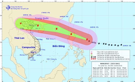 |
| Path and location of storm MANGKHUT. Photo: National Center for Hydro-Meteorological Forecasting |
Due to the influence of the storm, from tonight (September 14) in the Northeast Sea, there will be stormy rain and strong winds gradually increasing to level 11-12, from tomorrow morning increasing to level 14-15.jerk above level 17; rough seas.
Dangerous areas in the East Sea in the next 24 hours (strong wind level 6 or higher): North of latitude 15.0 degrees North; East of longitude 116.0 degrees East.
Over the next 24 to 48 hours,The super typhoon is moving northwest at a speed of about 25km per hour. At 7:00 a.m. on September 16, the center of the storm was at about 20.0 degrees North latitude; 115.5 degrees East longitude, in the North East Sea and about 440km east of Hainan Island (China). The strongest wind near the center of the storm is level 14-15.level 17.Disaster risk level: level 3-4.
Over the next 48 to 72 hours,The storm is moving in a West Northwest direction, traveling about 25km per hour. At 7:00 a.m. on September 17, the center of the storm was at about 21.2 degrees North latitude; 108.5 degrees East longitude, right in the northern area of Bac Bo Gulf. The strongest wind near the center of the storm is level 11-12.level 14.Disaster risk level: level 3-4.
Warning:There is a high possibility that the storm will directly affect the Gulf of Tonkin between September 16 and 17 and directly affect the mainland of Vietnam between September 17 and 18. The storm circulation will cause very heavy rain in the North and North Central regions from September 17 to 19.